 Whittaker 1821

|

|
|

|
back to object record | |
| Notes from Whittaker's Road Map of Westmoreland, 1821 | ||
|
These notes are taken from a road map, Westmoreland, scale
about 9 miles to 1 inch, engraved by Neele and Son, 352
Strand, published in The Travellers Pocket Atlas Consisting
of A Complete Set of County Maps, For England and Wales, by
G and W B Whittaker, Ave Maria Lane, London, 1821-23.
|
||
|
The map is a hand coloured engraving. Its size is: wxh,
sheet = 19x14.5cm; wxh, map = 159x128mm.
|
||
| Map Features | ||
|
|
||
|
title
plain cartouche engraver publisher |
Printed in a shaded plain cartouche, lower right:-
WESTMORELAND Printed at the bottom, right and centre:- Neele & Son sculpt. 352 Strand. / Published by G. & W. B. Whittaker, Ave-Maria Lane, 1821. |
|
|
|
||
| table of symbols |
Printed lower left is an:-
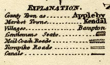
EXPLANATION. County Town as ... Appleby Market Towns ... Kendall Villages ... Bampton [italic] Gentlemens Seats ... [outline with fence palings] Mail Coach Roads ... [double line, feathered] Turnpike Roads ... [double line] Canals ... [bold line] |
|
|
|
||
|
orientation
compass rose up is N |
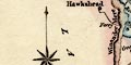
Printed lower left is a compass rose; star points for cardinal and half cardinal directions, North marked by a spear point. The map is printed with North at the top. |
|
|
|
||
|
scale line
scale |
Printed lower left is a:-
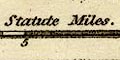
Scale of Statute Miles. chequered in miles to 5 then in 5 mile intervals. The 10 miles = 29.0 mm gives a scale 1 to 554946. The map scale is about:- 1 to 550000 9 miles to 1 inch |
|
|
|
||
|
coast line
coast form lines |
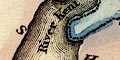
The small length of coast in the Kent Estuary is emphasized by form lines. |
|
|
|
||
|
rivers
bridges |
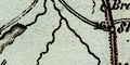
Rivers are drawn by a wiggly line tapering upstream. Some rivers are labelled, eg:- Emont R. River Kent Bridges are implied where a road crosses and interrupts a stream. None is labelled. |
|
|
|
||
| lakes |
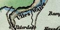
Lakes are drawn by an outline with form lines. Some lakes are labelled:- Hawes Water Ulles Water Winander Mere Other lakes might be recognized, eg:- Brothers Water Grasmere lake Loughrigg Tarn Rydal Water |
|
|
|
||
| forests |
Some forest areas are labelled, eg:-
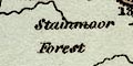
Stainmoor Forest Milbourn Forest |
|
|
|
||
| parks |
Parks are drawn by ban outline of fence palings, the
interior pecked. Some parks are labelled, eg:-
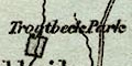
Levens Pa Trogtbeck Park |
|
|
|
||
| county |
The county boundary is a dotted or dashed line, irregularly engraved, not continued along a boundary feature like a river. The boundary is emphasized by a tint on the inner side of each county, ie including the adjacent counties: Westmorland blue, Lancashire pink, Cumberland green, Durham pink, Yorkshire yellow; there is no significance in the choice of colours. The blue tint for Westmorland is continued as a pale wash over the whole county area. Adjacent counties are labelled, eg:- CUMBERLAND |
|
|
|
||
| settlements |
Settlements are marked by a circle, differentiated by
style of labelling.
|
|
|
towns
distances from London |
circle; labelled in upright lowercase text, eg:-
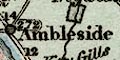
Ambleside / 272 Appleby / 263 The figures are the distance from London. According to the table of symbols the county town and other market towns are differentiated, but there is no difference. |
|
|
villages
hamlets |
circle; labelled in italic lowercase text, eg:-
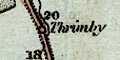
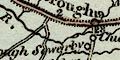
Thrimby Milthorp Shap Crosby Garret Marked by blocks is:- Little London [Stockdale, Longsleddale] Places are mostly those on roads; the last example is probably included for this reason, and is incorrectly shown on the road. |
|
|
|
||
|
roads
road distances post roads turnpike roads |
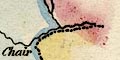
Roads are drawn by a double line. The post roads, 'Mail Coach Roads', have a fringe each side and are tinted red. The other roads are all declared as turnpike roads, but as they include the road and track up Longsleddale and over Gatescarth Pass I doubt that this is trustworthy. A number of roads have distances given at two mile intervals; perhaps these are the turnpike roads. Roads crossing the county boundary might be continued, with distances, to a destination town, or might be labelled with a destination. For example, the two post roads:- from the south, Lancashire; through Burton in Kendal, Kendall, Shap, Westmorland; over the Emont River , then Penrith, Cumberland, labelled:- The Gt. North Road from Carlisle from Eamont Bridge village, south of the river, through Appleby, Brough, Westmorland; cross the boundary at Maiden Castle, labelled:- to Bowes, Greta Br. & Catterick the London Road |
|
|
|
||
| canals |
The one canal is drawn by a bold line, labelled:-
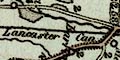
Lancaster Can |
|
Lakes Guides menu.