 Batty 1888

|

|
|
|
item:- Kendal Library (10_1) image:- © see bottom of page |
click to enlarge |
|
|
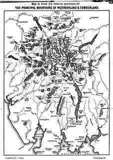
Map, uncoloured engraving? Principal Mountains of
Westmorland and Cumberland, scale about 4.5 miles to 1 inch,
by E C Batty, published by Sampson Low, Marston, Searle, and
Rivington, St Dunstan's House, Fetter Lane, Fleet Street,
London, 1888.
Opposite p.208 in Mountain Ascents in Westmoreland and Cumberland by John Barrow. |
||

|
Batty 1888 | |
| map feature:- | up is N & sea plain & coast form lines & rivers & lakes & relief & hill hachuring & spot heights & settlements (few, for orientation) & roman roads | |
| inscription:- |
printed top
Map to shew the relative positions of THE PRINCIPAL MOUNTAINS OF WESTMORLAND & CUMBERLAND. |
|
| inscription:- |
printed bottom, left and right
Compiled by E. C. Batty. / To face page 208. |
|
| wxh, map:- | 151x204mm | |
| scale:- | 1 to 300000 ? (estimate) | |
|
|
notes | |