 Batty 1888

|

|
|

|
back to object record | |
| MAP FEATURES | ||
|
The map includes from Caldbeck Fell to Humphrey Head N-S,
and from Ravenglass to Kendal W-E.
|
||
|
|
||
|
title
map maker |
Printed at the top:-
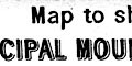
Map to shew the relative positions of THE PRINCIPAL MOUNTAINS OF WESTMORLAND & CUMBERLAND. and at the bottom:- Compiled by E. C. Batty. / To face page 208. Page 208 is the last page of the index, at the back of the book. |
|
|
|
||
|
orientation
up is N |
The map is printed with North at the top of the
sheet.
|
|
|
|
||
| scale |
No indicator of scale is given; the map declares it is
interested in relative positions. The map scale is estimated
as:-
scale: 1 to 300000 4.5 miles to 1 inch |
|
|
|
||
|
sea area
sea plain |
The sea area is plain. One part is labelled:-
MORECAMBE BAY |
|
|
|
||
|
coast line
coast form lines foreshore headlands |
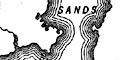
The coast line is emphasized by form lines. No foreshore is drawn but:- DUDDON SANDS are labelled. Some headlands are labelled, eg:- Humphrey Hd. Pt. Haverigg Pt. |
|
|
|
||
| rivers |
Rivers are drawn by wiggly line. Some rivers are
labelled, eg:-
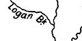
Logan Bk. R. Kent River Derwent Whicham Beck Worm Gill Russland Pool |
|
|
|
||
| lakes |
Lakes are drawn in outline with form lines. Most are labelled; the label sometimes obscured by the form lines:- BASSENTHWAITE WATER Blea Tn. [above Watendlath] Blea Water [Mardale] Bortree Tn. Tarn [Bowscale] Brothers Water Burnmoor Tarn BUTTERMERE CONISTON WATER CRUMMOCK WATER DERWENT WR. Devoke Water Easdale Tn. Elterwater ENNERDALE WR. ESTHWAITE WATER Grasmere lake Gt. Urswick Tarn Harrop Tarn HAWES WATER Keppel Cove T. Levers Water Low Wr. LOWES WATER Mockerkin tarn Red Tarn [Helvellyn] Rydal Water THIRLMERE ULLSWATER WAST WATER WINDERMERE Other lakes and tarns might be recognized, eg:- Floutern Tarn Goat Water Greendale Tarn Hayes Water Little Langdale Tarn Outdubs Tarn Scoat Tarn Seathwaite Tarn Sprinkling Tarn Styhead Tarn Watendlath Tarn Wythburn Head Tarn |
|
|
|
||
|
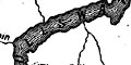
relief
hill hachuring spot heights |
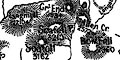
Relief, the principal mountains, is shown by hill hachuring, concentrated in the central Lake District. Most hills are labelled, with spot heights, eg:- Helvellyn / 311[6] Screes / 1945 Black Combe / 1969 Rydal Fell / 2122 FURNESS FELLS The hachuring obscures labels and heights. Some hill names are in a larger font, but this seems to reflect the availability of space rather than greater height. Not all hills can be shown, but there seems to be some unevenness. Kendal Fell (650 feet) and Underbarrow Scar are shown, but not Harter Fell, Kentmere Pike, etc. No detail assessment has been made but interest does reduce outside the central area, unless the author or map compiler has a particular interest in some hill. Some valleys are labelled, eg:- ESKDALE MARDALE Wrynose Bottom And passes, eg:- Hard Knot Pass Wrynose Ps Windy Gap |
|
|
|
||
| settlements |
Settlements are entirely incidental to the map's purpose,
and are marked by a few blocks, differentiated by style of
labelling.
|
|
| towns |
blocks; labelled in upright block caps, eg:-
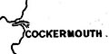
COCKERMOUTH KESWICK |
|
|
villages
hamlets |
blocks; labelled in italic lowercase text, eg:-
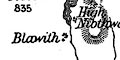
Blawith Staveley Corney |
|
|
|
||
| miscellaneous | ||
|
|
||
| beacons |
Notice:-
Beacon / 835 west of Coniston |
|
|
|
||
| mountain huts |
A dot north of Grange is labelled:-
Hospice of Hampsfell |
|
|
|
||
| monuments |
Alongside Hoad Hill is:-
Sir J. Barrow's Monmt. |
|
|
|
||
|
antiquities
roman sites roman roads |
Not along, but leading north from High Street is a dotted
line labelled:-
Roman Road |
|
|
|
||
|
antiquities
stone circles |
A circle outside Keswick is labelled:-
Druid Circle ie Castlerigg Stone Circle. |
|
Lakes Guides menu.