 Walker 1837

|

|
|
|
item:- JandMN (122) image:- © see bottom of page |
click to enlarge |
|
|
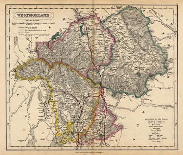
Map, Westmorland, scale about 3 miles to 1 inch, by J and
C Walker, about 1837, published by Longman, Rees, Orme,
Brown, Etc, Paternoster Row, London, 1837, edition about
1860s.
Plate 37 from an atlas. The map is ammended to include the 'Lancaster & Carlisle Raily.', 'Kendal & Windermere Raily.', and 'Nth. Western Raily.' ie Low Gill and Ingleton branch railway. |
||

|
Walker 1837 | |
| map feature:- | plain cartouche & up is N & scale line & lat and long scales & coast shaded & rivers & relief & hill hachuring & woods & forests & parks & county & electoral data & wards (hundreds) & settlements & roads & canals & railways | |
| inscription:- |
printed plain cartouche, upper left
WESTMORLAND / BY J. & C. WALKER |
|
| scale line:- | 10+1 miles = 93.1 mm | |
| scale:- | 1 to 190000 ? (1 to 1901481 from scale line) | |
| wxh, sheet:- | 44x35.5cm | |
| wxh, map:- | 381x323mm | |