 Bowles 1782

|

|
|
|
item:- private collection (6_75) image:- © see bottom of page |
click to enlarge |
|
|
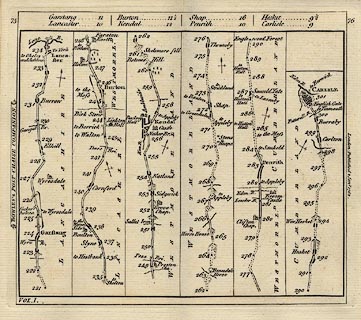
Road strip map, uncoloured engraving, London to Carlisle,
scale about 3 miles to 1 inch, derived from maps by Ogilby,
1675, published by Carington Bowles, London, 1782.
Published in the road book, Bowles's Post Chaise Companion, vol.1 pp.75-76. From Garstang through Lancaster, Lancashire; then Burton in Kendal, Kendal, and Shap, Westmorland; to Penrith and Carlisle, Cumberland. |
||

|
Bowles 1782 | |
| map feature:- | north point & up is destination & rivers & bridges & relief & hillocks & parks & county & settlements & roads & distances from London | |
| inscription:- |
printed upper cartouche
table of distances |
|
| inscription:- |
printed up lhs
BOWLES's POST-CHAISE COMPANION |
|
| inscription:- |
printed down rhs
London : Published 2 Jany. 1782 |
|
|
|
notes | |