 Bowles 1782

|

|
|

|
back to object record | |
| Road Book Contents | ||
|
The parts of Bowles's Post Chaise Companion that are
relevant to Westmorland, Cumberland, etc that are now
Cumbria, are:-
|
||
|
|
||
| road book |
Bowles's Post Chaise Companion
title page, volume 1:- BOWLES's Post-Chaise Companion; OR, TRAVELLERS DIRECTORY THROUGH ENGLAND and WALES: BEING AN ACTUAL SURVEY OF ALL THE Principal, Direct, and Cross-Roads, both Ancient and Modern; WITH THE DISTANCES expressed in single Miles according to Measurement: Exhibiting the several TOWNS, VILLAGES, POST-STAGES, &c. ON OR NEAR THE ROADS; Together with the Circuits of the Judges, and an exact Alphabetical LIST of all the FAIRS, as settled since the Alteration of the Style. IN TWO VOLUMES. VOL. I. LONDON: Printed for the Proprietor CARINGTON BOWLES, At his MAP and PRINT WAREHOUSE, No.69, St. Paul's Church Yard. The 'style' referred for the Fairs is the change of calendar from the Julian to the Gregorian style, September 1752. At this change Wednesday 2 September was followed by Thursday 14 September, and New Year's Day was changed from 25 March to 1 January. |
|
|
|
||
| general map |
General View of the Roads
England and Wales, scale roughly 80 miles to 1 inch, outline map with roads. |
|
|
|
||
| strip map |
London to Carlisle
From Garstang through Lancaster, Lancashire; then Burton in Kendal, Kendal, and Shap, Westmorland; to Penrith and Carlisle, Cumberland. |
|
|
|
||
| strip map |
Carlisle to Berwick
From Carlisle, through Stanwix, Cumberland; then Newcastleton, Jedburgh, and Kelso, Scotland; to Berwick on Tweed, Northumberland. |
|
|
|
||
| strip map |
Kendal to Cockermouth
Egremont to Carlisle From Kendal through Ambleside, Westmorland; then Keswick to Cockermouth, Cumberland; AND Egremont through Cockermouth, to Carlisle, Cumberland. |
|
|
|
||
| strip map |
Tinmouth to Carlisle
From Tinmouth, Northumberland; Newcastle. Durham; Hexham, Haltwesel, Northumberland; then Corby to Carlisle, Cumberland. |
|
|
|
||
| strip map |
London to Carlisle by Boroughbridge
From Boroughbridge through Leeming, Greta Bridge, and Bowes, Yorkshire; then Brough and Appleby, Westmorland; to Penrith, Cumberland. Being in volume 2, this is not included on the general map above. |
|
|
|
||
| itinerary |
Printed at the end of the strip map pp.199-200 is an
itinerary for:-
From Carlisle to Edinburgh the Road is to Longtown ... 9 / Langholm ... 11 / Mosspaul ... 10 1/2 / Hawick ... 13 / Selkirk ... 11 / Bankhouse ... 15 / Middleton ... 9 / Edinburgh ... 12 |
|
| MAP FEATURES | ||
|
These notes are for Cumbria interest and might ignore
features outwith that area.
|
||
|
|
||
|
title cartouche
plain cartouche itineraries map maker publisher |
Each sheet, printed as a pair of pages from one plate,
has a rectangular panel divided into 6 columns, the scrolls
of the forerunner maps by John Ogilby. Printed bottom left
is the volume number, eg:-
VOL. I. Printed upper left and right are page numbers, eg:- 75 / 76 Notice that these are not the normal way round for verso and recto pages of a book, the odd number is on the left. Printed on the left is the road book's title in a scroll cartouche:- BOWLES's POST-CHAISE COMPANION Printed on the right:- London: Published 2 Jany. 1782 Printed at the top of the sheet is the title of the route, if the sheet begins the strip map, and an itinerary for the strip map. Eg, page 157:- 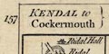
KENDAL to Cockermouth / Ambleside ... 13 / Keswick ... 16 1/2 / Cockermouth 14 |
|
|
|
||
|
orientation
north point up is the destination |
Each scroll has a north point; N-S line, E-W cross line, North marked by a spear point, East marked by a cross. Each segment of road is printed to be read up the page as you go forward, up is the destination. In rare instances where a road changes direction too much to fit in a narrow scroll a line is drawn across and there is a north point for each part. This does not occur in Cumbria, but an instance is found in vol.2 p.200 at Greta Bridge on the route through Borough Bridge to Penrith. |
|
|
|
||
| scale |
The maps have no scale line. Marks are made on the roads
at 1 mile intervals, labelled with the distance from the
start of the route. rom these it is possible to estimate a
scale about:-
3 miles to 1 inch. |
|
|
|
||
|
sea area
sea plain |
Very little sea is shown on the sheets for Cumbria. Vol.2
p.177 starts at Tinmouth where the sea that is shown is
plain.
|
|
|
|
||
|
coast line
coast form lines |
Vol.2 p.177, in the sheets for Cumbria, shows the coast
line at Tinmounth emphasised by form lines.
|
|
|
|
||
|
rivers
bridges |
Rivers, shown where they cross or are close to a road,
are drawn by a single or double wiggly line. Some rivers are
labelled, eg:-
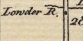
Lowder R. [Lowther] Eden R. [labelling the Eamont] Bridges are implied where a road crosses and interrupts a stream. A few bridges are labelled, eg:- 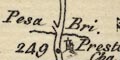
Pesa Bri. [Peasey Bridge] Eamont Br. (The latter is not on the sheet where the river is mislabelled.) |
|
|
|
||
| lakes |
Where a lake is close to a road it might be drawn in
outline, or part outline, with form lines by the shore. The
lake may be labelled. On the sheets for Cumbria there are,
labelled:-
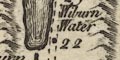
Wiburn Water [Thirlmere] Winander Mere And it is possible to recognise:- Rydal Water Derwent Water Bassenthwaite Lake |
|
|
|
||
|
relief
hill hachuring hillocks |
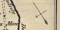
Ascents and descents in the road, and some adjacent relief, is indicated by hill hachuring or by little hillocks shaded to the east. Hillocks are all the asme way up, they are not inverted to show a descent. 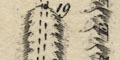
Hachuring enclosing a stretch of road suggests hilliness, with no clear indication of ups and downs except where a stream crossing provides a clue. Hillocks beside the road, on the segment north of Grasmere, suggest the mountains beside this route. Some hills might be labelled, eg:- Gresmere Hill Skelsmore fell |
|
|
|
||
|
woods
trees forests |
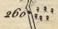
Woodland by the road might be indicated by little tree symbols. For example there is a small patch of woodland 3 miles north of Kendal, mile 260 on the London to Carlisle road, vol.1 pp.75-76. Forests might or might not have trees. At last on is labelled, vol.1 pp.75-76. mile 290:- Englewood Forest |
|
|
|
||
| parks |
A park might be shown by a ring of fence palings, the
interior with trees, and perhaps labelled, eg:-
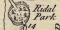
Ridal Park |
|
|
|
||
| county |
County boundaries are a dotted line; this might be a little offset from the natural boundary feature. The county through which the route goes is labelled along the length of the scroll, eg:- WESTMORELAND In Scotland the country name is given. |
|
|
|
||
|
settlements
street plan |
Settlements are marked by blocks or groups of blocks,
perhaps arranged on a miniature street plan, differentiated
by style of labelling.
|
|
|
cities
towns walls towns gates |
group of blocks on a street plan; labelled in upright
block caps:-
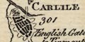
CARLISLE The town wall is shown with bastions, and town gates might be labelled, eg:- English Gate on vol. pp.75-76, where it is possible to see [imagine] the castle. The city appears on more than one scroll, different each time. |
|
| towns |
group of blocks, perhaps on a street plan; labelled in
upright lowercase text, eg:-
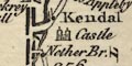
Kendal Penrith Notice that the de jure county town of Westmorland is labelled in italic block caps:- APPLEBY |
|
|
villages
hamlets |
block or blocks, or nothing at all; labelled in italic
lowercase text, eg:-
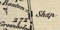
Shap Sidgwick Horse House A place is only likely to be included if it is on, or very close to the road. This style of labelling is used for other features. |
|
|
houses
castles churches |
Some places are marked by a drawing of a building, for
example:-
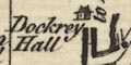
Dockray Hall [house] 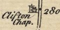
Clifton Chap. [building with tower] 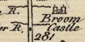
Broom Castle [building with two towers] These are more likely to be places off the road itself, which does not apply to Clifton Chapel unless the road has moved. |
|
|
|
||
|
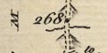
roads
road distances |
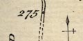
The roads are the reason for the maps. The road is drawn up the middle of the scroll by a double line, solid or dotted indicating fenced or unfenced roads. Miles are marked by a dot each mile, labelled with the distance from the start of the route. Turnings and cross roads are drawn, and might be labelled with a destination of the side road, eg:- 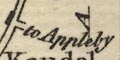
to Appleby to Saukold [Salkeld] Judging by the plot of Carlisle on vol.1 p.76, no particular care has been taken to label junctions with other strip map routes. |
|
|
|
||
| miscellaneous | ||
|
|
||
| stones |
A square is labelled:-
Birk Stone just before the Lancashire Westmorland border on the London to Carlisle road. Three square are labelled:- Stone Heaps 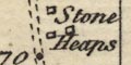
to the south of Shap |
|
|
|
||
|
antiquities
roman sites roman forts |
On the Yorkshire Westmorland boundary, vol.2 p.200, a
rectangle with marks at the corners seems to represent the
roman fort through which the road goes; with label:-
Rear Cross |
|
|
|
||
| inns |
Inns are sometimes noticed, eg:-
New Inn at mile 17 east of Brough, vol.2 p.200. |
|
|
|
||
| blacksmiths |
A smithy might be shown, presumably where none might be
expected.
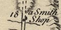
after Grasmere, before the ascent of Dunmail Raise. |
|
Lakes Guides menu.