 Bowles's Post Chaise Companion

|

|
|
|
map type:- Bowles 1782 |
|
|
|
Road book, strip maps with routes in Westmorland and
Cumberland etc, scale about 3 miles to 1 inch, derived from
maps by Ogilby, 1675, published by Carington Bowles, London,
1782.
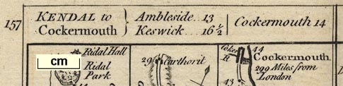
Published in two volumes 'BOWLES's Post-Chaise Companion; OR, TRAVELLERS DIRECTORY THROUGH ENGLAND and WALES: BEING AN ACTUAL SURVEY OF ALL THE DIRECT and CROSS ROADS, WITH THE MILE-STONES expressed as they stand at present: Exhibiting the several TOWNS, VILLAGES, POST-STAGES, &c. ON OR NEAR THE ROADS; Together with the Circuits of the Judges, and an exact Alphabetical LIST of all the FAIRS, as settled since the Alteration of the Style. / THE SECOND EDITION, CORRECTED, and greatly IMPROVED; with ADDITIONS. IN TWO VOLUMES. / VOL. II. / LONDON: Printed for the Proprietor CARINGTON BOWLES, At his MAP and PRINT WAREHOUSE, No.69, St. Paul's Church Yard. M DCC LXXXII.' ie 1782. The first edition was 1781? there are other undated editions. The strip maps are printed on one side only, folded, and pasted to a guard strip in the book; each map has two page numbers, printed at top left and right of the sheet. Plates concerning Westmorland are listed below. vol.1 pp.75-76 show from Garstang through Lancaster, Lancashire; then Burton in Kendal, Kendal, and Shap, Westmorland; to Penrith and Carlisle, Cumberland. vol.2 pp.157-158 show from Kendal through Ambleside, Westmorland; then Keswick to Cockermouth, Cumberland; AND Egremont through Cockermouth, to Carlisle, Cumberland. vol.2 pp.199-200 show from Boroughbridge through Leeming, Greta Bridge, and Bowes, Yorkshire; then Brough and Appleby, Westmorland; to Penrith, Cumberland. There is also a General View of the Roads, all of England and Wales, scale about 80 miles to 1 inch. |
||
|
(map example private collection (6_75))
|
||
| map feature:- | north point & up is destination & rivers & bridges & relief & hillocks & parks & county & settlements & roads & distances from London | |
| inscription:- |
printed upper cartouche
table of distances |
|
| inscription:- |
printed up lhs
BOWLES's POST-CHAISE COMPANION |
|
| inscription:- |
printed down rhs
London : Published 2 Jany. 1782 |
|
| references:- |
Bowles, Carington: 1782: Bowles's Post Chaise Companion &
Travellers Directory through England and Wales: (London) |
|
| sources:- |
Fordham 1924 David Webb Collection |
|
| items seen (illustrated items in bold):- | ||

|
private collection (6) -- road book -- Bowles's Post Chaise Companion | |
|
|
private collection (6_0) -- map -- General View of the Roads | |
|
|
private collection (6_75) -- strip map (pp.75-76) -- London to Carlisle -- Bowles's Post Chaise Companion | |
|
|
private collection (6_129) -- strip map (pp.129-130) -- Carlisle to Berwick -- Bowles's Post Chaise Companion | |
|
|
private collection (6_157) -- strip map (pp.157-158) -- Kendal to Cockermouth -- Egremont to Carlisle -- Bowles's Post Chaise Companion | |
|
|
private collection (6_177) -- strip map (pp.177-178) -- Tinmouth to Carlisle -- Bowles's Post Chaise Companion | |
|
|
private collection (6_199) -- strip map (pp.199-200) -- London to Carlisle by Boroughbridge -- Bowles's Post Chaise Companion | |