 Baker 1802

|

|
|
|
item:- private collection (3) image:- © see bottom of page |
click to enlarge |
|
|
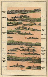
Perspective road maps with sections in Lancashire,
Westmorland and Cumberland, by J Baker, London 1802.
From Bolton to Carnforth, Lancashire; branches through Warton, Yealands, Milthorp, Beetham to Kendal, or passing Kellet and Borwick Hall, through Burton, Crooklands, Tenmoor to Kendal, Westmorland; a branch to Haweswater which should perhaps be Windermere, and the main route through Sonset Chapel, Shap, Clifton, and over Lowther Bridge to Penrith, Cumberland, then Plumpton, Upper carlton, to Carlisle, Cumberland. The map is pictorial - at the bottom right is a picture of an aqueduct with a sailing barge, the Lune Aqueduct? Kendal has its castle ruins ; Clifton has its castle; Penrith has its castle, and a tower on a hill to the east; Carlisle has a great river bridge, the cathedral, and the castle. Road distances are given, from ?London, for example carnforth 244, Kendal 260, Penrith 286, and Carlisle 304. Published in The Imperial Guide, with Picturesque Plans of the Great Post Roads, ... by H D Symonds, Paternoster-row, White, Fleet Street, Otridge, Strand, Richardson, Royal Exchange, Taylor, Holborn, Rivington, St Paul's Church Yard; Robson, and Carpenter, Bond Street, London, 1802. |
||

|
Baker 1802 | |
| inscription:- |
printed bottom centre
J. Baker delt. |
|
| wxh, map:- | 84x162mm | |
|
|
notes | |