 Baker 1802

|

|
|

|
back to object record | |
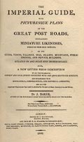
| THE IMPERIAL GUIDE | ||
|
Title page:-
|
||
|
||
|
THE IMPERIAL GUIDE WITH PICTURESQUE PLANS OF THE GREAT POST
ROADS, CONTAINING MINIATURE LIKENESSES, ENGRAVED FROM REAL
SKETCHES, OF THE CITIES, TOWNS, VILLAGES, SEAS, ISLANDS,
MOUNTAINS, PUBLIC EDIFICES, AND PRIVATE BUILDINGS, SITUATED
IN AND NEAR SUCH THOROUGHFARES. ALSO, A NEW LETTER PRESS
DESCRIPTION OF ALL THE CELEBRATED SCENERY AND LOCAL EVENTS
CONNECTED WITH THE ABOVE-MENTIONED SUBJECTS, AND
INTERSPERSED WITH BIOGRAPHICAL, CHRONOLOGICAL, AND
HISTORICAL ANECDOTES; AND ALL THE Important Illustrations
that could be attained by the most assiduous Investigation
and Survey. BY J. BAKER, AUTHOR OF THE PICTURESQUE GUIDE
THROUGH SOUTH WALES AND THE MARCHES. / Our Posey is as a
Gum, which oozes / From whence 'tis nourished. -
SHAKESPEARE. / LONDON: PRINTED BY C. WHITTINGHAM, Dean
Street, Fetter Lane, AND SOLD BY H. D. SYMONDS,
PATERNOSTER-ROW; WHITE, FLEET STREET; OTRIDGE, STRAND;
RICHARDSON, ROYAL EXCHANGE; TAYLOR, HOLBORN; RIVINGTON, ST.
PAUL'S CHURCH YARD; ROBSON, AND CARPENTER, BOND STREET.
1802.
|
||
|
Introduction
|
||
|
At the front of the volume, pp.iii and iv, is an:-
|
||
|
ADDRESS TO THE PUBLIC
|
||
|
That this work, either from its novelty or humble utility,
should have received Royal Patronage, and such distinguished
support, through that unhappy period when the arts most
suffered, and works of brighter genius failed, claims my
most unfeigned and ardent acknowledgements; for in neither
of the arts exercised upon it have I even professed superior
abilities. I was induced to my description of South Wales,
because, during a long residence in that part of the
principality, 'I found many of its internal beauties were as
little known, and as seldom visited, as the snow-top'd
acclivities of the Alps; and my chief purpose was, that my
observations might attract to the subject the attention of
authors more eminent and more competent to the task.' Since
that period, numerous indeed have been the Tourists who have
traversed those pleasing mazes of nature and antiquity, and
I flatter myself the signals I advanced were not wholly
useless. I only wish some of these Tourists had been less
tardy in their undertakings, as it would have saved me much
unproductive labour. My work was begun upon a very expensive
scale, in the days of profound peace, when the arts
flourished most; their's in the midst of an exhausting war,
and upon plans adapted to the temporary pressure of the
times. From these circumstances, some unforseen
disappointments, the unexpected advance on printing paper,
and other causes, I was disabled from proceeding farther in
my first work, than a completion of the two volumes of a
Description of South Wales and the Marches, now before the
public; and I had recourse to the less arduous and less
expensive task that is here offered to the public. In this,
my first intention was only to go through a description of
those roads which led immediately from London to the
Principality, till a happy change of circumstances might
enable me to carry on the above undertaking to its full
extent; or, failing in that hope, I flattered myself my
present production might be acceptable to the Subscribers to
the former, in as much as I give descriptions in it of those
plates of Landscape Views in North Wales, which I had
published and distributed with my Letter-Press descriptions
of the South. Thus rendering all the satisfaction in my
power to those numerous nobility, gentry, and others, who
first favoured, and have still continued to countenance my
endeavours, and I already find my purpose so far to have
succeeded, that much anguish is removed from my mind. And in
this work, I have been encouraged with so many liberal
offers from great and respectable families of engraved
plates of their seats, in other thoroughfares of the
kingdom. It is indispensable with the wish of my friends at
large, and my own personal interest, that I should prolong
it to these bounds. Should this narrative appear too
trifling for perusal, or frivolous for notice, let the
weakness be imputed to the ardent wish of proving to my
subscribers the nature of their kindness to me, and the high
value I entertain of their support; and I can solemnly
assure, that my assiduity and anxiety to please shall keep
pace with their offices of friendship to the extent of my
faculties, both of body and mind.
|
||
|
I cannot conclude without noticing some friendly
communications which have been made me, which will amend
some of my former descriptions, and which shall be carefully
noticed in the additional Letter-Press to be printed for
such gratuitous plates as may not immediately appear in the
great roads, in that which will be formed for the Cross
Roads, or in some other part of the Appendix which I have
promised to the work. Also, those errors which I perceive to
have escaped my pen in spelling the provincial and other
names, shall as far as possible be rectified in an errata,
and I humbly hope others will not fail their countenance of
such assistance to those subjects, as may render this
production more and more complete.
|
||
| MAP FEATURES | ||
|
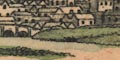
The Imperial Guide has descriptive text supported by a
series of road strip maps drawn as prospects, in
perspective. On each plate there is a series of tiny
prospects of the towns, villages, and great houses on the
route, connected by a fine dotted line of of the road. There
are captions at the side giving place names and distances
from London.
|
||
|
|
||
| map maker |
Printed at the bottom:-
J. Baker delt. |
|
|
|
||
|
orientation
up is destination up is N |
The drawings are arranged so that up is forward, you go
up the page the way you travel. Plate opp.25 is printed with
North at the top of the sheet, roughly.
|
|
|
|
||
|
scale
not to scale |
The maps have no scale. The road on plate opp.25 starts
at 239 miles from London and continues to 304, in about
128mm; very crudely the scale is
1 to 800000 13 miles to 1 inch This is a very crude estimate; the maps are not to scale. |
|
|
|
||
|
rivers
bridges |
Some settlements have a bridge in their drawing, and
perhaps show the river. For example at Carlisle:-
and see Lowther Bridge:- 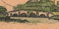
|
|
|
|
||
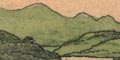
| lakes |
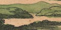
Two lakes are shown nestled in hills and mountains:- Haweswater / 268 and, described in his text but not labelled:- Ullswater |
|
|
|
||
| relief |
Hills are only shown as incidental elements in the drawings. For example see the hills around Ullswater, and more recognisably:- Beacon Hill [Penrith] Castle Hill [Kendal] |
|
|
|
||
| woods |
Wooded areas are included as incidental elements in the drawings. |
|
|
|
||
|
settlements
distances from London |
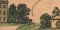
Settlements, or houses, are drawn as miniature prospects.
There is no firm relationship between size of drawing and
size of place; lower on the page tend to be bigger because
closer. However it is possible to guess at the implied size
of place by what is drawn, distinguishing town from village.
Churches are drawn with towers or a spire.
Places are labelled in the map margins, with distances from London in figures, eg a city:- 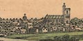
Carlisle / 304 a town:- 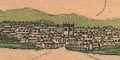
Kendal / 260 and an unidentified village:- 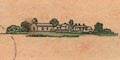
|
|
|
|
||
| roads |
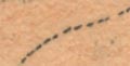
Roads are drawn by a fine dotted line connecting sketch to sketch, place to place. This is not a plot of the road. |
|
|
|
||
| canals |
The Lune Aqueduct carrying the Lancaster Canal over the
River Lune is shown to the right of the road:-
Aquaduct / 239 with a sailiung barge crossing on the canal. |
|
| CUMBRIA ROADS | ||
|
Plate opposite page 25:-
|
||
| DESCRIPTIVE TEXT | ||
|
The text for the road through Westmorland and Cumberland,
now Cumbria, is on pp.25-27, part of the section headed, on
page 22
|
||
|
MANCHESTER to CARLISLE, &c.
|
||
|
...
|
||
Lakes Guides menu.