 Kitchin 1784

|

|
|
|
item:- private collection (48) image:- © see bottom of page |
click to enlarge |
|
|
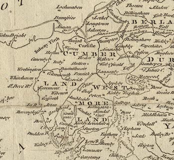
Map, uncoloured engraving, Great Britain, England and
Wales, scale about 27 miles to 1 inch, surveyed by Thomas
Kitchin, publisher in the New and Complete British
Traveller, by Walpoole, 1784.
The counties and a selection of settlements are shown. |
||

|
Kitchin 1784 | |
| map feature:- | plain cartouche & compass rose (fairly plain, north indicated by fleur de lys, east by a cross) & scale line (statute miles) & lat and long scales & lat and long grid & table of symbols (different sizes of settlement, sand and rocks) | |
| inscription:- |
printed title cartouche
A New and / Accurate Map of / that District of / GREAT BRITAIN, / called England & Wales. &c. / from the / latest & most Correct / SURVEYS / by T. KITCHEN, / Geographer & hydrographer to His / MAJESTY. landscape with ships, travellers, and a lion! |
|
| inscription:- |
printed top
London : Published by Alexr. Hogg at the Kings Arms, No.16 Paternoster Row |
|
| inscription:- |
printed bottom
N.B. The New & Correct MAPS of SCOTLAND, IRELAND, &c. will be given COMPLETE in the Course of the Publication. |
|
| wxh, plate:- | 34.5x39cm | |
| wxh, map:- | 337x369mm | |
| scale:- | 1 to 1700000 ? (estimated) | |
|
|
notes | |