 Kitchin 1784

|

|
|

|
back to object record | |
| MAP FEATURES | ||
|
The notes are biased towards Cumbria interest, features
outwith this area might be ignored.
|
||
|
|
||
|
title
map maker publisher |
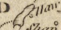
Printed in a title cartouche with a landscape with ships,
travellers, and a lion!:-
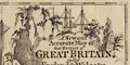
A New and Accurate Map of that District of GREAT BRITAIN, called England & Wales. &c. from the latest & most Correct SURVEYS by T. KITCHEN, Geographer & hydrographer to His MAJESTY. Printed at the top:- London: Published by Alexr. Hogg at the Kings Arms, No.16 Paternoster Row Printed at the bottom:- N.B. The New & Correct MAPS of SCOTLAND, IRELAND, &c. will be given COMPLETE in the Course of the Publication. |
|
|
|
||
|
orientation
up is N |
The map is printed with North at the top of the
sheet.
|
|
|
|
||
| scale |
The map scale has been estimated roughly:-
1 to 1700000 27 miles to 1 inch |
|
|
|
||
|
sea area
sea plain |
The sea area is plain. Some sea areas are labelled,
eg:-
Solway Firth |
|
|
|
||
|
coast line
foreshore headlands |
The coast line is not emphasised. Some areas of foreshore sands are outlined by a dotted line, for example the south Cumberland and the Lancashire coasts. A headland might be noticed, eg:- St. Bees Hd. |
|
|
|
||
| rivers |
A few rivers are drawn by a wiggly line tapering
upstream; and some of these might be labelled, eg:-
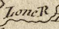
Lone R Or the river estuary might be labelled, eg:- 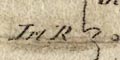
Irt R Duddon R In Cumbria it is possible to recognise, as well as the Lune, the Crake, Leven, Eamont, Eden, Derwent, Irthing, Esk ... |
|
|
|
||
| lakes |
A few lakes are drawn by an outline, possibly with some shaded shore. The following lakes can be recognised:- Coniston Water Ullswater Windermere |
|
|
|
||
| relief |
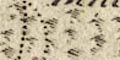
No mountains or hills are indicated in Cumbria. But some small hillock symbols indicate relief in Yorkshire, Sedbergh and Dent southward. |
|
|
|
||
|
woods
trees |
No woodland is indicated in Cumbria. But little tree symbols with dotting for undergrowth are labelled:- Lune For. north of Brough west of Bowes, in Yorkshire. |
|
|
|
||
| country |
The country boundary is a dot dash line. |
|
|
|
||
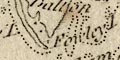
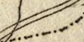
| county |
County boundaries are a dotted line. The county areas are labelled, eg:- WESTMORELAND CUMBERLAND |
|
|
|
||
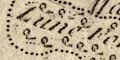
| settlements |
A selection of settlements is given. Settlements are
marked by a circle with vestigial added elements,
differentiated by style of labelling.
|
|
| cities |
circle, ?buildings; labelled in upright lowercase text,
eg:-
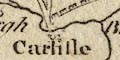
Carlisle |
|
| towns |
circle and vestigial tower; labelled in italic lowercase
text, eg:-
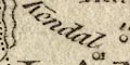
Kendal Ambleside |
|
|
villages
hamlets |
circle; labelled in italic lowercase text, eg:-
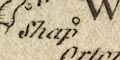
Shap Kirk Oswald Wibourn [Wythburn] |
|
| castles |
circle with a ?flag; labelled in italic lowercase text,
eg:-
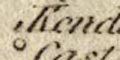
Kendal Cast Askerton Cast |
|
|
|
||
| roads |
Roads are not shown in most of Cumbria, but two roads are
drawn by a double line, not well engraved, north of
Carlisle:-
from Carlisle, across Sark Bridge, Cumberland; to Annan, Dumfries etc, Scotland. from carlisle, through Longtown, Cumberland; along the border in Scotland and England towards Berwick. |
|
|
|
||
| miscellaneous | ||
|
|
||
|
antiquities
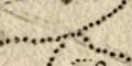
roman sites roman wall |
Running eastward from Carlisle is a crenellated line
labelled:-
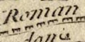
Roman Wall |
|
Lakes Guides menu.