 Hall 1833

|

|
|
|
item:- JandMN (47_1) image:- © see bottom of page |
click to enlarge |
|
|
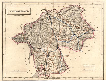
Map, hand coloured engraving, Westmoreland ie
Westmorland, scale about 5 miles to 1 inch, by Sidney Hall,
published by Chapman and Hall, 186 Strand, London, about
1860s.
The imprint is missing from the bottom, but the map was bought with 2 other sheets from the same atlas, all marked with county name on the back by an owner in the same way, which convinces me they belong together. The map, first published 1833, is probably from the Travelling County Atlas or the New County Atlas by Sidney Hall, as engraved uptodate for the 1840s but with manuscript additions, coloured railways to the 1860s. |
||

|
Hall 1833 | |
| map feature:- | plain cartouche & north point & scale line & lat and long scales & coast shaded & rivers & lakes & relief & hill hachuring & parks & county & wards (hundreds) & table of wards (hundreds) & settlements & roads & railways & canals | |
| inscription:- |
printed in and below title cartouche, upper left
WESTMORELAND. / ENGRAVED BY S. HALL. |
|
| inscription:- |
printed with scale line
English Miles. |
|
| scale line:- | 10 miles = 48.9 mm | |
| scale:- | 1 to 330000 ? (1 to 329109 from scale line) | |
| wxh, sheet:- | 28x21cm | |
| wxh, folded (in atlas):- | 14x21cm | |
| wxh, map:- | 249x191mm | |
|
|
notes | |