 Dawson 1830s

|

|
|
|
item:- JandMN (214) image:- © see bottom of page |
click to enlarge |
|
|
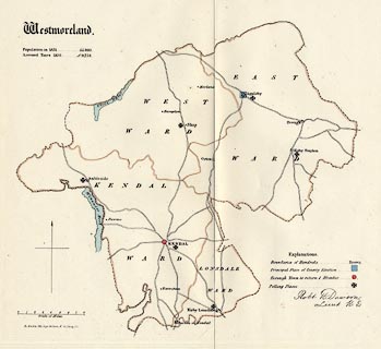
Map, hand coloured lithograph, Westmoreland ie
Westmorland, scale about 4 miles to 1 inch, showing the
proposed parliamentary divisions, made for the Reform Bill
1832, by Lieut Robert K Dawson RE, 1831, perhaps copied
1937?
Lithographed by R Martin, London; shows proposed division of the county, principal places of county election, boroughs returning 2 members and 1 member. This may be a copy from the Report of the Municipal Corporation Boundaries Commission, 1937. |
||

|
Dawson 1830s | |
| map feature:- | county & wards (hundreds) & roads & settlements & scale line & north point & table of symbols & electoral data | |
| inscription:- |
printed upper left
Westmoreland. engish black letter |
|
| inscription:- |
printed ms lower right
Robt. K. Dawson, / Lieut. R.E. |
|
| inscription:- |
printed lower left, below scale line
R. Martin, lithog. 124, High Holborn & 51, Carey St. |
|
| scale line:- | 8 miles = 49.6 mm | |
| scale:- | 1 to 260000 ? (1 to 259572 from scale line) | |
| wxh, sheet:- | 36x34cm | |
|
|
notes | |