 Cooke 1802

|

|
|
|
item:- Hampshire Museums : FA2000.62.4 image:- © see bottom of page |
click to enlarge |
|
|
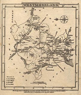
Map, Westmoreland ie Westmorland, scale about 12 miles to
1 inch, by George Cooke, 1802, published by Sherwood, Jones
and Co, Paternoster Road, London, 1824.
Included in Gray's New Book of Roads, 1824. |
||

|
Cooke 1802 | |
| map feature:- | plain cartouche & compass rose & up is E & scale line & lat and long scales (beware the longitude minute numbering is wrong) & coast form lines & rivers & lakes & parks & county & wards & table of wards & settlements & roads & distances from London | |
| inscription:- |
printed top right
4 |
|
| inscription:- |
printed top
WESTMORELAND |
|
| inscription:- |
printed with scale line
Scale of Statute Miles |
|
| scale line:- | 10 miles = 21.5 mm | |
| wxh, sheet:- | 12x14.5cm | |
| wxh, map:- | 108x123mm | |
| scale:- | 1 to 750000 ? (1 to 748532 from scale line) | |
|
|
notes | |