 Cooke 1802

|

|
|

|
back to object record | |
| MAP FEATURES | ||
|
These notes are mostly made from the Westmorland map, with
extra material from the adjacent maps. Notes from the map of
The Lakes in the series are not included here.
|
||
|
The Westmorland map is plate 4. Other maps in the road book
relevant to Cumbria are: plate 1 South of Scotland; plate 2
Cumberland; plate 3 Northumberland; plate 6 Lancashire;
plate 9 Durham; plate 11 North Riding of Yorkshire; plate 12
West Riding of Yorkshire.
|
||
|
|
||
|
title cartouche
plain cartouche |
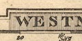
Printed in a shaded rectangular cartouche upper centre is:- WESTMORELAND |
|
|
|
||
|
orientation
compass rose up is E |
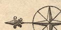
Printed upper right is a compass rose; circle, star points for cardinal directions, lines for half cardinal directions, North marked by a fleur de lys. The map is printed with East at the top of the sheet. Other maps in the series are printed other ways: South of Scotland, up is E; Cumberland, up is N; Northumberland, up is N; Lancashire, up is N; Durham, up is W; North Riding of Yorkshire, up is W; West Riding of Yorkshire, up is W. |
|
|
|
||
|
scale line
scale |
Printed lower middle is a:-
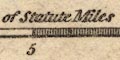
Scale of Statute Miles chequered and labelled in 5 mile intervals. the 10 miles = 21.5 mm gives a map scale 1 to 748532. The map scale is about:- 1 to 750000 12 miles to 1 inch Other maps in the series are to different scales, roughly: Cumberland, 15.5 miles to 1 inch; Northumberland, 17.5 miles to 1 inch; Lancashire, 18 miles to 1 inch; Durham, 11.5 miles to 1 inch; North Riding of Yorkshire, 21 miles to 1 inch; West Riding of Yorkshire, 21 miles to 1 inch. |
|
|
|
||
|
lat and long
lat and long scales |
Printed in the map borders are scales of latitude and longitude for a rectangular projection; chequered and labelled at 5 minute intervals. NB: the minutes of longitude at the left and right are labelled incorrectly upwards, as latitude would be, instead of downwards. The map seems to include from 2d 29m to 3d 12m W, from 53d 54m to 54d 30m N; the whole of Westmorland. Interpreting from the scales the longitude, Kendal = 2d 53.5m W as it should be about 2d 45m the discrepancy suggests that the scales are unreliable, rather than a prime meridian 10m W of Greenwich? |
|
|
|
||
| sea plain |
There is no sea on the Westmorland map. The sea off
Cumberland is plain.
|
|
|
|
||
|
coast line
coast form lines |
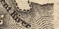
The small bit of coast line in the Kent Estuary is drawn with form lines. The coast on the Cumberland map is the same. |
|
|
|
||
| rivers |
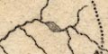
Rivers are drawn by a wiggly line tapering upstream. Rivers have tributaries filling available space. Some rivers are labelled, eg:- Kent River Tees Riv. Eden R. |
|
|
|
||
| lakes |
Lakes are drawn in outline with form lines. Some lakes
are labelled:-
Winander Mere Horns Water [Haweswater] Ulles Water Others might be recognised:- Brothers Water Cow Green Reservoir (now) Elter Water (?) Grasmere Kentmere Tarn Loughrigg Tarn (?) Rydal Water Skeggles Water [decoy pond, Lowther] The Cumberland map labels:- Bassenthwaite Water Burnmoor tarn Crummock Water Derwent Water Ennerdale Water Thirle Meer Ulles Water Wast Water and also shows:- Buttermere Lowes Water The Lancashire map labels:- Coniston Water Winander Meer and also shows:- Esthwaite Water |
|
|
|
||
| relief |
No relief is indicated by the map.
|
|
|
|
||
| parks |
Parks are drawn by a simplified outline with fence
palings, the interior pecked. Some parks are labelled,
eg:-
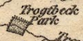
Trogtbeck Park Levens Pa. Killington P. |
|
|
|
||
| county |
The county boundary is a dashed line which might or might not be continued where it coincides with another feature. For instance it is shown through Ullswater and shown down the river Winster, but not shown round Windermere or along the River Tees. Adjacent counties are divided, and labelled, eg:- LANCASHIRE YORK SHIRE Some features are shown outwith the county area for the continuity of roads, for example in the Sedbergh and Ingleton areas, and at Penrith. |
|
|
|
||
|
wards
table of wards |
Ward, comparable to hundred, boundaries are dotted lines. The ward areas are labelled by number keying to a table printed lower left:- WARDS 1 east ward 2 West Ward 3 Kendall 4 Lonsdale Printed at the bottom of this, uncoloured, map is:- The County Town is denoted by red and the respective Hundreds of the County by different Colours which distinctions are peculiar to the superior Edition. One coloured map seen, of Cumberland, has colour on the county boundary but not on the hundred boundaries, and several towns are picked out by red. Perhaps this was done by a later colourist who has not read the instructions. |
|
|
|
||
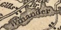
|
settlements
electoral data distances from London |
Settlements are marked by blocks, differentiated by style
of labelling.
|
|
| cities |
On the companion map of Cumberland a city is marked by
blocks; labelled in upright block caps.
|
|
| towns |
blocks; labelled in upright lowercase text, eg:-
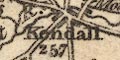
Kendall / 257 Ambleside / 281 except APPLEBY / 267 [2 stars] in italic block caps as the de jure county town, a borough returning two members to Parliament, shown by the stars. the figures are distances from London. The map might be found coloured, as noted at the bottom:- The County Town is denoted by red ... which distinctions are peculiar to the superior Edition. |
|
|
villages
hamlets |
blocks; labelled in italic lowercase text, eg:-
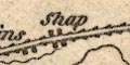
Shap Staveley Crosslands |
|
|
|
||
|
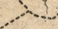
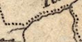
roads
post roads |
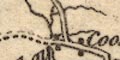
A network of roads is drawn by double lines.Two routes are emphasised by shading along the lines, perhaps post roads. 
These two routes are:- from the south, Lancashire; through Burton in Kendal, Kendal, Shap, Westmorland; then Penrith and north, Cumberland. from the east, Yorkshire; through Brough, Appleby, joining the N-S route at the River Lowther, Westmorland. The destinations of some roads is given at the county boundary, eg:- to Bowes, Greta Br. & Catterick - the London Road to Lancaster London R. to London by Settle to Keswick &c - the Whitehaven Road from Carlisle - the Gt. North Road and so on. |
|
|
|
||
| canals |
It is possible to imagine a line ending at Kendal as the
Lancaster Canal.
|
|
Lakes Guides menu.