 Bartholomew 1920s

|

|
|
|
item:- JandMN (30) image:- © see bottom of page |
click to enlarge |
|
|
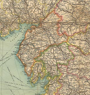
Map, colour printed, Tourist's Map of England and Wales,
northern section including Westmorland, Cumberland etc,
scale about 10.5 miles to 1 inch, published by John
Bartholomew and Son, The Geographical Institute, Duncan
Street, Edinburgh, Lothian, 1920s?
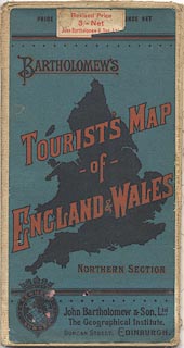
The back cover has an index map and advertisement for Bartholomew's quarter inch road maps. |
||

|
Bartholomew 1920s | |
| map feature:- | mounted & folded & card cover & up is N & scale line & lat and long scales & lat and long grid & sea tinted & coast line & coast tinted & rivers & lakes & spot heights (a few) & county & settlements & roads & railways & shipping routes | |
| inscription:- |
trade mark: printed over title, upper right
WORLD SURVEY / BARTHOLOMEW'S / MAP SERIES lamp and globe |
|
| inscription:- |
printed upper right
TOURIST'S MAP / OF / ENGLAND & WALES / Reduced by Perission from the / ORDNANCE SURVEY / / BY JOHN BARTHOLOMEW, F.R.G.S. |
|
| inscription:- |
printed above scale line, upper right
Scale 1 : 633,600 10 miles to an Inch |
|
| inscription:- |
printed bottom, left, centre and right
THE EDINBURGH GEOGRAPHICAL INSTITUTE / BARTHOLOMEW'S TOURIST'S MAP OF ENGLAND & WALES - NORTHERN SECTION / JOHN BARTHOLOMEW & Co. |
|
| inscription:- |
printed cover
PRICE [ ] NCE NET / BARTHOLOMEW'S / TOURIST'S MAP / OF / ENGLAND & WALES / NORTHERN SECTION / John Bartholomew & Son, Ltd., / The Geographical Institute, / DUNCAN STREET, EDINBURGH. red and black on blue; silhouette image i=of England and Wales |
|
| inscription:- |
printed cover
REDUCED SURVEY globe and crown |
|
| scale line:- | 40 miles = 98.3 mm | |
| scale:- | 1 to 650000 ? (1 to 654870 from scale line) | |
| wxh, sheet:- | 84.5x57.5cm | |
| wxh, folded:- | 10.5x20cm | |
| wxh, map:- | 821x541mm | |
|
||
|
||