 Lloyd 1573

|

|
|
|
item:- Hampshire Museums : FA1998.69 images:- © see bottom of page |
click to enlarge |
|
|
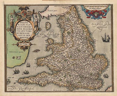
Map, hand coloured copper plate engraving, Angliae Regni,
Kingdom of England, with Wales, scale about 24 miles to 1
inch, authored by Humphrey Lloyd, Denbigh, Clwyd, drawn and
engraved by Abraham Ortelius, Netherlands, 1573.
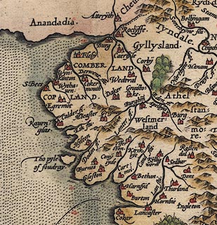
County boundaries are not shown, but Cumbria can be seen clearly in its setting of northern England. The colouring is believed to be original; the text on the reverse is in Latin; the error in the numbering of the scale line puts this map as one of the first version; the reference book about Ortelius's maps gives the scale as 1 to 1150000; from the scale line the scale can be estimated as about 1 to 1360000, from measuring positions of major towns on the map the scale is better estimated as 1 to 1520000, ranging from say 1 to 1.46 to 1.59 million. |
||

|
Lloyd 1573 | |
| map feature:- | picture frame border & strapwork cartouche & coat of arms (royal) & labelled borders & scale line (chequered, slanted lines indicating variation in scale at different latitudes) & sea stippled & galleons & sea monsters & coast shaded & rivers & relief & hillocks & forests & country & settlements | |
| inscription:- |
printed title cartouche
ANGLIAE / REGNI FLO : / RENTISSIMI / NOVA DESCRIP : / TIO, AUCTORE / HUMFREDO / LHUYD DEN : / BYGIENSE / 1573 / Cum Privilego |
|
| inscription:- |
watermark:
baroque cartouche and motif |
|
| inscription:- |
printed borders
SEPTENTRIO. / ORIENS. / MERIDIES. / OCCIDENS. |
|
| inscription:- |
printed scale of miles
10 20 30 40 60 60 70 80 / Scala miliarum Anglicorum note the error in the numbers |
|
| scale line:- | 80 miles = 97.0 mm (perhaps) | |
| scale:- | 1 to 1500000 ? (roughly, from position of a few towns) | |
| scale:- | 1 to 1300000 ? (1 to 1327294 from scale line wrongly assuming a statute mile) | |
| wxh:- | plate | |
| wxh, sheet folded:- | 27.5x43cm | |
|
||
|
|
notes | |