 Lloyd 1573

|

|
|

|
back to object record | |
| MAP FEATURES | ||
|
|
||
| picture frame border |
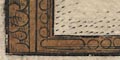
The map has a border engraved to look like wooden picture framing. |
|
|
|
||
|
title cartouche
strapwork cartouche map maker coat of arms |
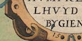
Printed upper left is a strapwork cartouche supported by naked goddesses, decorated with a few fruits and birds. The title is:- ANGLIAE REGNI FLORENTISSIMI NOVA DESCRIPTIO, AUCTORE HUMFREDO LHUYD DENBYGIENSIS 1573 Cum Privilegio The map is by Humphrey Lloyd, Denbigh, Clwyd. It was published in an atlas by Abraham Ortelius, Netherlands, 1573. The map covers England and Wales, with the Isle of Man. Parts of Scotland and Ireland are shown in outline with a few places. Above the title is the royal coat of arms of the period; England quartered with France:- quarterly 1 and 4 azure three fleur de lys or, 2 and 3 gules three lions passant guardant or. |
|
|
|
||
|
orientation
labelled borders up is N |
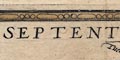
The map is printed with north at the top. The four map borders are labelled:- Septentrio. short for Septentriones, Oriens. Meridies. Occidens. North, East, South, West. |
|
|
|
||
|
scale line
scale |
Printed upper right is:-
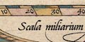
Scala miliarum Anglicorum chequered at 5 mile intervals, labelled at 10 miles intervals. The length of the scale line is uncertain, the ends are slanted! for the variation in scale at different latitudes. Taking 80 miles = 97 mm gives a scale 1 to 1327294. Thus map scale is about:- 1 to 1300000 But a better estimate comes from considering the position of a few major towns, giving a map scale about:- 1 to 1500000 24 miles to 1 inch |
|
|
|
||
|
sea area
sea pecked swash lettering |
The sea area is pecked. The sea area here is labelled in
beautiful swash lettering:-
MARE HIBERNICUM |
|
|
|
||
|
coast line
coast shaded |
The coast line is shaded for emphasis, tinted blue. The coast line is fairly crude, as is most of this early map at this large scale. In particular Furness needs stretching south westerly. A large island off the Duddon Estuary is labelled:- Tho pyle of foudray This is not shaped like Walney, which is not shown. |
|
|
|
||
| rivers |
Rivers are drawn by a double line tapering upstream. The
lowest part might be shaded, for example see the Esk, or
perhaps have minimal form lines, for example see the Eden.
Some rivers are labelled, eg:-
Eden fl. Dodon fl. [Duddon] Cand flu. [Kent] |
|
|
|
||
| lakes |
No lakes are shown at all.
|
|
|
|
||
|
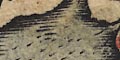
relief
hillocks |
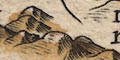
Relief is indicated by hillocks shaded to the east, tinted brown. No overall impression of the hilly middle of the Lake District is given. Hills are not labelled. |
|
|
|
||
|
forests
trees |
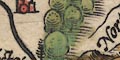
A group of large tree symbols, as big as the hillocks, marks a forest east of Corby. |
|
|
|
||
| county |
There are no county boundaries. There are labels:-
Westermland COMBERLAND but there are also other equally important looking area labels:- COPLAND Gyllysland |
|
|
|
||
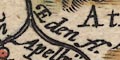
| settlements |
Settlements are positioned by a dot and circle. Each has
a tower or towers, but these bear little or no relation to
the importance of the place. All are labelled in the same
style and are tinted red.
|
|
|
cities
towns villages |
dot and circle, towers; labelled in elegant italic
lowercase text, eg:-
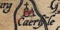
Caerlyle [Carlisle] 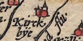
Kirckbye [Kendal] Apelbya [Appleby] Grosmere [Grasmere] Daker [Dacre] |
|
Lakes Guides menu.