 Cary 1798 map 2

|

|
|
|
item:- private collection (20_2) image:- © see bottom of page |
click to enlarge |
|
|
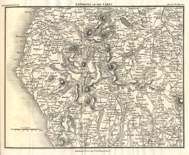
Map, uncoloured engraving, Environs of the Lakes, scale
about 5 miles to 1 inch, by John Cary, published by G and J
Cary, 86 St James's Street, London, 11th edn 1828.
Included in Cary's New Itinerary, 11th edn, 1828. |
||

|
Cary 1798 map 2 | |
| map feature:- | up is N & scale line & sea plain & coast shaded & rivers & lakes & relief & hill hachuring & parks & county & settlements & roads & road distances & distances from London & canals | |
| inscription:- |
printed top, left, centre and right
ELEVENTH EDITION. / ENVIRONS OF THE LAKES . / For Cary's New Itinerary |
|
| inscription:- |
printed bottom
Published by G. & J. Cary No.86 St. James's Street |
|
| scale line:- | 7 miles = 33.9 mm | |
| wxh, sheet:- | 23x18.5cmcm | |
| wxh, map:- | 210x167mm | |
| scale:- | 1 to 330000 ? (1 to 332313 from scale line assuming a statute mile) | |
|
|
notes | |