 Cary 1798 map 2

|

|
|

|
back to object record | |
| MAP FEATURES | ||
|
|
||
|
title
map maker publisher |
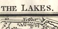
Printed at the top, left, centre and right:- ELEVENTH EDITION. / ENVIRONS OF THE LAKES . / For Cary's New Itinerary Printed at the bottom:- Published by G. & J. Cary No.86 St. James's Street G and J are George and John Cary. |
|
|
|
||
|
orientation
up is N |
The map is printed with North at the top of the
sheet.
|
|
|
|
||
|
scale line
scale |
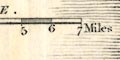
Printed lower left is a:- SCALE chequered and labelled in miles. The 7 miles = 33.9 mm gives a scale 1 to 332313 assuming a statute mile. The map scale is about:- 1 to 330000 5 miles to 1 inch |
|
|
|
||
|
sea area
sea plain |
The sea area shown, the Irish Sea, is plain and
unlabelled.
|
|
|
|
||
|
coast line
coast shaded |
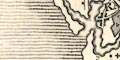
The coast line is emphasised by shading in two stages; bold immediately offshore continued light further into the offing. |
|
|
|
||
|
rivers
bridges |
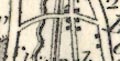
Rivers are drawn by wiggly line tapering at the head. A broad river might be engraved with a light line or two parallel the river to suggest its wider size, and an estuary might have form lines. Some rivers are labelled, eg:- Derwent R Emont R. R. Lune or Loyne Bridges are implied where a road crosses and interrupts a stream. A bridge might be labelled, eg:- 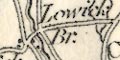
Lowick Br. Lowther Br. There seems to be a bridge across the width of Thirlmere:- 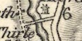
Before the lake was deepened to become Thirlmere Reservoir there was a narrow stretch crossed by a succession of three footbridges. |
|
|
|
||
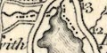
|
lakes
islands |
Lakes are drawn in outline with ?form lines. Some lakes are labelled:- BASSENTHWAITE WATER Broader Water [Brothers Water] Burnmoor Tarn Buttermere Water CONISTON WATER CRUMMOCK WATER DERWENT WATER Devock L Easthwaite Water Eller Water [Elter Water] ENNERDALE WATER HALLS WATER [Haweswater] The Tarn [Kentmere Tarn] LOWES WATER Over water Skeggles Water Thirle Mere Lake Thurle Mere [actually Grasmere+Rydal Water] ULLES WATER WAST WATER WINANDER MERE Other smaller lakes and tarns might be recognised, amongst which:- Hayeswater Little Langdale Tarn (?) Whinfell Tarn (?) Islands are mostly not noticed, but there is a small island in Ennerdale Water, and Belle Isle in Windermere is clearly represented. |
|
|
|
||
|
relief
hill hachuring spot heights |
Relief is indicated by hill hachuring. Some individual
peaks are drawn emphatically, but the overall impression is
not very helpful. A few hills are labelled, some with a spot
height, eg:-
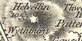
Helvellin / 1055 Skiddaw / 3022 ft. Hay Cock A valley night be labelled, eg:- Borrowdale |
|
|
|
||
| forests |
Woodland is not indicated, but some forest areas are
labelled, eg:-
COPELAND FOREST Whinfell Forest |
|
|
|
||
| parks |
Parks are drawn in outline with fence palings, the
interior pecked, perhaps with small tree symbols. A park
might be labelled, eg:-
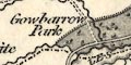
Gowbarrow Park Graystock Park |
|
|
|
||
| county |
County boundaries are a dot dash line, but this is not continued all along a boundary feature like a river. Enough overlap of dotted line and feature is given to suggest the function of the feature. Two county areas are labelled:- WESTMORELAND CUMBERLAND And the county boundary separating Lancashire from Cumberland is missing; Lancashire is missing! Although the boundary lines do not support it, there is a label:- 3 Shire Stone where Lancashire, Cumberland and Westmorland meet. |
|
|
|
||
|
settlements
distances from London |
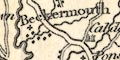
Settlements are marked by blocks, perhaps with a cross
for a church, differentiated by style of labelling.
|
|
| towns |
blocks, perhaps a cross for a church; labelled in upright
block caps, eg:-
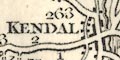
KENDAL / 263 ORTON AMBLESIDE / 276 RAVENGLASS / 284 |
|
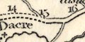
| villages |
blocks, perhaps a cross for a church; labelled in upright
lowercase text, eg:-
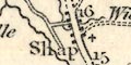
Shap Bampton Gosforth |
|
| hamlets |
block or blocks; labelled in italic lowercase text,
eg:-
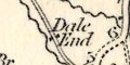
Dale End [in Longsleddale] New Village [Lowther] Stavely This txt labels other features on the map. |
|
| houses |
building; labelled in italic lowercase text, eg:-
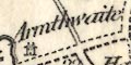
Armathwaite Gilse [N of Orton] |
|
|
|
||
|
roads
road distances toll gates turnpike roads |
A network of roads is drawn by double line, broader or narrower for greater or lesser roads, solid or dotted lines for fenced or unfenced margins? The greater roads have the two lines light bold, which is sometimes used to indicate turnpikes in maps of this period. These roads might have road distances from town to town marked by figures along the route at mile intervals, for examples see the roads radiating from Kendal. On the road north of Grasmere is:- 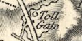
Toll Gate 10 miles south of Keswick on the Ambleside road. |
|
|
|
||
| canals |
A canal is drawn by a triple line, light bold light, from Kendal south to the map edge, the Lancaster and Kendal Canal. |
|
|
|
||
| miscellaneous | ||
|
|
||
| antiquities |
An indeterminate symbol east of Muncaster Hall is
labelled:-
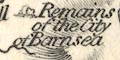
Remains of the City of Barnsea This is presumably the group of settlements and cairns at Barnscar on Birkby Fell. |
|
|
|
||
| stones |
Although the boundary lines do not support it, there is a
label:-
3 Shire Stone where Lancashire, Cumberland and Westmorland meet. |
|
Lakes Guides menu.