 Reynolds 1848

|

|
|
|
item:- JandMN (55) image:- © see bottom of page |
click to enlarge |
|
|
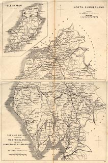
Pair of maps, The Lake District and North Cumberland,
scale about 8 miles to 1 inch, engraved by John Emslie,
published by James Reynolds, 174 Strand, London, 1864.
The Lake District has Westmorland with parts of Cumberland and Lancashire; the north sheet is North Cumberland and has the Isle of Man as an inset on the sheet. Published in a Portable Atlas of England and Wales ... by James Reynolds, 174 Strand, London, 1864. |
||

|
Reynolds 1848 | |
| map feature:- | north point & up is N & scale line & sea plain & coast shaded & rivers & lakes & county & settlements & roads & canals & railways | |
| inscription:- |
printed upper left and right
ISLE OF MAN / NORTH CUMBERLAND |
|
| inscription:- |
printed lower left
THE LAKE DISTRICT / COMPRISING / WESTMORLAND / AND PARTS OF / CUMBERLAND & LANCASHIRE |
|
| scale line:- | 12 miles = 38.0 mm | |
| wxh, sheet:- | 25x18.5cm | |
| wxh, map:- | 225x170mm | |
| scale:- | 1 to 510000 ? (1 to 508214 from scale line) | |
|
|
notes | |