 Lake District, The

|

|
|
|
map type:- Reynolds 1848 |
|
|
|
Maps, The Lake District, and North Cumberland, each scale
about 8 miles to 1 inch, engraved by John Emslie, published
by James Reynolds, 174 Strand, London, 1848; published
1848-64.
The Lake District has Westmorland with parts of Cumberland and Lancashire; the north sheet has part of Cumberland and the Isle of Man as an inset. Published in 'Reynolds's Travelling Atlas of England: with all the Railways and Stations accurately laid down. Constructed from the surveys of the Board of Ordnance, Railway Companies, and other authorities. London: Simpkin, Marshall & Co. Stationer's Court; and James Reynolds, 174, Strand, 1848.' The atlas has title page, index of maps and 32 plates of which some have several counties together; the atlas size is 5 x 7 ins. Published in a 'Portable Atlas of England and Wales; with Tourist Guide to the principal places of interest, fishing streams, finest views and scenery, &c. of each county. Thirty two maps. London: James Reynolds, 174, Strand, W.C.' 1864. In the 1864 edition the border lines, plate numbers and imprints are removed, the numbers re-engraved with a single border line. The plates are used for the geological maps by Reynolds, 1860. |
||
|
(example map JandMN (55))
|
||
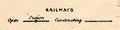
| map feature:- | north point & up is N & scale line & sea plain & coast shaded & rivers & lakes & county & settlements & roads & canals & railways | |
| inscription:- |
printed upper left and right
ISLE OF MAN / NORTH CUMBERLAND |
|
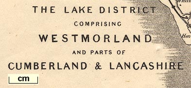
| inscription:- |
printed lower left
THE LAKE DISTRICT / COMPRISING / WESTMORLAND / AND PARTS OF / CUMBERLAND & LANCASHIRE |
|
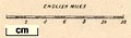
| scale line:- | 12 miles = 38.0 mm | |
| scale:- | 1 to 510000 ? (1 to 508214 from scale line) | |
| wxh, sheet:- | 25x18.5cm | |
| wxh, map:- | 225x170mm | |
| inscription:- |
[Drawn & Engraved by John Emslie] |
|
| inscription:- |
[Published by J. Reynolds, 174, Strand.] |
|
|
||
|
||
| references:- |
Reynolds, James: 1848: Reynolds's Travelling Atlas of
England: Reynolds, James & Simpkin, Marshall and Co
(London) Reynolds, James: 1864: Portable Atlas of England and Wales: (London) |
|
| sources:- |
Chubb 1927 (DXXVI) JandMN Collection |
|
| items seen (illustrated items in bold):- | ||

|
JandMN (55) -- map -- Lake District, The -- North Cumberland | |