 Hall 1822

|

|
|
|
item:- JandMN (36_1) image:- © see bottom of page |
click to enlarge |
|
|
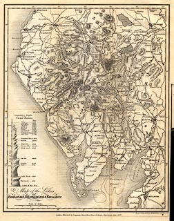
Map of the Lakes of Cumberland, Westmorland and
Lancashire, scale about 5.5 miles to 1 inch, by Sidney Hall,
Bury Street, Bloomsbury, London, published by Longman,
Hurst, Rees, Orme, and Brown, Paternoster Row, London, 1822;
published 1822-49.
Tipped in before the title page of 'A GUIDE THROUGH THE DISTRICT OF THE LAKES IN The North of England, ...' by William Wordsworth, by Hudson and Nicholson, Kendal, Westmorland, and by Longman and Co, Moxon, and Whittaker and Co, London, 5th edn 1835. |
||

|
Hall 1822 | |
| map feature:- | up is N & scale line & lat and long scales & sea areas & sea plain & coast line & coast shaded & rivers & lakes & relief & hill hachuring & table of heights & county & settlements & roads & canals | |
| inscription:- |
printed lower left
Map of the Lakes / OF / Cumberland, Westmorland & Lancashire. |
|
| inscription:- |
printed bottom right and centre
Drawn & Engraved by Sidy. Hall, Bury Strt. Bloomsby. / London, Published by Longman, Hurst, Rees, Orme & Brown, Paternoster Row, 1822. |
|
| scale line:- | 10 miles = 46.2 mm | |
| wxh, sheet:- | 21.5x29cm | |
| wxh, plate:- | 201x255mm | |
| wxh, map:- | 188x236mm | |
| scale:- | 1 to 350000 ? (1 to 348343 from scale line) | |
|
|
notes | |