 Hall 1822

|

|
|

|
back to object record | |
| MAP FEATURES | ||
|
|
||
| folded |
The map is folded and tipped into its guide book facing
the title page.
|
|
|
|
||
|
title
map maker publisher |
Printed lower left:-
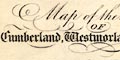
Map of the Lakes OF Cumberland, Westmorland & Lancashire. and printed bottom right and centre:- Drawn & Engraved by Sidy. Hall, Bury Strt. Bloomsby. / London, Published by Longman, Hurst, Rees, Orme & Brown, Paternoster Row, 1822. |
|
|
|
||
|
orientation
up is N |
The map is printed with North at the top of the page.
|
|
|
|
||
|
scale line
scale |
Printed lower left is a:-
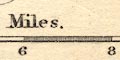
Scale of Miles. chequered in miles to 4, then at 2 mile intervals, labelled 2, 4, 6, 8, 10. The 10 miles = 46.2 mm gives a map scale 1 to 348343 assuming a statute mile. The map scale is about:- 1 to 350000 5.5 miles to 1 inch |
|
|
|
||
|
lat and long
lat and long scales |
Printed in the map borders are scales of latitude and longitude for a rectangular projection; chequered in minutes, labelled at 10 minute intervals. The 3 degree meridian is drawn up and down the map. The map includes from 2d39m to 3d39m West, from 54d1m to 54d43m North; the whole of The Lakes but cutting off Westmorland east of Shap, and Cumberland north of Maryport. |
|
|
|
||
|
sea area
sea plain |
The sea area is plain, and unlabelled.
|
|
|
|
||
|
coast line
coast shaded foreshore lighthouses harbours |
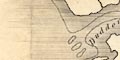
The coast line is shaded for emphasis; two sets of shading are used, one extending a way into the offing. Dotted lines outline foreshore areas, showing the position of the various 'sands' and river channels in estuaries. Some features are labelled, eg:- Duddon Sands Cartmel Wharf Some islands are noticed, some labelled, eg:- Foulney I. Walney Isle Headlands are not generally labelled, but notice the land north of St Bees is labelled:- Heads On St Bees Head there is a tower labelled:- 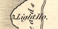
Light Ho. Harbours are not noticed, except the area of the Lancashire Sands labelled:- 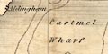
Cartmel Wharf |
|
|
|
||
|
rivers
bridges ferries |
Rivers are drawn by a wiggly line tapering inland from the coast or estuary, some with tributaries. Some of the rivers are labelled, eg:- Kent R. Ehen R. Lowther R. Bridges are implied where a road crosses and interrupts a stream. A few are labelled, eg:- 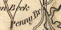
Penny Br Duddon Br Newby Br Roads either side of Windermere lead to the shore, and on the west side is labelled:- Ferry |
|
|
|
||
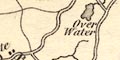
| lakes |
Lakes are drawn in outline with shading, and might be
labelled:-
Ulles Water Bassenthwaite Water Derwent Water Hawes Water Crummock Water Ennerdale Water Wast Water Devock Water Winder Mere Coniston Mere Other lakes are drawn but not labelled, eg:- Loweswater Grasmere Rydal Water Buttermere and smaller tarns for example:- Kentmere Skeggles Water Blea Water [by Harter Fell] Small Water etc. |
|
|
|
||
|
relief
hill hachuring |
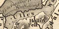
Relief is indicated, quite diagrammatically, by hill
hachuring. While the mountainous nature of the area is made
clear, the actual shape of the relief is not demonstrated
well. Some mountains and hills are labelled, eg:-
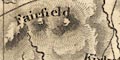
Fairfield Old Man Gable Scaw Fell Pike Potter Fell Harter Fell And some valleys are labelled, eg:- Mardale Eskdale Ennerdale |
|
|
|
||
| table of heights |
Printed lower left is a diagram of hill peaks:-
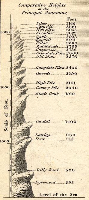
Comparative Heights of the Principal Mountains. giving heights in feet:- Pikes ... 3166 Scawfell ... 3100 Helvellyn ... 3055 Skiddaw ... 3022 Gable ... 2925 Bowfell ...2911 Pillar ... 2893 Saddleback ... 2789 Grassmoor ... 2756 Grisedale Pike ... 2680 Old Man ... 2576 Langdale Pikes ... 2400 Carrock ... 2290 High Pike ... 2101 Cawsey Pike ... 2040 Black Comb ... 1919 Cat Bell ... 1400 Latrigg ... 1160 Dent ... 1115 Scilly Bank ... 500 Egremont ... 293 Level of the Sea |
|
|
|
||
| parks |
Parks are drawn in outline with fence palings, and the
interior area dotted. Some parks are labelled by name, or
the name of a house, eg:-
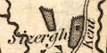
Sizergh Levens Park Troutbeck P. Gowbarrow Parks Lowther House |
|
|
|
||
| county |
County boundaries are a dotted line, if you can see them! They are not drawn where they follow a river, and perhaps missed elsewhere. The county areas are labelled:- CUMBERLAND WESTMORLAND LANCASHIRE |
|
|
|
||
|
settlements
street map |
Settlements are marked by a block, group of blocks, or
perhaps shading between streets within a town,
differentiated by style of labelling. Larger places are
drawn with a simple street plan, for example at Kendal and
more simply at Keswick. The size of settlement is not to be
relied on.
|
|
|
cities
towns |
group of blocks on a street plan; labelled in upright or
italic block caps, eg:-
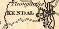
KENDAL KESWICK CARTMEL |
|
|
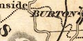
villages
hamlets |
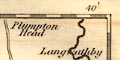
a block or blocks, or nothing; labelled in upright or
italic lowercase, eg:-
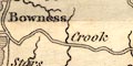
Crook Shap Brougham |
|
|
|
||
|
roads
sands roads |
A network of roads is drawn by double and single lines, for major and minor routes. The minor routes would have been tracks. Some of these will now be metalled roads; others are still tracks for the walker; or maybe disappeared. For example the road off the Kendal to Shap road, at about Watchgate is shown up Longsleddale on the east of the River Sprint; now a metalled, though single track, road. Ignoring errors at the upper end, the route continues past Harter Fell to the head of Mardale; now just a track. And then goes down the northwest side of Haweswater to Bampton; now flooded by the enlarged Haweswater Reservoir, replaced by a metalled road on the southeast shore. 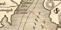
From near Slyne on the Lancaster to Kendal road a dotted track is shown across the Lancaster Sands and Kent Estuary to:- Carter Ho. near Kent Banks. The sands road across Leven Sands and Duddon Sands are also shown. A double dotted line for a track, crosses the Esk Estuary south of Ravenglass. |
|
Lakes Guides menu.