 Map of the Lakes of Cumberland, Westmorland and
Lancashire
Map of the Lakes of Cumberland, Westmorland and
Lancashire

|

|
|
|
map type:- Hall 1822 |
|
|
|
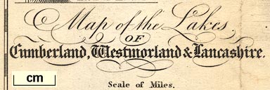
Map of the Lakes of Cumberland, Westmorland and
Lancashire, scale about 5.5 miles to 1 inch, by Sidney Hall,
Bury Street, Bloomsbury, London, published by Longman,
Hurst, Rees, Orme, and Brown, Paternoster Row, London, 1822;
published 1822-49.
Included in the 3rd edition of Wordsworth's guide 'A DESCRIPTION OF THE SCENERY OF THE LAKES IN THE NORTH OF ENGLAND. THIRD EDITION, (NOW FIRST PUBLISHED SEPARATELY) WITH ADDITIONS, AND ILLUSTRATIVE REMARKS UPON THE Scenery of the Alps. BY WILLIAM WORDSWORTH. LONDON: LONGMAN, HURST, REES, ORME, AND BROWN, PATERNOSTER-ROW. 1822.' and in the 4th edition 1823. Included in the 5th edition 'A GUIDE THROUGH THE DISTRICT OF THE LAKES IN The North of England, ...' by William Wordsworth, by Hudson and Nicholson, Kendal, Westmorland now Cumbria, and by Longman and Co, Moxon, and Whitataker and Co, London, 1835. |
||
| see:- | Wordsworth 1810 | |
|
(map example JandMN (36))
|
||
| map feature:- | up is N & scale line & lat and long scales & sea plain & coast line & coast shaded & rivers & lakes & relief & hill hachuring & table of heights & county & settlements & roads & canals | |
| inscription:- |
printed lower left
Map of the Lakes / OF / Cumberland, Westmorland & Lancashire. |
|
| scale line:- | 10 miles = 46.2 mm | |
| scale:- | 1 to 350000 ? | |
| wxh, map:- | 188x236mm | |
|
||
| sources:- |
JandMN Collection |
|
| items seen (illustrated items in bold):- | ||

|
JandMN (36_1) -- map -- Map of the Lakes of Cumberland, Westmorland and Lancashire | |