 Leigh 1830 map

|

|
|
|
item:- JandMN (1_1) image:- © see bottom of page |
click to enlarge |
|
|
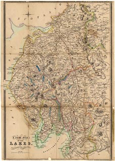
Map, A New Map of the Lakes in Westmoreland Cumberland
Etc, ie the Lake District, scale about 4 miles to 1 inch,
published about 1830.
Inserted in Leigh's Guide to the Lakes and Mountains of Cumberland, Westmorland and Lancashire, by M A Leigh, 3rd edn published by Leigh and Son, 421 Strand, London, 1835. The map has lost its bottom edge, which may have had map maker and engraver information. |
||

|
Leigh 1830 map | |
| map feature:- | compass rose (minimal) & up is N & scale line & lat and long scales & sea plain & coast line & coast tinted & rivers & relief & hill hachuring & parks & county & settlements & roads & canals | |
| inscription:- |
printed title, lower left
A NEW MAP / OF THE / LAKES, / in / WESTMORELAND CUMBERLAND &c. |
|
| scale line:- | 8 miles = 51.3 mm | |
| scale:- | 1 to 250000 ? (1 to 250970 from scale line) | |
| wxh, map:- | 353x517mm | |
|
|
notes | |