 Map History

|

|
|
|

|
start | ||
|
|
previous | ||
|
18th Century It was not until the middle of the 18th century that completely new county surveys were made, carried out with a more scientific approach, and to a larger scale. This was motivated by the generally increasing awareness of the world and the increasing need to satisfy the appetite for knowledge; the two things feeding off each other. There was also the practical motivation of a premium, a prize, offered by the Society of Arts for better maps of counties, from 1759 onwards:- The Society proposes to give a Sum not exceeding one hundred Pounds, as a Gratuitity to any Person or Persons, who shall make an accurate Survey of any County upon the scale of one Inch to a Mile; the Sea Coasts of all Maritime Counties to be laid down together with the Latitudes and Longitudes. Jeffreys and Donald and Yates
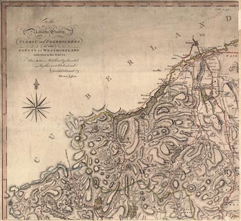 For Westmorland the first 1 inch to 1 mile survey was published by Thomas Jefferys, 1770. At this scale this small county is about 107 x 99 cm, the map is printed on 4 sheets of paper. Cumberland and Lancashire are bigger. It was possible to paste the sheets together on linen to be rolled up hung on a wall; or the sheets could be cut up, sectioned, so that when mounted they fold up neatly into a slip case. This last arrangement is easiest to handle but the gaps between the sections interfere with measurement. For Cumberland the first one inch map was by Thomas Donald, published by Joseph Hodskinson, 1774. The whole map is about 163 x 115 cm, on 6 sheets of paper. For Lancashire north of the sands, now a part of Cumbria, the first one inch map is the north part of the County Palatine of Lancaster, by William Yates, 1786. And for the tiny part of Yorkshire, West Riding, now in Cumbria, see the top left sheet of A Survey of the County of York, by Thomas Jefferys, 1771. Most of the one inch maps, cumbersome and expensive, were reduced and made available in handier, and cheaper, scales. Estate plans, at various large scales, have been drawn since much earlier times; many exist in manuscript only. These plans answer requirements of defining land ownership, enabling land management, and pride of the land owner. They are not considered in this project. In the 18th century there was increasing interest in the accurate measurement of the earth's surface. Local astronomical measurements could fix positions accurately. At a national level the idea of an overall triangulation was growing, so that county maps would 'fit together' at county boundaries to make a map of the country.. Another change in society was the increasing awareness of the landscape by antiquarians, natural scientists and tourists, and maps of this period might include specific symbols for earthworks and so on. One inch maps, by the end of the 18th century, were a valuable tool of local administration much as they are today. This is a significant change in attitude from the early 16th century when the concept of a local map was still unfamiliar. The maps are still not perfect, and it is not strange to have comments by a serious user, Adam Sedgwick, involved in geological fieldwork, complaining about the accuracy of his maps. For examples, notebook 12, 1823:- ... The dyke ranges thro' & has been proved in the mosses towards Ulpha Kirk house. It is probly ye same with ye Wallowbarrow & in ye other directn breaks out above Whinfield ground & is supposed to range to [Mare] Crag. If this be true Donald's map must be very wrong for ye dyke must make a flexure. and notebook 13, 1824:- ... Cross ye moors and see nothing. At top of 1st gill ye [ ] ridge bears Mag N [therefore] ye map is evidently wrong. - go and fish in ye lake / tea / journal. His own copy of the map is annotated with corrections. |
|||
|
|
next | ||
|
|
|||
Lakes Guides menu.