

Click to enlarge
BPQ13.jpg (taken 24.8.2008)

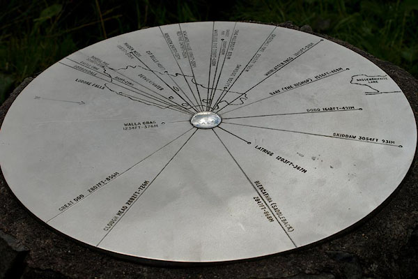
BPQ14.jpg Topograph at the viewpoint.
(taken 24.8.2008)
 goto source
Gentleman's Magazine 1805 p.1122 "... we climbed Castlehead, a pretty tufted hill about half a mile distant from Cockshut. This is a most commanding eminence. Had Mr. Grey, seated on its summit, consented for once to loosen the bandage from his eyes, and contemplate magnificence without terror, we could but faintly conceive the glowing touches of his animated pencil. Directly beneath us lay the town of Keswick, in as much obscurity as we could wish."
 click to enlarge
O80E16.jpg
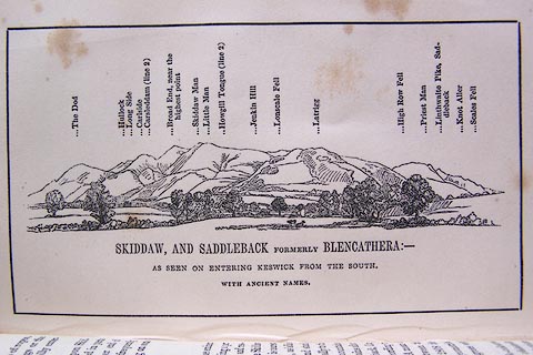
Opposite p.46 of A Descriptive Guide of the English Lakes, by Jonathan Otley, 8th edition, 1849.
printed at bottom:- "SKIDDAW, AND SADDLEBACK FORMERLY BLENCATHERA: - / AS SEEN ON ENTERING KESWICK FROM THE SOUTH. / WITH ANCIENT NAMES."
printed at top:- "The Dod / Hullock / Long Side / Carlside / Carsleddam (line 2) / Broad End, near the highest point / Skiddaw Man / Little Man / Howgill Tongue (line 2) / Jenkin Hill / Lonscale Fell / Latrigg / High Row Fell / Priest Man / Linthwaite Pike, Saddleback / Knot Aller / Scales Fell"
Looking N; 90 degree view, NW to NE.
item:- Armitt Library : A1180.17
Image © see bottom of page
placename:- Castlehead
 goto source
Page 118:- "For an introduction to the beauties of Keswick vale, a good station will be found on Castlehead, which is a wooded rock rising, in the centre of the Derwentwater estate, to the height of 280 feet above the lake. From the Borrowdale road, at one third of a mile from the inn, a path turns off by which the hill is ascended: and from its summit the lake of Derwent is finely displayed, with its numerous bays and islands. Lord's Island, near the shore, was once the residence of the family"
 goto source
Page 119:- "of Derwentwater; the smaller island of Rampsholm lies beyond it; St. Herbert's Isle nearer the middle of the lake; and to the right Vicar's Isle, on which General Peachy has a house. The circumjacent mountains of Borrowdale and Newlands make a fine panorama. At the head of Borrowdale appears Great End Crag, beyond it a part of Scawfell with the highest of the Pikes. Looking through the vale of Newlands, Red Pike, distinguished by its colour, rises over Buttermere. To the eastward, Wanthwaite Crags, and Great Dod, form the end of the mountain range extending from Helvellyn. To the north Skiddaw rises finely, and Saddleback may be seen over the trees. Crosthwaite Church is a good object in the vale, and over the rising ground beyond Bassenthwaite Lake, the mountain Crif Fell in Scotland shews his head. This may be thought too elevated a station for the eye of a painter; but as a general view of the lake, the town, and the valley, it is excellent. Some of the lower stations formerly recommended are rendered less inviting by the too great profusion of wood upon the shores of the lake, and upon its islands; but this rock will always remain sufficiently prominent for a prospect; and its substance offers a study for the geologist."
 click to enlarge
OT2E08.jpg
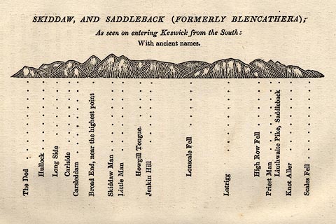
Printed on p.49 of A Concise Description of the English Lakes, by Jonathan Otley, 5th edition, 1834.
printed at top:- "SKIDDAW AND SADDLEBACK (FORMERLY BLENCATHERA); / As seen on entering Keswick from the South: / With ancient names."
printed at bottom:- "The Dod / Hullock / Long Side / Carlside / Carsleddam / Broad End, near the highest point / Skiddaw Man / Little Man / Howgill Tongue / Jenkin Hill / Lonscale Fell / Latrigg / High Row Fell / Priest Man / Linthwaite Pike, Saddleback / Knot Aller / Scales Fell"
item:- JandMN : 48.9
Image © see bottom of page
 click to enlarge
O75E01.jpg
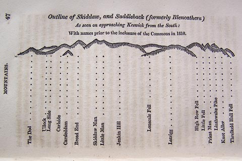
p.47 in A Concise Description of the English Lakes, by Jonathan Otley, 4th edition, 1830.
printed at top:- "Outline View of Skiddaw, and Saddleback (formerly Blencathera) As seen on approaching Keswick from the South: With names prior to the inclosure of the Commons in 1810."
printed at bottom:- "The Dod / Ullock / Long Side / Carleside / Carsleddam / Broad End / Skiddaw Man / Little Man / Jenkin Hill / Lonscale Fell / Latrigg / High Row Fell / Little Fell / Priest Man / Linthwaite Pike / Knot Aller / Threlkeld Hall Fell"
item:- Armitt Library : A1175.2
Image © see bottom of page
placename:- Castlet
 click to enlarge
WTL314.jpg
"Falcon Crag. Barrow House, Mr. Pocklington. Lowdore Waterfall Mountains in Borrowdale. Shepherd's Crag. Castle Crag. Grange. Maiden moor. Rampsholm Id. Lord's Island Brandelow St. Herbert's Isle Catbells Great Robinson Friar's Crag Vale of Newlands Red Pike Rollingend Vicar or Derwent Island Cawsey Pike 2040ft. Barrow Swinside Grisedale Pike 2680ft. Istmus Whinlatter Portinscale Village Thornthwaite Greta River Withorp brows Bassenthwaite Lake Skiddaw Dod / Drawn & Engraved by W. Westall A.R.A. / Keswick Lake, / from Castlet. / Published by Ackermann and Co, 96 Strand."
item:- Armitt Library : A6658.14
Image © see bottom of page
