 Old Cumbria Gazetteer
 |
 |
|
| included in:- |
 Coniston Water Coniston Water |
|
| viewpoint, Beck Leven Foot | ||
| locality:- | Beck Leven Foot | |
| civil parish:- | Coniston (formerly Lancashire) | |
| county:- | Cumbria | |
| locality type:- | viewpoint | |
| 1Km square:- | SD3095 | |
| 10Km square:- | SD39 | |
|
|
||
| evidence:- | descriptive text:- West 1778 (11th edn 1821) placename:- station, Coniston, West 3 |
|
| source data:- | Guide book, A Guide to the Lakes, by Thomas West, published by
William Pennington, Kendal, Cumbria once Westmorland, and in
London, 1778 to 1821. goto source Page 51:- "..." "STATION III. After crossing the common where grows a picturesque yew tree on the right hand, and a small peninsula rushes into the lake on the left, crowned with a single tree, enter the grove, and pass a gate, and bridge that crosses a small rivulet. Look for a fragment of dark-colored rock on the margin of the water, and near it will be found the best stand for the artist to take the finest view on the lake. Looking across the lake, by the south end of the grove that conceals Coniston-hall, and over the cultivated tract that rises behind it, between two swells of rocks, a cataract will meet the eye, issuing from the bosom of the mountains. The side ground on the right is a wooded, sloping rock, and over it the road is catched slanting along. The near foreground is the greatest extent of the lake; and behind the immediate mountains, the Westmorland fells are seen towering to the clouds. This station will be found, by company coming down the lake, at the" goto sourcePage 52:- "circular bay; where the road first joins the level of the water." |
|
|
|
||
| evidence:- | old map:- Crosthwaite 1783-94 (Con) |
|
| source data:- | Map, uncoloured engraving, An Accurate Map of Coniston Lake,
scale about 3 inches to 1 mile, by Peter Crosthwaite, Keswick,
Cumberland, 1788, version published 1809.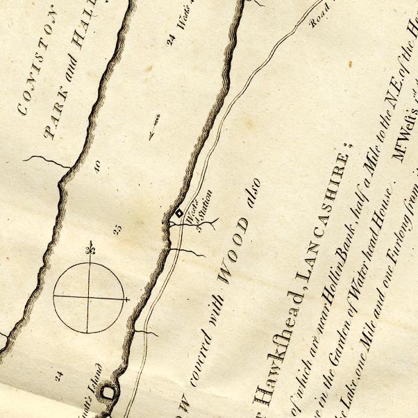 CTESD39C.jpg "West's 3d. Station" square symbol item:- JandMN : 182.5 Image © see bottom of page |
|
|
|
||
| evidence:- | old map:- Crosthwaite 1783-94 (Con) placename:- station, Coniston, West 3 |
|
| source data:- | Series of maps, An Accurate Map of the Matchless Lake of
Derwent, of the Grand Lake of Windermere, of the Beautiful Lake
of Ullswater, of Broadwater or Bassenthwaite Lake, of Coniston
Lake, of Buttermere, Crummock and Loweswater Lakes, and
Pocklington's Island, by Peter Crosthwaite, Kendal, Cumberland
now Cumbria, 1783 to 1794. "West's 3d. Station" about 6 furlongs north of Knott's Island. |
|
|
|
||
| indexing | ||
| person:- | author : West, Thomas |
|
| place:- | Coniston Water | |
| date:- | 1778 |
|
| period:- | 18th century, late | |
| period:- | 1780s | |
| item:- | guide book; Guide to the Lakes |
|
|
|
||
Lakes Guides menu.