 Old Cumbria Gazetteer
 |
 |
|
||||||||||||||||
| Stainmore | ||||||||||||||||||
| civil parish:- | Stainmore (formerly Westmorland) | |||||||||||||||||
| county:- | Cumbria | |||||||||||||||||
| locality type:- | locality | |||||||||||||||||
| locality type:- | valley | |||||||||||||||||
| 10Km square:- | NY81 | |||||||||||||||||
|
|
||||||||||||||||||
| evidence:- | old map:- Paris 1240s placename:- Seinmora |
|||||||||||||||||
| source data:- | Map, version B, northern England, Scotland and part of Wales, by Matthew Paris, 1240s.
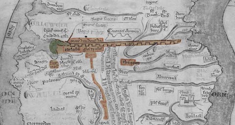 click to enlarge click to enlargePAR2Cm.jpg "Sein / mo / r / a" derived from copyright image, courtesy of Corpus Christi College item:- Corpus Christi, Cambridge : MS16.f4.5 Image © see bottom of page |
|||||||||||||||||
|
|
||||||||||||||||||
| evidence:- | old map:- Mercator 1595 (edn?) placename:- Stanemore |
|||||||||||||||||
| source data:- | Map, hand coloured engraving, Westmorlandia, Lancastria, Cestria
etc, ie Westmorland, Lancashire, Cheshire etc, scale about 10.5
miles to 1 inch, by Gerard Mercator, Duisberg, Germany, 1595,
edition 1613-16. MER5WmdA.jpg "Stanemore" circle item:- Armitt Library : 2008.14.3 Image © see bottom of page |
|||||||||||||||||
|
|
||||||||||||||||||
| evidence:- | old map:- Speed 1611 (Wmd) placename:- Stainmore |
|||||||||||||||||
| source data:- | Map, hand coloured engraving, The Countie Westmorland and
Kendale the Cheif Towne, scale about 2.5 miles to 1 inch, by
John Speed, 1610, published by George Humble, Popes Head Alley,
London, 1611-12.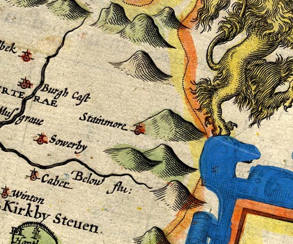 SP14NY81.jpg "Stainmore" circle, tower item:- Armitt Library : 2008.14.5 Image © see bottom of page |
|||||||||||||||||
|
|
||||||||||||||||||
| evidence:- | poem:- Drayton 1612/1622 text placename:- Stanmoor |
|||||||||||||||||
| source data:- | Poem, Poly Olbion, by Michael Drayton, published by published by
John Marriott, John Grismand and Thomas Dewe, and others?
London, part 1 1612, part 2 1622. goto source goto sourcepage 163:- "... Below a bright Nymph, from Stanmore downe doth straine ..." |
|||||||||||||||||
|
|
||||||||||||||||||
| evidence:- | old map:- Morden 1695 (Wmd) placename:- Stainmore Dale |
|||||||||||||||||
| source data:- | Map, hand coloured engraving, Westmorland, scale about 2.5 miles to 1 inch, by Robert
Morden, published by Abel Swale, the Unicorn, St Paul's Churchyard, Awnsham, and John
Churchill, the Black Swan, Paternoster Row, London, 1695.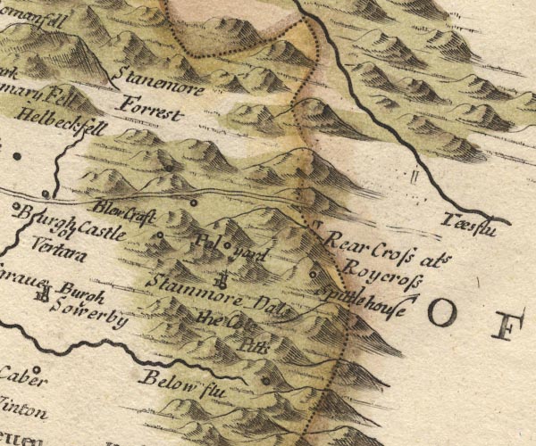 MD10NY81.jpg "Stainmore Dale" Valley between hillocks. item:- JandMN : 24 Image © see bottom of page |
|||||||||||||||||
|
|
||||||||||||||||||
| evidence:- | old map:- Badeslade 1742 placename:- Dale |
|||||||||||||||||
| source data:- | Map, uncoloured engraving, A Map of Westmorland North from
London, scale about 10 miles to 1 inch, with descriptive text,
by Thomas Badeslade, London, engraved and published by William
Henry Toms, Union Court, Holborn, London, 1742. click to enlarge click to enlargeBD12.jpg "Dale" circle, italic lowercase text; village, hamlet or locality item:- Dove Cottage : 2007.38.62 Image © see bottom of page |
|||||||||||||||||
|
|
||||||||||||||||||
| evidence:- | old map:- Simpson 1746 map (Wmd) placename:- Stainmore Dale |
|||||||||||||||||
| source data:- | Map, uncoloured engraving, Westmorland, scale about 8 miles to 1
inch, printed by R Walker, Fleet Lane, London, 1746. SMP2NYV.jpg "Stainmore Dale" Area. item:- Dove Cottage : 2007.38.59 Image © see bottom of page |
|||||||||||||||||
|
|
||||||||||||||||||
| evidence:- | old map:- Bowen and Kitchin 1760 placename:- Stainmore Dale |
|||||||||||||||||
| source data:- | Map, hand coloured engraving, A New Map of the Counties of
Cumberland and Westmoreland Divided into their Respective Wards,
scale about 4 miles to 1 inch, by Emanuel Bowen and Thomas
Kitchin et al, published by T Bowles, Robert Sayer, and John
Bowles, London, 1760.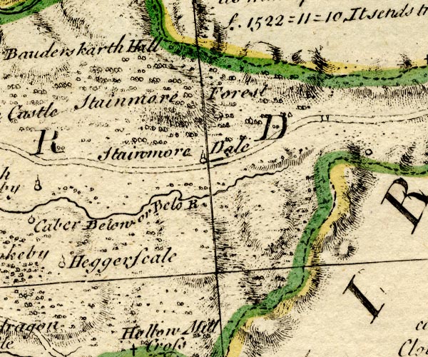 BO18NY81.jpg "Stainmore Dale" circle, tower item:- Armitt Library : 2008.14.10 Image © see bottom of page |
|||||||||||||||||
|
|
||||||||||||||||||
| evidence:- | old map:- Jefferys 1770 (Wmd) placename:- Stainmoor Dale |
|||||||||||||||||
| source data:- | Map, 4 sheets, The County of Westmoreland, scale 1 inch to 1
mile, surveyed 1768, and engraved and published by Thomas
Jefferys, London, 1770.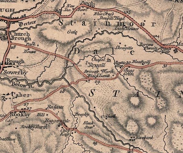 J5NY81SW.jpg "Stainmoor Dale" area item:- National Library of Scotland : EME.s.47 Image © National Library of Scotland |
|||||||||||||||||
|
|
||||||||||||||||||
| evidence:- | old print:- Clarke 1787 placename:- Stanmore |
|||||||||||||||||
| source data:- | circle click to enlarge click to enlargeCL18.jpg "Stanmore" item:- Armitt Library : A6615.12 Image © see bottom of page |
|||||||||||||||||
|
|
||||||||||||||||||
| evidence:- | old map:- Cary 1789 (edn 1805) placename:- Stainmoor Dale |
|||||||||||||||||
| source data:- | Map, uncoloured engraving, Westmoreland, scale about 2.5 miles
to 1 inch, by John Cary, London, 1789; edition 1805.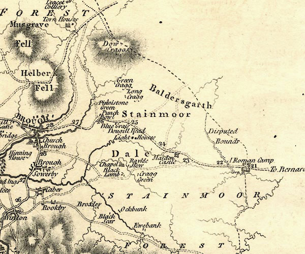 CY24NY81.jpg "Stainmoor Dale" area item:- JandMN : 129 Image © see bottom of page |
|||||||||||||||||
|
|
||||||||||||||||||
| evidence:- | old map:- Aikin 1790 (Wmd) placename:- Stanemore |
|||||||||||||||||
| source data:- | Map, uncoloured engraving, Westmoreland ie Westmorland, scale
about 8.5 miles to 1 inch, by John Aikin, London, 1790. click to enlarge click to enlargeAIK2.jpg "Stanemore" area item:- JandMN : 51 Image © see bottom of page |
|||||||||||||||||
|
|
||||||||||||||||||
| evidence:- | descriptive text:- Otley 1823 (5th edn 1834) placename:- Stainmoor item:- latitude; longitude; lat and long; geology; coal |
|||||||||||||||||
| source data:- | Guide book, A Concise Description of the English Lakes, the
mountains in their vicinity, and the roads by which they may be
visited, with remarks on the mineralogy and geology of the
district, by Jonathan Otley, published by the author, Keswick,
Cumberland now Cumbria, by J Richardson, London, and by Arthur
Foster, Kirkby Lonsdale, Cumbria, 1823; published 1823-49,
latterly as the Descriptive Guide to the English Lakes. goto source Page 79:- "STATION III.- HELVELLYN." "Latitude 54° 31′ 43″ N. Longitude 3° 0′ 24″W. Height 3070 feet." "..." goto sourcePage 163:- "... South-east, coal is found on Stainmoor; ..."
|
|||||||||||||||||
|
|
||||||||||||||||||
| evidence:- | old text:- Gents Mag placename:- Stanemore |
|||||||||||||||||
| source data:- | Magazine, The Gentleman's Magazine or Monthly Intelligencer or
Historical Chronicle, published by Edward Cave under the
pseudonym Sylvanus Urban, and by other publishers, London,
monthly from 1731 to 1922. goto source Gentleman's Magazine 1825 part 1 p.513 From the Compendium of County History:- "Buckle, Sir Cuthbert, Lord Mayor of London in 1598, Stanemore." |
|||||||||||||||||
|
|
||||||||||||||||||
| hearsay:- |
A shepherd from here described the need fire:- |
|||||||||||||||||
| "See that chap with the burning stick - he's carrying the need fire from east to west.
When cattle plague, murrain or rinderpest was sweeping through the townships, a bit
of fire was kindled in the old, old way by rubing two bits of wood together, and the
kindlings were carried to every farm in turn. All stock, horses, cattle, pigs, and
sheep were driven through the smoke of a fire kindled and fed with green wood torn
- not cut - from trees and bushes. Yes, and one old farmer would drive his wife as
had been ailing and his bairns as were not too strong, through the fire and smoke
as well as the stock. They say that the woman and family never ailed a thing after,
but the farmer, because he kept out of the smoke and never coughed, died the same
spring." |
||||||||||||||||||
|
|
||||||||||||||||||
Lakes Guides menu.