 Old Cumbria Gazetteer
 |
 |
|
| roman fort, Bowness-on-Solway | ||
| Maia | ||
| site name:- | Hadrian's Wall | |
| locality:- | Bowness-on-Solway | |
| civil parish:- | Bowness (formerly Cumberland) | |
| county:- | Cumbria | |
| locality type:- | roman fort | |
| locality type:- | roman fort | |
| coordinates:- | NY22236261 (about) | |
| 1Km square:- | NY2262 | |
| 10Km square:- | NY26 | |
|
|
||
| evidence:- | old map:- OS County Series (Cmd 14 4) |
|
| source data:- | Maps, County Series maps of Great Britain, scales 6 and 25
inches to 1 mile, published by the Ordnance Survey, Southampton,
Hampshire, from about 1863 to 1948. "ROMAN FORT (Site of)" |
|
|
|
||
| evidence:- | old map:- Donald 1774 (Cmd) placename:- Blatum Bulgium |
|
| source data:- | Map, hand coloured engraving, 3x2 sheets, The County of Cumberland, scale about 1
inch to 1 mile, by Thomas Donald, engraved and published by Joseph Hodskinson, 29
Arundel Street, Strand, London, 1774.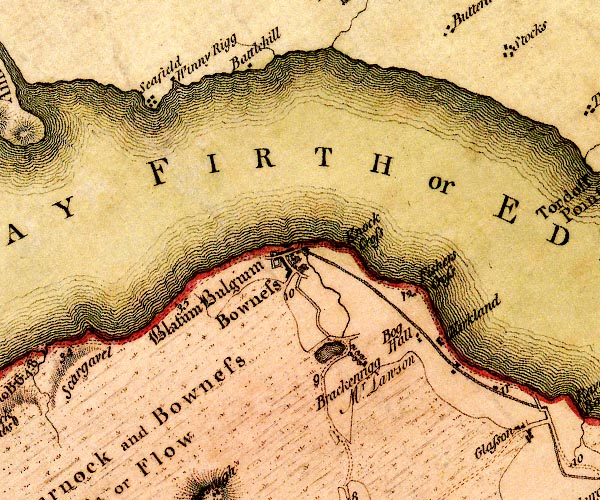 D4NY26SW.jpg "Blatum Bulgium" square within a square; roman fort; English Black Letter item:- Carlisle Library : Map 2 Image © Carlisle Library |
|
|
|
||
| evidence:- | old text:- Camden 1789 (Gough Additions) placename:- Tunnocelum placename:- Blatum Bulgium item:- roman inscription; inscription, roman |
|
| source data:- | Book, Britannia, or A Chorographical Description of the Flourishing Kingdoms of England,
Scotland, and Ireland, by William Camden, 1586, translated from the 1607 Latin edition
by Richard Gough, published London, 1789. goto source goto sourcePage 186:- "..." "... At Bulness he [Horsley] places the Tunnocelum of the Notitia, where the cohors AElia classica, or of marines was stationed. The village now stands as the fort did on a rock or promontory on the edge of the Solway frith. The remains of the wall are considerable not far from hence on the east, but not at all on the west. What Mr. Camden took for its foundations in the water a mile beyond Boulness was rather a small fort. There was at Appleby part of an inscription said to have been found here:" "IMP. M. AVRE TRIVMPHAI PERSAR." "under which Mr. Bainbridge added as a comment:" "MARC AVREL PHILO BLATI BVLGII." goto sourcePage 187:- "Here also was found a small bronze Mercury, or Victory, which came into the hands of John Aglionby, esq; a curious preserver of such things. ..." "... Dr. Gale ... adds in an MS. note on his Itinerary, that when he was at Carlisle 1725 he was told by Mr. Goodman, who had seen them, that there were beyond Boulness ad occasum aestivum the ruins of three castra exploratoria, which commanded all Solway frith. ..." "..." "Sir John [Aglionby?] adds 1739 in his letter to Mr. Gale; "The station has been a large square, fortified with ditches faced with square stones, but only an old square vault remains. ... I cannot think this Tunnocelum, but Blatum Bulgium, which has the greatest affinity with Boulness, ..." |
|
|
|
||
| evidence:- | old text:- Camden 1789 (Gough Additions) |
|
| source data:- | Book, Britannia, or A Chorographical Description of the Flourishing Kingdoms of England,
Scotland, and Ireland, by William Camden, 1586, translated from the 1607 Latin edition
by Richard Gough, published London, 1789. goto source Page 229, quoting Mr Horsley:- "..." ""At BOULNESS, besides coins and other antiquities found there, as also an inscription, a copy whereof is yet at Appleby, there are still the visible remains of a station. The vilage now stands, and the fort has stood, upon a rock or promontory, on the edge of Solway frith; and it is not to be doubted but the church, and what other stone buildings are in the village, have been raised out of its ruins." ""The station must have supplied them sufficiently with what stones they have used in their houses, most of which are made of clay; so that they have not gone to any distance to fetch stones from the wall, the remains of which are considerable not far from this place on the east, but there is no appearance of it to the west. Camden supposes that the wall begun a mile beyond Boulness, from the foundations that appear at low water; but, upon enquiry into this matter, I could not find any thing about it which could be relied on, and therefore am of opinion that it has been the foundation of one of the small forts, which were placed along the shore of the frith, that led him into this mistake. When the tide is out, the river is fordable here. I rode it the evening I was there, but was told it could not be forded below; so that it is probable the wall has terminated in this station."" |
|
|
|
||
| evidence:- | old text:- Camden 1789 placename:- |
|
| source data:- | Book, Britannia, or A Chorographical Description of the Flourishing Kingdoms of England,
Scotland, and Ireland, by William Camden, 1586, translated from the 1607 Latin edition
by Richard Gough, published London, 1789. goto source Page 173:- "... Bulnesse, and it is a very mean village, though it has fortification, and as evidences of antiquity, besides traces of streets and ruined walls, a harbour filled up, and a road said to have run hence along the coast to Elenborrow. ..." |
|
|
|
||
| evidence:- | text:- Rivet and Smith 1979 placename:- Maia placename:- Maium placename:- Mais placename:- Maio placename:- Maiona |
|
| source data:- | The roman fort at Bowness-on-Solway, Cumberland. |
|
|
|
||
Lakes Guides menu.