 Old Cumbria Gazetteer
 |
 |
|
||||||||||||||||||||||||||||||||||||||||||||||||||||||||||||||||||||||||||||||||||||||||||||||||||||||||||||||||||||||||||||||||||||||||||||||||||||||||||||||||||||||||||||||||||||||||||||||||||||||||||||||||||||||||||||||||||||||||||||||||||||||||||||||||||
| road, Kendal to Cockermouth | ||||||||||||||||||||||||||||||||||||||||||||||||||||||||||||||||||||||||||||||||||||||||||||||||||||||||||||||||||||||||||||||||||||||||||||||||||||||||||||||||||||||||||||||||||||||||||||||||||||||||||||||||||||||||||||||||||||||||||||||||||||||||||||||||||||
| Kendal to Cockermouth | ||||||||||||||||||||||||||||||||||||||||||||||||||||||||||||||||||||||||||||||||||||||||||||||||||||||||||||||||||||||||||||||||||||||||||||||||||||||||||||||||||||||||||||||||||||||||||||||||||||||||||||||||||||||||||||||||||||||||||||||||||||||||||||||||||||
| Cockermouth to Kendal | ||||||||||||||||||||||||||||||||||||||||||||||||||||||||||||||||||||||||||||||||||||||||||||||||||||||||||||||||||||||||||||||||||||||||||||||||||||||||||||||||||||||||||||||||||||||||||||||||||||||||||||||||||||||||||||||||||||||||||||||||||||||||||||||||||||
| locality:- | Kendal | |||||||||||||||||||||||||||||||||||||||||||||||||||||||||||||||||||||||||||||||||||||||||||||||||||||||||||||||||||||||||||||||||||||||||||||||||||||||||||||||||||||||||||||||||||||||||||||||||||||||||||||||||||||||||||||||||||||||||||||||||||||||||||||||||||
| civil parish:- | Kendal (formerly Westmorland) | |||||||||||||||||||||||||||||||||||||||||||||||||||||||||||||||||||||||||||||||||||||||||||||||||||||||||||||||||||||||||||||||||||||||||||||||||||||||||||||||||||||||||||||||||||||||||||||||||||||||||||||||||||||||||||||||||||||||||||||||||||||||||||||||||||
| county:- | Cumbria | |||||||||||||||||||||||||||||||||||||||||||||||||||||||||||||||||||||||||||||||||||||||||||||||||||||||||||||||||||||||||||||||||||||||||||||||||||||||||||||||||||||||||||||||||||||||||||||||||||||||||||||||||||||||||||||||||||||||||||||||||||||||||||||||||||
| locality type:- | route | |||||||||||||||||||||||||||||||||||||||||||||||||||||||||||||||||||||||||||||||||||||||||||||||||||||||||||||||||||||||||||||||||||||||||||||||||||||||||||||||||||||||||||||||||||||||||||||||||||||||||||||||||||||||||||||||||||||||||||||||||||||||||||||||||||
| locality:- | Cockermouth | |||||||||||||||||||||||||||||||||||||||||||||||||||||||||||||||||||||||||||||||||||||||||||||||||||||||||||||||||||||||||||||||||||||||||||||||||||||||||||||||||||||||||||||||||||||||||||||||||||||||||||||||||||||||||||||||||||||||||||||||||||||||||||||||||||
| civil parish:- | Cockermouth (formerly Cumberland) | |||||||||||||||||||||||||||||||||||||||||||||||||||||||||||||||||||||||||||||||||||||||||||||||||||||||||||||||||||||||||||||||||||||||||||||||||||||||||||||||||||||||||||||||||||||||||||||||||||||||||||||||||||||||||||||||||||||||||||||||||||||||||||||||||||
| county:- | Cumbria | |||||||||||||||||||||||||||||||||||||||||||||||||||||||||||||||||||||||||||||||||||||||||||||||||||||||||||||||||||||||||||||||||||||||||||||||||||||||||||||||||||||||||||||||||||||||||||||||||||||||||||||||||||||||||||||||||||||||||||||||||||||||||||||||||||
| locality type:- | route | |||||||||||||||||||||||||||||||||||||||||||||||||||||||||||||||||||||||||||||||||||||||||||||||||||||||||||||||||||||||||||||||||||||||||||||||||||||||||||||||||||||||||||||||||||||||||||||||||||||||||||||||||||||||||||||||||||||||||||||||||||||||||||||||||||
|
|
||||||||||||||||||||||||||||||||||||||||||||||||||||||||||||||||||||||||||||||||||||||||||||||||||||||||||||||||||||||||||||||||||||||||||||||||||||||||||||||||||||||||||||||||||||||||||||||||||||||||||||||||||||||||||||||||||||||||||||||||||||||||||||||||||||
| route parts:- |  Kendal to Windermere Windermere to Ambleside Ambleside to Keswick Keswick to Cockermouth Kendal to Windermere Windermere to Ambleside Ambleside to Keswick Keswick to Cockermouth |
|||||||||||||||||||||||||||||||||||||||||||||||||||||||||||||||||||||||||||||||||||||||||||||||||||||||||||||||||||||||||||||||||||||||||||||||||||||||||||||||||||||||||||||||||||||||||||||||||||||||||||||||||||||||||||||||||||||||||||||||||||||||||||||||||||
|
|
||||||||||||||||||||||||||||||||||||||||||||||||||||||||||||||||||||||||||||||||||||||||||||||||||||||||||||||||||||||||||||||||||||||||||||||||||||||||||||||||||||||||||||||||||||||||||||||||||||||||||||||||||||||||||||||||||||||||||||||||||||||||||||||||||||
| evidence:- | old road book:- Ogilby 1675 (edn 1698) |
|||||||||||||||||||||||||||||||||||||||||||||||||||||||||||||||||||||||||||||||||||||||||||||||||||||||||||||||||||||||||||||||||||||||||||||||||||||||||||||||||||||||||||||||||||||||||||||||||||||||||||||||||||||||||||||||||||||||||||||||||||||||||||||||||||
| source data:- | page 45; describing plate 96 "The Road from" "KENDAL to COCKERMOUTH," "..."
"Forward Turnings to be avoided." "At 1'7 the Left acute. 7'5 the Left acute. 31 M. the Right to Melbeak, 35'3 the Right to Skiddow." "..." "FROM Kendal, ascend a Hill, and at 2'6 leave Barnside-V. on the Right. Then bearing to the Left, over an Asc. and Desc. at 5 M. enter Stanlay-V. of 5 F. At 6'1 by Caston-V. on the Right, and 5 F. farther, by Chappel on the Inges on the same hand; pass between Grass-Gate and Broad-Gate 2 Villages: At 7'5 go over a Hill of 7 F. with a Desc. of 3 F. and at the Bottom, by a Wood on the Left." "At 9'5 thro' Winandermere-V. descend St. Kathern's Brow-Hill, and at the Bottom, over a Stone-br. cross a Brook; Winandermere-Water lying by the Road on the Left; which Lake is the biggest in England, and is plentifully supply'd with Fish. Whence over a Stone-Br. and Brook, also by a Wood on the Right, and some Houses; come at 13'2 to Ambleside of 4 F. seated near the said Lake, and having a Mt. on Wednesd. indifferently well stored with Provisions." "Thence several great Hills ranging on both sides of the Road for some M. pass thro' Ridal-P. and over a Br. and Brook, leaving Ridal-Hall on the Right. At 14'7 thro' Ridal-V. over an Asc. and Desc. by Gresmere-Ch. on the Left, cross some Brooks and ascend a Hill of 8 F. near Gresmere-Hill of a great height, on the Left: At 19'6 over a Stone-Br. and Brook, enter Cumberland; where on the Left, is a great heap of Stones call'd Dunmail-Raise-Stones, suppos'd to have been cast up by Dunmail K. of Cumberland for the Bounds of his Kingdom." "Thence by Wyburn-Chap. and Thurlspot-V. on the Right, and Wyburn-Brook on the Left; at 25 M. cross Smarthods-Stone-Br. over Thurlemire flv. and leave the Hills on the Right, which lye along the Road on the Left, to 27'2. There over a Brook, go up a Hill, and at 28'2 thro' Cust-V. Then descending pass thro' Cartherit-V. and at 29'4 to Keswick of about 2 F. on the Road, but more transverse, and on Thurlemire flv. at its Influx into the Darwen. 'Twas a Town of good nore in former Time, now much decay'd; yet it has a Market on Saturdays." "From Keswick, over a Wooden-Br. cross the said Thurlemire, by other great Hills along the Road on the Right and Left; Derwen-flv. running between the Road and the Hills on the Left. Then by Crosthwate-Ch. on the Left, and Milbeck-Hall on the Right; at 33'1 pass thro' Little Crosthwate-V. afterwards by Basin-Thwate-V. on the Left, and the Chap. on the Right: at 37 M. bear to the Left; leave Colebeck and Armanthwate on the Right, and at 38 M. over a Wooden-Br. cross the said Darwen. At 38'4 go thro' Lawbercus-V. and at 39'2 Lawfield-V. Where, over a Hill of 1 M. descend 5 F. and at 43'4 enter Cockermouth, on Derwen and Coker flv. a place of good account, with a fair Ch. and strong Castle. As a Borough-Town it elects Parl-Men, and has a Mt. on Mond. with 2 Fairs." item:- private collection : 367 Image © see bottom of page |
|||||||||||||||||||||||||||||||||||||||||||||||||||||||||||||||||||||||||||||||||||||||||||||||||||||||||||||||||||||||||||||||||||||||||||||||||||||||||||||||||||||||||||||||||||||||||||||||||||||||||||||||||||||||||||||||||||||||||||||||||||||||||||||||||||
|
|
||||||||||||||||||||||||||||||||||||||||||||||||||||||||||||||||||||||||||||||||||||||||||||||||||||||||||||||||||||||||||||||||||||||||||||||||||||||||||||||||||||||||||||||||||||||||||||||||||||||||||||||||||||||||||||||||||||||||||||||||||||||||||||||||||||
| evidence:- | old map:- Ogilby 1675 (plate 96) |
|||||||||||||||||||||||||||||||||||||||||||||||||||||||||||||||||||||||||||||||||||||||||||||||||||||||||||||||||||||||||||||||||||||||||||||||||||||||||||||||||||||||||||||||||||||||||||||||||||||||||||||||||||||||||||||||||||||||||||||||||||||||||||||||||||
| source data:- | Road strip map, hand coloured engraving, the Road from Kendal to
Cockermouth, and the Road from Egremond to Carlisle, scale about
1 inch to 1 mile, by John Ogilby, London, 1675.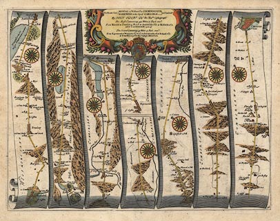 click to enlarge click to enlargeOG96.jpg "The Roads from KENDAL in Westmorld. to COCKERMOUTH in Cumberld." item:- JandMN : 22 Image © see bottom of page |
|||||||||||||||||||||||||||||||||||||||||||||||||||||||||||||||||||||||||||||||||||||||||||||||||||||||||||||||||||||||||||||||||||||||||||||||||||||||||||||||||||||||||||||||||||||||||||||||||||||||||||||||||||||||||||||||||||||||||||||||||||||||||||||||||||
|
|
||||||||||||||||||||||||||||||||||||||||||||||||||||||||||||||||||||||||||||||||||||||||||||||||||||||||||||||||||||||||||||||||||||||||||||||||||||||||||||||||||||||||||||||||||||||||||||||||||||||||||||||||||||||||||||||||||||||||||||||||||||||||||||||||||||
| evidence:- | old map:- Berry 1679 |
|||||||||||||||||||||||||||||||||||||||||||||||||||||||||||||||||||||||||||||||||||||||||||||||||||||||||||||||||||||||||||||||||||||||||||||||||||||||||||||||||||||||||||||||||||||||||||||||||||||||||||||||||||||||||||||||||||||||||||||||||||||||||||||||||||
| source data:- | Road map, diagram, The Grand Roads of England, engraved by John
Rich, made and published by William Berry, at the Sign of the
Globe, London, 1679. from Kendal 4 miles to Stanlay 3 Winandermere 3 Ambleside Wednesday 1 Ridale, Westmorland then 5 to Wiburn~ Chapel 2 Thirlspot 3 Cust 1 Keswick Saturday 2 Little Crossthw: 4 Lawbarcus 4 Cockermouth Monday, Cumberland |
|||||||||||||||||||||||||||||||||||||||||||||||||||||||||||||||||||||||||||||||||||||||||||||||||||||||||||||||||||||||||||||||||||||||||||||||||||||||||||||||||||||||||||||||||||||||||||||||||||||||||||||||||||||||||||||||||||||||||||||||||||||||||||||||||||
|
|
||||||||||||||||||||||||||||||||||||||||||||||||||||||||||||||||||||||||||||||||||||||||||||||||||||||||||||||||||||||||||||||||||||||||||||||||||||||||||||||||||||||||||||||||||||||||||||||||||||||||||||||||||||||||||||||||||||||||||||||||||||||||||||||||||||
| evidence:- | old map:- Morden 1695 (EW) |
|||||||||||||||||||||||||||||||||||||||||||||||||||||||||||||||||||||||||||||||||||||||||||||||||||||||||||||||||||||||||||||||||||||||||||||||||||||||||||||||||||||||||||||||||||||||||||||||||||||||||||||||||||||||||||||||||||||||||||||||||||||||||||||||||||
| source data:- | Map, hand coloured engraving, England, including Wales, scale
about 27 miles to 1 inch, by Robert Morden, published by Abel
Swale Awnsham and John Churchil, London, about 1695. click to enlarge click to enlargeMRD3Cm.jpg double line; road item:- JandMN : 339 Image © see bottom of page |
|||||||||||||||||||||||||||||||||||||||||||||||||||||||||||||||||||||||||||||||||||||||||||||||||||||||||||||||||||||||||||||||||||||||||||||||||||||||||||||||||||||||||||||||||||||||||||||||||||||||||||||||||||||||||||||||||||||||||||||||||||||||||||||||||||
|
|
||||||||||||||||||||||||||||||||||||||||||||||||||||||||||||||||||||||||||||||||||||||||||||||||||||||||||||||||||||||||||||||||||||||||||||||||||||||||||||||||||||||||||||||||||||||||||||||||||||||||||||||||||||||||||||||||||||||||||||||||||||||||||||||||||||
| evidence:- | old text:- Ogilby 1699 (edn 1712) |
|||||||||||||||||||||||||||||||||||||||||||||||||||||||||||||||||||||||||||||||||||||||||||||||||||||||||||||||||||||||||||||||||||||||||||||||||||||||||||||||||||||||||||||||||||||||||||||||||||||||||||||||||||||||||||||||||||||||||||||||||||||||||||||||||||
| source data:- | Road book, itineraries and map, The Traveller's Guide, by John
Ogilby, published by Abel Swall, Tim Child, White Hart, and R
Knaplock, the Angel and Crown, St Paul's Churchyard, London,
1699. OGY7p178.txt page 178 Distances from Kendal "The Roads from" "KENDAL to COCKERMOUTH," "And from Egrimond to CARLISLE." "Westmoreland and Cumberland include the Road, and the Thurle, Darwen, Coker, Eln, Wampul and Cauda, are the chief Rivers cross'd over. This Road, in general, is as bad as any in England, being very hilly, stony and moorish." "Forward Turnings to be avoided." "At 1'7 The Left acute: 7'5 The Left acute. 31M. The Right to Melbeak. 35'3 The Right to Skiddow." "In the Road to CARLISLE." "At the End of Egrimond, the Left to Whitehaven. 5'1 The Right acute. 6'1 The Right to Keswick. 7'3 The Right acute. 8'2 The Left acute. 15'3 The Left to Bridkirk. 16'6 The Right acute. 22'6 The Left to Blin-Rosset. 31'2 The Left acute." "FROM Kendal, ascend a Hill, and at 2'6 leave Barnside V. on the Right; then bearing to the Left, over an Asc. and Desc. at 5M. enter Stanley V. of 5F. At 6'1 by Caston V. on the Right, and 5F. farther, by Chappel on the Inges, on the same hand; pass between Grass-Gate and Broad-Gate, 2 Villages. At 7'5 go over a Hill of 7F. with a Desc. of 3F. and at the Bottom, by a Wood, on the Left." "At 9'5 thro' Winandermere V. descend St. Kathern's Brow-hill, and at the Bottom, over a Stone Br. cross a Brook; Winandermere Water lying by the Road on the Left; which Lake is the biggest in England, and is plentifully supply'd with Fish. Whence over a Stone Br. and Brook, also by a Wood on the Right, and some Houses, come at 13'2 to Ambleside of 4F. seated near the said Lake, and having a Mt. on Wednesd. indifferently well stored with Provisions." "Thence several great Hills ranging on both sides of the Road for some M. pass thro' Ridal P. and over a Br. and Brook, leaving Ridal-hall on the Right, at 14'7" OGY7p179.txt page 179 "thro' Ridal V. over an Asc. and Desc. by Gresmere Ch. on the Left, cross some Brooks, and ascend a Hill of 8F. near Gresmere hill of a great height, on the Left. At 19'6 over a Stone Br. and Brook, enter Cumberland; where, on the Left, is a great heap of Stones call'd Dunmail Raise-Stones, suppos'd to have been cast up by Dunmail K. of Cumberland, for the Bounds of his Kingdom." "Hence by Wyburn Chap. and Thurlspot V. on the Right, and Wyburn Brook on the Left; at 25M. cross Smathods Stone Br. over Thurlemire flv. and leave the Hills on the Right, which lye along the Road on the Left to 27'2. There over a Brook, go up a Hill, and at 28'2 thro' Cust. V. Then descending, pass thro' Cartherit V. and at 29'4 to Keswick of about 2F. on the Road, but more transverse; and on Thurlemire flv. as its Influx into the Darwen. 'Twas a Town of good Note in former Time, now much decay'd; yet it has a Market on Saturdays." "From Keswick, over a Wooden Br. cross the said Thurlemire, by other great Hills along the Road on the Right and Left; Derwen flv. running between the Road and the Hills on the Left.. Then by Crosthwate Ch. on the Left, and Milbeck-hall on the Right, at 33'1 pass thro' Little Crosthwate V. afterwards by Basin-Thwate V. on the Left, and the Chap. on the Right. At 37M. bear to the Left; leave Colbeck and Armanthwate on the Right, and at 38M. over a Wooden Br. cross the said Darwen. At 38'4 go thro' Lawbercus V. and at 39'2 Lawfield V. Where, over a Hill of 1M. descend 5F. and at 43'4 enter Cockermouth, on Derwen and Coker flv. a Place of good Account, with a fair Ch. and strong Castle. As a Borough-Town it elects Parl. Men, and has a Mt.on Mond. with 2 Fairs." OGY7p250.txt page 250 "..." "The Roads from KENDAL in Westmoreland to COCKERMOUTH ..."
|
|||||||||||||||||||||||||||||||||||||||||||||||||||||||||||||||||||||||||||||||||||||||||||||||||||||||||||||||||||||||||||||||||||||||||||||||||||||||||||||||||||||||||||||||||||||||||||||||||||||||||||||||||||||||||||||||||||||||||||||||||||||||||||||||||||
|
|
||||||||||||||||||||||||||||||||||||||||||||||||||||||||||||||||||||||||||||||||||||||||||||||||||||||||||||||||||||||||||||||||||||||||||||||||||||||||||||||||||||||||||||||||||||||||||||||||||||||||||||||||||||||||||||||||||||||||||||||||||||||||||||||||||||
| evidence:- | old strip map:- Senex 1719 (plate 96/Roads) |
|||||||||||||||||||||||||||||||||||||||||||||||||||||||||||||||||||||||||||||||||||||||||||||||||||||||||||||||||||||||||||||||||||||||||||||||||||||||||||||||||||||||||||||||||||||||||||||||||||||||||||||||||||||||||||||||||||||||||||||||||||||||||||||||||||
| source data:- | Strip map, road map, The Road from Kendal in Westmorel to Cockermouth and The Road
from Egremond to Carlisle in Cumberland, by John Senex, The Globe, Salisbury Court,
Fleet Street, London, 1719.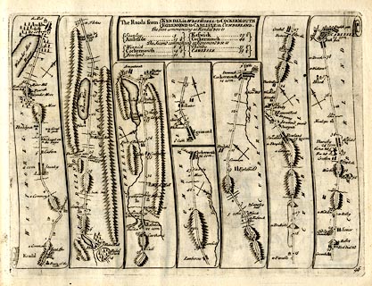 click to enlarge click to enlargeSEN5M5.jpg Plate 96 in An Actual Survey of all the Principal Roads of England and Wales. printed at plain cartouche, upper centre:- "The Roads from / KENDAL in WESTMOREL: to COCKERMOUTH / EGREMOND to CARLISLE in CUMBERLAND. / The first commencing at Kendal & so to / Stanley 5 / Amleside 13¼ / Keswick 29½ / Cockermouth 44 / The second commencing at Egremond & so to / Winnick 6¼ / Cockermouth 14¼ / Bowland 21 / Thursby 33¼ / CARLISLE 39¼" printed at bottom right:- "96" item:- private collection : 272.5 Image © see bottom of page |
|||||||||||||||||||||||||||||||||||||||||||||||||||||||||||||||||||||||||||||||||||||||||||||||||||||||||||||||||||||||||||||||||||||||||||||||||||||||||||||||||||||||||||||||||||||||||||||||||||||||||||||||||||||||||||||||||||||||||||||||||||||||||||||||||||
|
|
||||||||||||||||||||||||||||||||||||||||||||||||||||||||||||||||||||||||||||||||||||||||||||||||||||||||||||||||||||||||||||||||||||||||||||||||||||||||||||||||||||||||||||||||||||||||||||||||||||||||||||||||||||||||||||||||||||||||||||||||||||||||||||||||||||
| evidence:- | old map:- Bowen 1720 (plate 261) |
|||||||||||||||||||||||||||||||||||||||||||||||||||||||||||||||||||||||||||||||||||||||||||||||||||||||||||||||||||||||||||||||||||||||||||||||||||||||||||||||||||||||||||||||||||||||||||||||||||||||||||||||||||||||||||||||||||||||||||||||||||||||||||||||||||
| source data:- | Road strip map, uncoloured engraving, pl.261, the end of the
road from Kendal to Cockermouth and the road from Egremont to
Carlisle, scale about 2 miles to 1 inch, published by Emanuel
Bowen, St Katherines, London, 1720.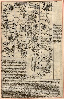 click to enlarge click to enlargeB261.jpg The Road from Kendal to Cockermouth - from Kendal on past Keswick, Cumberland. Places labelled are:- Laubercus a Village / 39, Laufield / 40 / Mountains / 41 ... 42 / 43, a Moor / Cockermouth, Cocker Flu, Derwen Flu item:- Dove Cottage : Lowther.36 Image © see bottom of page |
|||||||||||||||||||||||||||||||||||||||||||||||||||||||||||||||||||||||||||||||||||||||||||||||||||||||||||||||||||||||||||||||||||||||||||||||||||||||||||||||||||||||||||||||||||||||||||||||||||||||||||||||||||||||||||||||||||||||||||||||||||||||||||||||||||
|
|
||||||||||||||||||||||||||||||||||||||||||||||||||||||||||||||||||||||||||||||||||||||||||||||||||||||||||||||||||||||||||||||||||||||||||||||||||||||||||||||||||||||||||||||||||||||||||||||||||||||||||||||||||||||||||||||||||||||||||||||||||||||||||||||||||||
| evidence:- | old map:- Bowen 1720 (plate 260) |
|||||||||||||||||||||||||||||||||||||||||||||||||||||||||||||||||||||||||||||||||||||||||||||||||||||||||||||||||||||||||||||||||||||||||||||||||||||||||||||||||||||||||||||||||||||||||||||||||||||||||||||||||||||||||||||||||||||||||||||||||||||||||||||||||||
| source data:- | Road strip map, uncoloured engraving, pl.260, The Road from
Kendal to Cockermouth, scale about 2 miles to 1 inch, with
sections in Westmorland and Cumberland, published by Emanuel
Bowen, St Katherines, London, 1720.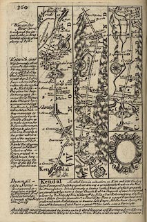 click to enlarge click to enlargeB260.jpg The Road from Kendal to Cockermouth - from Kendal on past Keswick, Cumberland. Places labelled are:- Kendal, a Com~on, The Castle, Lunt Flu / 1 ... 2 / Barnside on right / 3 ... 5 / Stanley / 6, Caston / Chappel on ye Inges on right / 7 / Grass Gate on right?, Broad Gate on left? / 8 / Winandermere / 9 / a Water Mill / 10 ... Winandermere Water on the left ... 13 / Ambleside, The Hall / 14 / Ridal Park both sides of the road, Ridal Hall on right / Ridal, Smiths Shop, 15 ... 19 / Grasmere Hill, enter Cumberland, Dunmail Raise Stones drawn by 6 upstanding stones on left / 20 / Wibourn Chappel / 21 / 22, Wibourn Water, 23 / Thurlspot / 24 ... Smathods Bridge over Thurlmire Flubius ... 28 / Cust / 29, Cartherit / Keswick, a Wood Br. over Thurlemire Flu / 30, a turning to Cockermout ye worst way, a Smiths shop, Crosthwate on left / 31 / Milbeck Hall on right / 32 ... 33 / Little Crosthwate / part of Basinthwate / 34 ... 35 / part of Basinthwate / 36, Basinthwate on right / Birthut Wood on right / 37 / Cole: Beck / 38, Armanthwate item:- private collection : 1.260 Image © see bottom of page |
|||||||||||||||||||||||||||||||||||||||||||||||||||||||||||||||||||||||||||||||||||||||||||||||||||||||||||||||||||||||||||||||||||||||||||||||||||||||||||||||||||||||||||||||||||||||||||||||||||||||||||||||||||||||||||||||||||||||||||||||||||||||||||||||||||
|
|
||||||||||||||||||||||||||||||||||||||||||||||||||||||||||||||||||||||||||||||||||||||||||||||||||||||||||||||||||||||||||||||||||||||||||||||||||||||||||||||||||||||||||||||||||||||||||||||||||||||||||||||||||||||||||||||||||||||||||||||||||||||||||||||||||||
| evidence:- | old map:- Bowen 1720 (plate 259) |
|||||||||||||||||||||||||||||||||||||||||||||||||||||||||||||||||||||||||||||||||||||||||||||||||||||||||||||||||||||||||||||||||||||||||||||||||||||||||||||||||||||||||||||||||||||||||||||||||||||||||||||||||||||||||||||||||||||||||||||||||||||||||||||||||||
| source data:- | Map, uncoloured engraving, pl.259, Cumberland, scale about 16.5
miles to 1 inch, published by Emanuel Bowen, St Katherines,
London, 1720.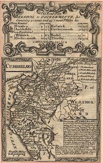 click to enlarge click to enlargeB259.jpg Plate 259 has the title cartouche for:- "The Roads from KENDAL to COCKERMOUTH, &c. Containing 32 Comp. and 43'7 measd. Miles &c." and a table of distances, computed and measured miles in miles'furlongs, which includes, from Kendal:- "Stanley 4 / 5'3" "Ambleside 10 / 13'3" "Keswick 22 / 29'5" "Cockermout 32 / 43'7" and from Egrimond "Winnick 5 / 6'3" "Cockermout 10 / 14'1" "Bodel 15 / 21" "Thursby 24 / 33'4" "CARLISLE 29 / 39'4" item:- Dove Cottage : Lowther.35 Image © see bottom of page |
|||||||||||||||||||||||||||||||||||||||||||||||||||||||||||||||||||||||||||||||||||||||||||||||||||||||||||||||||||||||||||||||||||||||||||||||||||||||||||||||||||||||||||||||||||||||||||||||||||||||||||||||||||||||||||||||||||||||||||||||||||||||||||||||||||
|
|
||||||||||||||||||||||||||||||||||||||||||||||||||||||||||||||||||||||||||||||||||||||||||||||||||||||||||||||||||||||||||||||||||||||||||||||||||||||||||||||||||||||||||||||||||||||||||||||||||||||||||||||||||||||||||||||||||||||||||||||||||||||||||||||||||||
| evidence:- | old road book:- Morgan 1759 |
|||||||||||||||||||||||||||||||||||||||||||||||||||||||||||||||||||||||||||||||||||||||||||||||||||||||||||||||||||||||||||||||||||||||||||||||||||||||||||||||||||||||||||||||||||||||||||||||||||||||||||||||||||||||||||||||||||||||||||||||||||||||||||||||||||
| source data:- | MG01p073.txt page 73
Image © see bottom of page |
|||||||||||||||||||||||||||||||||||||||||||||||||||||||||||||||||||||||||||||||||||||||||||||||||||||||||||||||||||||||||||||||||||||||||||||||||||||||||||||||||||||||||||||||||||||||||||||||||||||||||||||||||||||||||||||||||||||||||||||||||||||||||||||||||||
|
|
||||||||||||||||||||||||||||||||||||||||||||||||||||||||||||||||||||||||||||||||||||||||||||||||||||||||||||||||||||||||||||||||||||||||||||||||||||||||||||||||||||||||||||||||||||||||||||||||||||||||||||||||||||||||||||||||||||||||||||||||||||||||||||||||||||
| evidence:- | old map:- Kitchin 1767 (plate 84) |
|||||||||||||||||||||||||||||||||||||||||||||||||||||||||||||||||||||||||||||||||||||||||||||||||||||||||||||||||||||||||||||||||||||||||||||||||||||||||||||||||||||||||||||||||||||||||||||||||||||||||||||||||||||||||||||||||||||||||||||||||||||||||||||||||||
| source data:- | Road strip map, uncoloured engraving, The Road from Kendal to
Cockermouth, and The Road from Egremont to Carlisle, in
Kitchin's Post Chaise Companion, by Thomas Kitchin, published by
Robert Sayer, 53 Fleet Street, John Bowles, Cornhill, and
Carington Bowles, St Paul's Church Yard, London, 1767.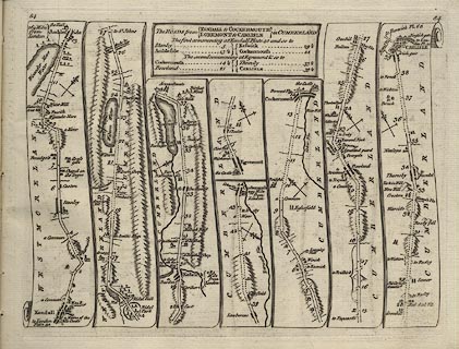 click to enlarge click to enlargeK084.jpg item:- Hampshire Museums : FA1999.138.84 Image © see bottom of page |
|||||||||||||||||||||||||||||||||||||||||||||||||||||||||||||||||||||||||||||||||||||||||||||||||||||||||||||||||||||||||||||||||||||||||||||||||||||||||||||||||||||||||||||||||||||||||||||||||||||||||||||||||||||||||||||||||||||||||||||||||||||||||||||||||||
|
|
||||||||||||||||||||||||||||||||||||||||||||||||||||||||||||||||||||||||||||||||||||||||||||||||||||||||||||||||||||||||||||||||||||||||||||||||||||||||||||||||||||||||||||||||||||||||||||||||||||||||||||||||||||||||||||||||||||||||||||||||||||||||||||||||||||
| evidence:- | old map:- Jefferys 1770 |
|||||||||||||||||||||||||||||||||||||||||||||||||||||||||||||||||||||||||||||||||||||||||||||||||||||||||||||||||||||||||||||||||||||||||||||||||||||||||||||||||||||||||||||||||||||||||||||||||||||||||||||||||||||||||||||||||||||||||||||||||||||||||||||||||||
| source data:- | Map, 4 sheets, The County of Westmoreland, scale 1 inch to 1
mile, surveyed 1768, and engraved and published by Thomas
Jefferys, London, 1770. J55193G.jpg road item:- National Library of Scotland : EME.s.47 Image © National Library of Scotland |
|||||||||||||||||||||||||||||||||||||||||||||||||||||||||||||||||||||||||||||||||||||||||||||||||||||||||||||||||||||||||||||||||||||||||||||||||||||||||||||||||||||||||||||||||||||||||||||||||||||||||||||||||||||||||||||||||||||||||||||||||||||||||||||||||||
|
|
||||||||||||||||||||||||||||||||||||||||||||||||||||||||||||||||||||||||||||||||||||||||||||||||||||||||||||||||||||||||||||||||||||||||||||||||||||||||||||||||||||||||||||||||||||||||||||||||||||||||||||||||||||||||||||||||||||||||||||||||||||||||||||||||||||
| evidence:- | old strip map:- Jeffery 1775 (pl.82/Roads) |
|||||||||||||||||||||||||||||||||||||||||||||||||||||||||||||||||||||||||||||||||||||||||||||||||||||||||||||||||||||||||||||||||||||||||||||||||||||||||||||||||||||||||||||||||||||||||||||||||||||||||||||||||||||||||||||||||||||||||||||||||||||||||||||||||||
| source data:- | Strip map, road map, From Kendall to Cockermouth and From Egremont to Carlisle, by
Thomas Jefferys, published by R Sayer and J Bennett, 53 Fleet Street, London, 1775.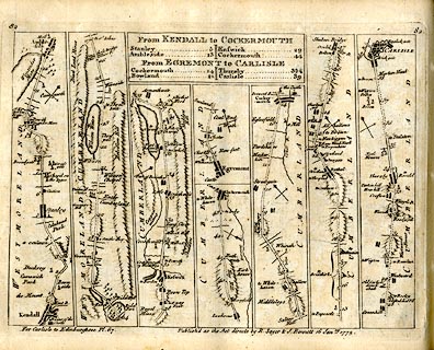 click to enlarge click to enlargeJEF6M5.jpg Plate 87 in Jefferys's Itinerary or Travellers Companion. printed at plain cartouche, upper centre:- "From KENDALL to COCKERMOUTH / Stanley 5 / Ambleside 13 / Keswick 29 / Cockermouth 44 / From EGREMONT to CARLISLE / Cockermouth 14 / Bowland 21 / Thursby 33½/ Carlisle 39" printed at top left and right:- "67 / 67" printed at bottom right of centre:- "Publish'd as the Acts directs by R. Sayer &I. Bennett 16 Janry. 1775." item:- private collection : 271.5 Image © see bottom of page |
|||||||||||||||||||||||||||||||||||||||||||||||||||||||||||||||||||||||||||||||||||||||||||||||||||||||||||||||||||||||||||||||||||||||||||||||||||||||||||||||||||||||||||||||||||||||||||||||||||||||||||||||||||||||||||||||||||||||||||||||||||||||||||||||||||
|
|
||||||||||||||||||||||||||||||||||||||||||||||||||||||||||||||||||||||||||||||||||||||||||||||||||||||||||||||||||||||||||||||||||||||||||||||||||||||||||||||||||||||||||||||||||||||||||||||||||||||||||||||||||||||||||||||||||||||||||||||||||||||||||||||||||||
| evidence:- | descriptive text:- Otley 1823 (5th edn 1834) item:- road distances; itinerary |
|||||||||||||||||||||||||||||||||||||||||||||||||||||||||||||||||||||||||||||||||||||||||||||||||||||||||||||||||||||||||||||||||||||||||||||||||||||||||||||||||||||||||||||||||||||||||||||||||||||||||||||||||||||||||||||||||||||||||||||||||||||||||||||||||||
| source data:- | Guide book, A Concise Description of the English Lakes, the
mountains in their vicinity, and the roads by which they may be
visited, with remarks on the mineralogy and geology of the
district, by Jonathan Otley, published by the author, Keswick,
Cumberland now Cumbria, by J Richardson, London, and by Arthur
Foster, Kirkby Lonsdale, Cumbria, 1823; published 1823-49,
latterly as the Descriptive Guide to the English Lakes. goto source goto sourcePage 91:- "GENERAL DIRECTIONS:" "WITH NOTICES OF THE VARIOUS OBJECTS PASSED IN EACH ROUTE." "STAGES."
|
|||||||||||||||||||||||||||||||||||||||||||||||||||||||||||||||||||||||||||||||||||||||||||||||||||||||||||||||||||||||||||||||||||||||||||||||||||||||||||||||||||||||||||||||||||||||||||||||||||||||||||||||||||||||||||||||||||||||||||||||||||||||||||||||||||
|
|
||||||||||||||||||||||||||||||||||||||||||||||||||||||||||||||||||||||||||||||||||||||||||||||||||||||||||||||||||||||||||||||||||||||||||||||||||||||||||||||||||||||||||||||||||||||||||||||||||||||||||||||||||||||||||||||||||||||||||||||||||||||||||||||||||||
| evidence:- | old strip map:- Smith 1826 (Roads/Cum) |
|||||||||||||||||||||||||||||||||||||||||||||||||||||||||||||||||||||||||||||||||||||||||||||||||||||||||||||||||||||||||||||||||||||||||||||||||||||||||||||||||||||||||||||||||||||||||||||||||||||||||||||||||||||||||||||||||||||||||||||||||||||||||||||||||||
| source data:- | Strip map, pp.85-87, including To Kendal by Halifax and Settle, continued to Keswick
etc, published by Charles Smith and Son, 172 Strand, London, 1st edn 1826.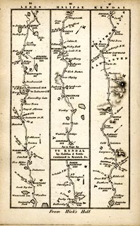 click to enlarge click to enlargeSM22M3.jpg From Settle, Lancashire; through Kirkby Lonsdale to Kendal, Westmorland; and other routes. Included in Smith's Pocket New Companion to the Roads of England and Wales. printed at p.86:- "TO KENDAL / by Halifax & Settle / continued to Keswick &c." item:- private collection : 269.3 Image © see bottom of page |
|||||||||||||||||||||||||||||||||||||||||||||||||||||||||||||||||||||||||||||||||||||||||||||||||||||||||||||||||||||||||||||||||||||||||||||||||||||||||||||||||||||||||||||||||||||||||||||||||||||||||||||||||||||||||||||||||||||||||||||||||||||||||||||||||||
|
|
||||||||||||||||||||||||||||||||||||||||||||||||||||||||||||||||||||||||||||||||||||||||||||||||||||||||||||||||||||||||||||||||||||||||||||||||||||||||||||||||||||||||||||||||||||||||||||||||||||||||||||||||||||||||||||||||||||||||||||||||||||||||||||||||||||
| evidence:- | old strip map:- Smith 1826 (Roads/Cum) |
|||||||||||||||||||||||||||||||||||||||||||||||||||||||||||||||||||||||||||||||||||||||||||||||||||||||||||||||||||||||||||||||||||||||||||||||||||||||||||||||||||||||||||||||||||||||||||||||||||||||||||||||||||||||||||||||||||||||||||||||||||||||||||||||||||
| source data:- | Strip map, pp.88-90, including To Kendal by Halifax and Settle, continued to Keswick
etc, published by Charles Smith and Son, 172 Strand, London, 1st edn 1826.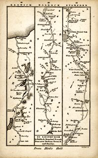 click to enlarge click to enlargeSM22M4.jpg Through Ambleside, Westmorland; then Keswick, Cockermouth to Maryport, Cumberland; and other routes. Included in Smith's Pocket New Companion to the Roads of England and Wales. printed at p.86:- "TO KENDAL / by Halifax & Settle / continued to Keswick &c." item:- private collection : 269.4 Image © see bottom of page |
|||||||||||||||||||||||||||||||||||||||||||||||||||||||||||||||||||||||||||||||||||||||||||||||||||||||||||||||||||||||||||||||||||||||||||||||||||||||||||||||||||||||||||||||||||||||||||||||||||||||||||||||||||||||||||||||||||||||||||||||||||||||||||||||||||
|
|
||||||||||||||||||||||||||||||||||||||||||||||||||||||||||||||||||||||||||||||||||||||||||||||||||||||||||||||||||||||||||||||||||||||||||||||||||||||||||||||||||||||||||||||||||||||||||||||||||||||||||||||||||||||||||||||||||||||||||||||||||||||||||||||||||||
| evidence:- | old itinerary:- Tinsley 1877 (Roads/Cum) |
|||||||||||||||||||||||||||||||||||||||||||||||||||||||||||||||||||||||||||||||||||||||||||||||||||||||||||||||||||||||||||||||||||||||||||||||||||||||||||||||||||||||||||||||||||||||||||||||||||||||||||||||||||||||||||||||||||||||||||||||||||||||||||||||||||
| source data:- | Itinerary, route 7, London to Whitehaven via the Lake Districts, including from Settle,
Lancashire; through Kirkby Lonsdale, Kendal, Ambleside, Westmorland; then Keswick,
Cockermouth to Whitehaven, Cumberland, published by Tinsley Bros, 8 Catherine Street,
Strand, London, 1877.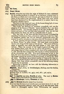 click to enlarge click to enlargeTLY185.jpg pp.71-91 in British High Roads, North and North Eastern Routes; pp.84-91. printed at p.71:- "... / ROUTE VII. - LONDON to WHTEHAVEN via THE LAKE / DISTRICTS. (See Maps 65 to 80.) / Hitchin (as per Route I.) 34, Shefford 41, Bedford 50, Higham-Ferrers, / 64¾, Kettering 74½, Rockingham 83¼, Uppingham 88¾, Oakham, / 94¾, Melton Mowbray 104¾, Nottingham 123¼, Rotherham 159¼, / Barnsley 171¾, Huddersfield 188¾, Halifax 196¾, Keighley 208¾, / Skipton 218¾, Settle 234¾, Kirkby Lonsdale 252½, Kendal 264½, / Ambleside 278½, Keswick 293½, Cockermouth 305½, Whitehaven / 319½. / ..." 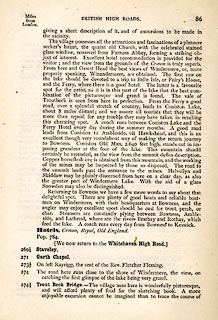 click to enlarge click to enlargeTLY186.jpg 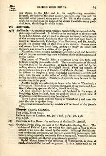 click to enlarge click to enlargeTLY187.jpg 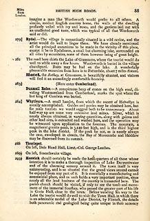 click to enlarge click to enlargeTLY188.jpg 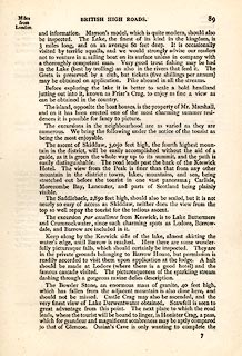 click to enlarge click to enlargeTLY189.jpg 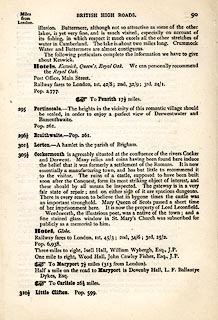 click to enlarge click to enlargeTLY190.jpg item:- private collection : 270.2 Image © see bottom of page |
|||||||||||||||||||||||||||||||||||||||||||||||||||||||||||||||||||||||||||||||||||||||||||||||||||||||||||||||||||||||||||||||||||||||||||||||||||||||||||||||||||||||||||||||||||||||||||||||||||||||||||||||||||||||||||||||||||||||||||||||||||||||||||||||||||
|
|
||||||||||||||||||||||||||||||||||||||||||||||||||||||||||||||||||||||||||||||||||||||||||||||||||||||||||||||||||||||||||||||||||||||||||||||||||||||||||||||||||||||||||||||||||||||||||||||||||||||||||||||||||||||||||||||||||||||||||||||||||||||||||||||||||||
| evidence:- | old strip map:- Tinsley 1877 (Roads/Cum) |
|||||||||||||||||||||||||||||||||||||||||||||||||||||||||||||||||||||||||||||||||||||||||||||||||||||||||||||||||||||||||||||||||||||||||||||||||||||||||||||||||||||||||||||||||||||||||||||||||||||||||||||||||||||||||||||||||||||||||||||||||||||||||||||||||||
| source data:- | Strip map, road map, part of London to Whitehaven, including from before Kirkby Lonsdale
through Kendal, Windermere to beyond Ambleside, Westmorland, published by Tinsley
Bros, 8 Catherine Street, Strand, London, 1877.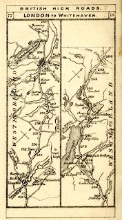 click to enlarge click to enlargeTLY1M4.jpg Map pp.77-78 in British High Roads, North and North Eastern Routes. printed at top:- "BRITISH HIGH ROADS / 77 LONDON TO WHITEHAVEN. 78" item:- private collection : 270.6 Image © see bottom of page |
|||||||||||||||||||||||||||||||||||||||||||||||||||||||||||||||||||||||||||||||||||||||||||||||||||||||||||||||||||||||||||||||||||||||||||||||||||||||||||||||||||||||||||||||||||||||||||||||||||||||||||||||||||||||||||||||||||||||||||||||||||||||||||||||||||
|
|
||||||||||||||||||||||||||||||||||||||||||||||||||||||||||||||||||||||||||||||||||||||||||||||||||||||||||||||||||||||||||||||||||||||||||||||||||||||||||||||||||||||||||||||||||||||||||||||||||||||||||||||||||||||||||||||||||||||||||||||||||||||||||||||||||||
| evidence:- | old strip map:- Tinsley 1877 (Roads/Cum) |
|||||||||||||||||||||||||||||||||||||||||||||||||||||||||||||||||||||||||||||||||||||||||||||||||||||||||||||||||||||||||||||||||||||||||||||||||||||||||||||||||||||||||||||||||||||||||||||||||||||||||||||||||||||||||||||||||||||||||||||||||||||||||||||||||||
| source data:- | Strip map, road map, part of London to Whitehaven, including from before Keswick through
Cockermouth to Whitehaven, Cumberland, published by Tinsley Bros, 8 Catherine Street,
Strand, London, 1877.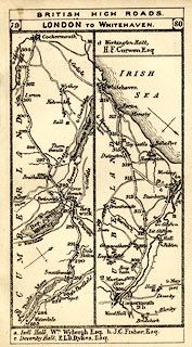 click to enlarge click to enlargeTLY1M5.jpg Map pp.79-80 in British High Roads, North and North Eastern Routes. printed at top:- "BRITISH HIGH ROADS / 79 LONDON TO WHITEHAVEN. 80" item:- private collection : 270.7 Image © see bottom of page |
|||||||||||||||||||||||||||||||||||||||||||||||||||||||||||||||||||||||||||||||||||||||||||||||||||||||||||||||||||||||||||||||||||||||||||||||||||||||||||||||||||||||||||||||||||||||||||||||||||||||||||||||||||||||||||||||||||||||||||||||||||||||||||||||||||
|
|
||||||||||||||||||||||||||||||||||||||||||||||||||||||||||||||||||||||||||||||||||||||||||||||||||||||||||||||||||||||||||||||||||||||||||||||||||||||||||||||||||||||||||||||||||||||||||||||||||||||||||||||||||||||||||||||||||||||||||||||||||||||||||||||||||||
| evidence:- | old itinerary:- Johnson 1908 (Roads/Cum) |
|||||||||||||||||||||||||||||||||||||||||||||||||||||||||||||||||||||||||||||||||||||||||||||||||||||||||||||||||||||||||||||||||||||||||||||||||||||||||||||||||||||||||||||||||||||||||||||||||||||||||||||||||||||||||||||||||||||||||||||||||||||||||||||||||||
| source data:- | Itinerary, Route 42 in Roads Made Easy by Picture and Pen, Kendal to Carlisle, through
The Lakes, by Claude Johnson, edited by Lord Montagu, published by The Car Illustrated,
168 Piccadilly, London, 1908.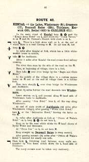 click to enlarge click to enlargeJS5085.jpg pp.85-88 in the road book, Roads Made Easy by Picture and Pen, vol.3. printed at beginning, p.85:- "ROUTE 42. / KENDAL via the Lakes, Windermere (8¼), Grasmere (17), Dunmail Raise (20¼), Thirlmere, Keswick (30), Bothel (42¾), to CARLISLE (61¼)." 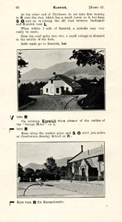 click to enlarge click to enlargeJS5086.jpg 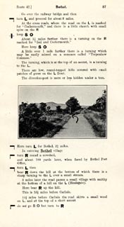 click to enlarge click to enlargeJS5087.jpg item:- private collection : 268.12 Image © see bottom of page |
|||||||||||||||||||||||||||||||||||||||||||||||||||||||||||||||||||||||||||||||||||||||||||||||||||||||||||||||||||||||||||||||||||||||||||||||||||||||||||||||||||||||||||||||||||||||||||||||||||||||||||||||||||||||||||||||||||||||||||||||||||||||||||||||||||
|
|
||||||||||||||||||||||||||||||||||||||||||||||||||||||||||||||||||||||||||||||||||||||||||||||||||||||||||||||||||||||||||||||||||||||||||||||||||||||||||||||||||||||||||||||||||||||||||||||||||||||||||||||||||||||||||||||||||||||||||||||||||||||||||||||||||||
| evidence:- | old itinerary:- Johnson 1908 (Roads/Cum) |
|||||||||||||||||||||||||||||||||||||||||||||||||||||||||||||||||||||||||||||||||||||||||||||||||||||||||||||||||||||||||||||||||||||||||||||||||||||||||||||||||||||||||||||||||||||||||||||||||||||||||||||||||||||||||||||||||||||||||||||||||||||||||||||||||||
| source data:- | Itinerary, Route 42 reverse in Roads Made Easy by Picture and Pen, Carlisle to Kendal,
through The Lakes, by Claude Johnson, edited by Lord Montagu, published by The Car
Illustrated, 168 Piccadilly, London, 1908.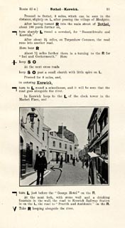 click to enlarge click to enlargeJS5091.jpg pp.89-92 in the road book, Roads Made Easy by Picture and Pen, vol.3. printed at beginning, p.89:- "ROUTE 42. Reverse. / CARLISLE through the Lakes via Bothel (18½), Keswick (31¼), Thirlmere, Dunmail Raise (41), Grasmere (44¼), Windermere (53) to KENDAL (61¼)." 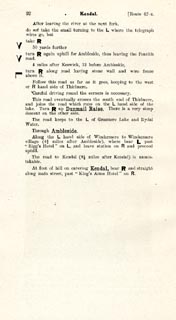 click to enlarge click to enlargeJS5092.jpg item:- private collection : 268.13 Image © see bottom of page |
|||||||||||||||||||||||||||||||||||||||||||||||||||||||||||||||||||||||||||||||||||||||||||||||||||||||||||||||||||||||||||||||||||||||||||||||||||||||||||||||||||||||||||||||||||||||||||||||||||||||||||||||||||||||||||||||||||||||||||||||||||||||||||||||||||
|
|
||||||||||||||||||||||||||||||||||||||||||||||||||||||||||||||||||||||||||||||||||||||||||||||||||||||||||||||||||||||||||||||||||||||||||||||||||||||||||||||||||||||||||||||||||||||||||||||||||||||||||||||||||||||||||||||||||||||||||||||||||||||||||||||||||||
| evidence:- | old strip map:- Geographia 1925 |
|||||||||||||||||||||||||||||||||||||||||||||||||||||||||||||||||||||||||||||||||||||||||||||||||||||||||||||||||||||||||||||||||||||||||||||||||||||||||||||||||||||||||||||||||||||||||||||||||||||||||||||||||||||||||||||||||||||||||||||||||||||||||||||||||||
| source data:- | Road book, with road strip maps and gradient diagrams, Premier Road Book of Great
Britain, by Alexander Gross and F Waite-Browne, published by Geographia, 55 Fleet
Street, London, about 1925?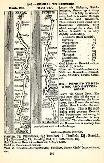 click to enlarge click to enlargeGE1101.jpg "246. - KENDAL TO KESWICK." item:- Hampshire Museums : B1990.161.4 Image © see bottom of page |
|||||||||||||||||||||||||||||||||||||||||||||||||||||||||||||||||||||||||||||||||||||||||||||||||||||||||||||||||||||||||||||||||||||||||||||||||||||||||||||||||||||||||||||||||||||||||||||||||||||||||||||||||||||||||||||||||||||||||||||||||||||||||||||||||||
|
|
||||||||||||||||||||||||||||||||||||||||||||||||||||||||||||||||||||||||||||||||||||||||||||||||||||||||||||||||||||||||||||||||||||||||||||||||||||||||||||||||||||||||||||||||||||||||||||||||||||||||||||||||||||||||||||||||||||||||||||||||||||||||||||||||||||
Lakes Guides menu.