 Old Cumbria Gazetteer
 |
 |
|
| Loughrigg Fell, Lakes | ||
| Loughrigg Fell | ||
| locality:- | Loughrigg | |
| civil parish:- | Lakes (formerly Westmorland) | |
| county:- | Cumbria | |
| locality type:- | hill | |
| locality type:- | fell | |
| coordinates:- | NY35800410 (etc) | |
| 1Km square:- | NY3504 | |
| 10Km square:- | NY30 | |
|
|
||
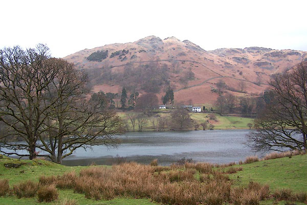 BLV35.jpg (taken 13.4.2006) 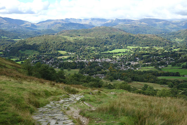 CDZ74.jpg From Wansfell. (taken 22.9.2015) |
||
|
|
||
| evidence:- | old map:- OS County Series (Wmd 26 5) placename:- Loughrigg Fell |
|
| source data:- | Maps, County Series maps of Great Britain, scales 6 and 25
inches to 1 mile, published by the Ordnance Survey, Southampton,
Hampshire, from about 1863 to 1948. |
|
|
|
||
| evidence:- | old map:- Ogilby 1675 (plate 96) |
|
| source data:- | Road strip map, hand coloured engraving, the Road from Kendal to
Cockermouth, and the Road from Egremond to Carlisle, scale about
1 inch to 1 mile, by John Ogilby, London, 1675. OG96m010.jpg In mile 14, Westmerland. Mountains on the left and right of the road. item:- JandMN : 22 Image © see bottom of page |
|
|
|
||
| evidence:- | old map:- Jefferys 1770 (Wmd) placename:- Loughrigg Fell |
|
| source data:- | Map, 4 sheets, The County of Westmoreland, scale 1 inch to 1
mile, surveyed 1768, and engraved and published by Thomas
Jefferys, London, 1770. J5NY30NE.jpg "LOUGHRIGG FELL" hill hachuring; hill or mountain item:- National Library of Scotland : EME.s.47 Image © National Library of Scotland |
|
|
|
||
| evidence:- | old map:- Cary 1789 (edn 1805) placename:- Loughrigg Fell |
|
| source data:- | Map, uncoloured engraving, Westmoreland, scale about 2.5 miles
to 1 inch, by John Cary, London, 1789; edition 1805.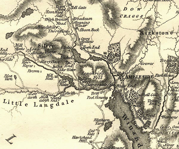 CY24NY30.jpg "Loughrigg Fell" hill hachuring item:- JandMN : 129 Image © see bottom of page |
|
|
|
||
| evidence:- | old map:- Otley 1818 placename:- Loughrigg |
|
| source data:- | Map, uncoloured engraving, The District of the Lakes,
Cumberland, Westmorland, and Lancashire, scale about 4 miles to
1 inch, by Jonathan Otley, 1818, engraved by J and G Menzies,
Edinburgh, Scotland, published by Jonathan Otley, Keswick,
Cumberland, et al, 1833.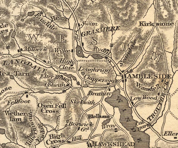 OT02NY30.jpg item:- JandMN : 48.1 Image © see bottom of page |
|
|
|
||
| evidence:- | outline view:- Otley 1823 (8th edn 1849) placename:- Loughrigg Fell |
|
| source data:- | Engraving, outline view of mountains, Windermere looking towards the North East from
Bowness, drawn by T Binns, engraved by O Jewitt, opposite p.2 of A Descriptive Guide
of the English Lakes, by Jonathan Otley, 8th edition, 1849.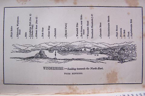 click to enlarge click to enlargeO80E02.jpg With a list of mountains. item:- Armitt Library : A1180.3 Image © see bottom of page |
|
|
|
||
| evidence:- | outline view:- Otley 1823 (8th edn 1849) placename:- Loughrigg Fell |
|
| source data:- | Engraving, outline view of mountains, Grasmere from Red Bank Head, drawn by T Binns,
engraved by O Jewitt, opposite p.4 of A Descriptive Guide of the English Lakes, by
Jonathan Otley, 8th edition, 1849.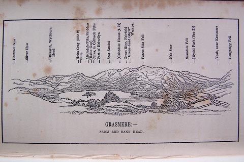 click to enlarge click to enlargeO80E04.jpg item:- Armitt Library : A1180.5 Image © see bottom of page |
|
|
|
||
| evidence:- | outline view:- Otley 1823 (5th edn 1834) |
|
| source data:- | Print, woodcut outline view, The Mountains of Grasmere and
Rydal, by Jonathan Otley, Keswick, Cumberland, 1830.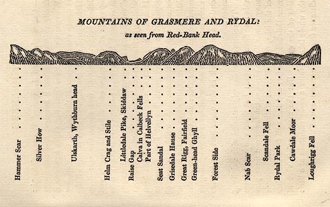 click to enlarge click to enlargeOT2E03.jpg Printed on p.15 of A Concise Description of the English Lakes, by Jonathan Otley, 5th edition, 1834. "MOUNTAINS OF GRASMERE AND RYDAL: as seen from Red-Bank Head." "Hammer Scar / Silver How / Ullskarth, Wythburn head / Helm Crag and Stile / Littledale Pike, Skiddaw / Raise Gap / Calva in Caldbeck Fells / Part of Helvellyn / Seat Sandal / Grisedale Hause / Great Rigg, Fairfield / Green-head Ghyll / Forest Side / Nab Scar / Scandale Fell / Rydal Park / Cawdale Moor / Loughrigg Fell" item:- JandMN : 48.4 Image © see bottom of page |
|
|
|
||
| evidence:- | outline view:- Otley 1823 (5th edn 1834) |
|
| source data:- | Print, woodcut outline view, Mountains North East of Windermere, by Jonathan Otley,
Keswick, Cumberland, 1830.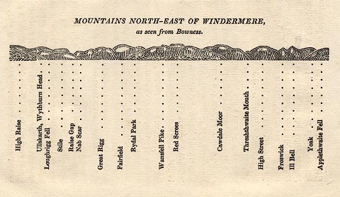 click to enlarge click to enlargeOT2E11.jpg Printed on p.99 of A Concise Description of the English Lakes, by Jonathan Otley, 5th edition, 1834. "MOUNTAINS NORTH-EAST OF WINDERMERE, as seen from Bowness." Mountains are listed:- "High Raise / Ullskarth, Wythburn Head / Loughrigg Fell / Stile / Raise Gap / Nab Scar / Great Rigg / Fairfield / Rydal Park / Wansfell Pike / Red Screes / Cawdale Moor / Threshthwaite Mouth / High Street / Froswick / Ill Bell / Yoak / Applethwaite Fell" item:- JandMN : 48.12 Image © see bottom of page |
|
|
|
||
| evidence:- | descriptive text:- Otley 1823 (5th edn 1834) |
|
| source data:- | Guide book, A Concise Description of the English Lakes, the
mountains in their vicinity, and the roads by which they may be
visited, with remarks on the mineralogy and geology of the
district, by Jonathan Otley, published by the author, Keswick,
Cumberland now Cumbria, by J Richardson, London, and by Arthur
Foster, Kirkby Lonsdale, Cumbria, 1823; published 1823-49,
latterly as the Descriptive Guide to the English Lakes. goto source goto sourcePage 76:- "LOUGHRIGG FELL," "The last, and lowest, but not the least worthy of notice - is scarcely 1000 feet above Windermere, and 900 feet above Grasmere Lake; and the moderate degree of exertion required to climb it, will be amply repaid by the prospects. It is just what might be wished in the place where it stands - high" goto sourcePage 77:- "enough to command a view of the circumjacent vallies; and not so lofty as to lessen the importance of the surrounding mountains. ..." |
|
|
|
||
| evidence:- | old print:- Westall 1830s placename:- Loughrigg Fell |
|
| source data:- | Print, aquatint panorama, Rydal, from Mr Wordsworth's Field under Rydal Mount, Westmorland,
drawn and engraved by William Westall, published by R Ackermann, 96 Strand, London,
1830s.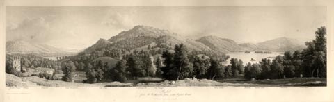 click to enlarge click to enlargeWTL309.jpg "Rydal Chapel & Village. Wansfell. Lake Windermere. Gate Crag. Loughrigg fell. Ivy Cottage. River Rotha. Bowfell. Rydal Lake. Silverhow. White moss. / Drawn & Engraved by W. Westall A.R.A. / Rydal, from Mr Wordsworth's field under Rydal Mount. / Published by R. Ackermann, 96 Strand." item:- Armitt Library : A6658.9 Image © see bottom of page |
|
|
|
||
| evidence:- | descriptive text:- Ford 1839 (3rd edn 1843) placename:- Loughrigg Fell |
|
| source data:- | Guide book, A Description of Scenery in the Lake District, by
Rev William Ford, published by Charles Thurnam, Carlisle, by W
Edwards, 12 Ave Maria Lane, Charles Tilt, Fleet Street, William
Smith, 113 Fleet Street, London, by Currie and Bowman,
Newcastle, by Bancks and Co, Manchester, by Oliver and Boyd,
Edinburgh, and by Sinclair, Dumfries, 1839. goto source Page 35:- "..." "LOUGHRIGG FELL AND TARN." "No fell unfolds scenes so unequalled from such a moderate elevation, with so little fatigue, as Loughrigg, lying to the west of Ambleside. Leaving the Market-place, the pedestrian proceeds to Miller Bridge, from whence there is a fine retrospective view of the town, thence to Ivy Crag, and so to the top, which is one thousand and fifty feet above Windermere. A considerable part of the Queen of Lakes, as well as Rydal and Grasmere, may be seen by traversing its different points, together with portions of Coniston and Thirlmere, and the Tarns of Blelham and Elter Water. Loughrigg Tarn lies under the west end of the Fell, ... above which rise rocky and barren steeps, intermingled with wood; and the solemn" goto sourcePage 36:- "Pikes of Langdale overlook the low, cultivated ridge of land, that forms the northern boundary of this small, quiet, and fertile spot." |
|
|
|
||
| evidence:- | old map:- Garnett 1850s-60s H placename:- Loughrigg Fell |
|
| source data:- | Map of the English Lakes, in Cumberland, Westmorland and
Lancashire, scale about 3.5 miles to 1 inch, published by John
Garnett, Windermere, Westmorland, 1850s-60s. GAR2NY30.jpg "Loughrigg Fell" hill hachuring item:- JandMN : 82.1 Image © see bottom of page |
|
|
|
||
| evidence:- | outline view:- Martineau 1855 |
|
| source data:- | Print, engraving, outline view, Mountains on the West Side of Windermere, drawn by
L Aspland, engraved by W Banks, Edinburgh, published by John Garnett, Windermere,
Westmorland, and by Whittaker and Co, London, 1855.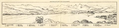 click to enlarge click to enlargeMNU102.jpg Folded in opposite p.7 in A Complete Guide to the English Lakes, by Harriet Martineau. "MOUNTAINS ON THE WEST SIDE OF WINDERMERE" "L Aspland Delt. / W Banks Sc Edinburgh." The view is captioned, numbers referring to mountains in the image:- "1 Coniston Old Man 1a Carrs 2 Wetherlam 3 Wrynose Gap 4 Crinkle Crags 5 Pike of Bliscow 6 Scawfell Pike 7 Bowfell 8 Hanging Knotts 9 Glaramara 10 Great End 11 Pike of Stickle 12 Harrison Stickle 13 Paveyark 14 Lingmoor 15 High Raise 16 Silver How 17 Loughrigg Fell 18 Ullscarth" item:- Armitt Library : A1159.2 Image © see bottom of page |
|
|
|
||
| evidence:- | old text:- Martineau 1855 |
|
| source data:- | Guide book, A Complete Guide to the English Lakes, by Harriet
Martineau, published by John Garnett, Windermere, Westmorland,
and by Whittaker and Co, London, 1855; published 1855-76. goto source Page 19:- "..." "... The valleys of the Rothay and the Brathay are separated by Loughrigg,- the ridge of which, at its further end, commands Grasmere; its Windermere end shelters Clappersgate and Waterhead." "..." goto sourcePage 46:- "... he may now see, above Clappersgate, the path by which he may ascend or descend; a zig-zag path up the hill side, leading to the two peaks, crowning the south end of Loughrigg, from between which the most perfect possible view of Windermere is obtained. ..." "..." goto sourcePage 58:- "... Loughrigg is very easy and very charming; but it is not commanding enough. From the surrounding heights it looks like a mere rambling hill. ..." |
|
|
|
||
| evidence:- | outline view:- Martineau 1855 |
|
| source data:- | Print, engraving, outline view, Mountains seen a little beyond Rydal Mount, drawn
by L Aspland, engraved by W Banks, Edinburgh, published by John Garnett, Windermere,
Westmorland, and by Whittaker and Co, London, 1855.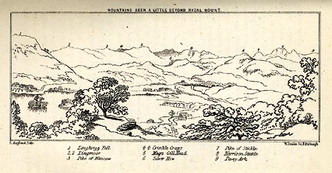 click to enlarge click to enlargeMNU109.jpg Opposite p.64 in A Complete Guide to the English Lakes, by Harriet Martineau. "MOUNTAINS SEEN A LITTLE BEYOND RYDAL MOUNT." "L Aspland Delt. / W Banks Sc Edinr." The view is captioned, numbers referring to mountains in the image:- "1 Loughrigg Fell, 2 Lingmoor, 3 Pike of Bliscow, 4 Crinkle Crags, 5 Meg's Gill Head, 6 Silver How, 7 Pike of Stickle, 8 Harrison Stickle, 9 Pavey Ark" item:- Armitt Library : A1159.9 Image © see bottom of page |
|
|
|
||
| evidence:- | old photograph:- Bell 1880s-1940s |
|
| source data:- | Photograph, sepia, Rydal Water and Loughrigg Fell, Rydal, Westmorland, by Herbert
Bell, photographer, Ambleside, Westmorland, 1890s.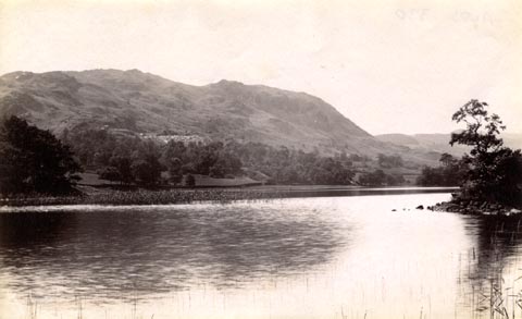 click to enlarge click to enlargeHB0667.jpg item:- Armitt Library : ALPS330 Image © see bottom of page |
|
|
|
||
| evidence:- | old drawing:- Brockbank 1870s placename:- Loughrigg Fell |
|
| source data:- | Drawing, pencil and ink wash, glacial erratic, Loughrigg Fell, Westmorland, 27 May
1872, used by William Brockbank.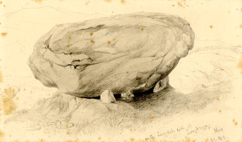 click to enlarge click to enlargePR1924.jpg "on the Langdale side of / Loughrigg. / May / 27. 1972." "Perched Block on Loughrigg. / Langdale. / Wm. Brock[ban ] / 19" item:- Armitt Library : 1959.68.19 Image © see bottom of page |
|
|
|
||
| evidence:- | outline view:- Black 1856 (23rd edn 1900) placename:- Loughrigg Fell |
|
| source data:- | Print, lithograph, Outline Views, Windermere - Mountains as seen from the North End
of Belle Isle, Windermere, and Mountains as seen from Biscay How, Bowness, by J Flintoft,
Keswick, Cumberland, engraved by R Mason, Edinburgh, Lothian, about 1900.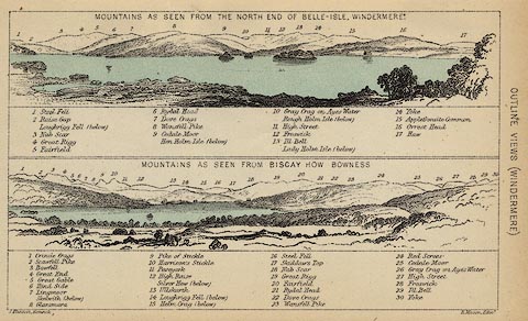 click to enlarge click to enlargeBC08E1.jpg "... Loughrigg Fell ... 14 Loughrigg Fell ..." item:- JandMN : 37.4 Image © see bottom of page |
|
|
|
||
| evidence:- | old print:- Pyne 1853 placename:- Loughrigg Fell |
|
| source data:- | Grasmere from Loughrigg Fell drawn by James Barker Pyne, 1848-1853, lithographed by
T Picken, 1859.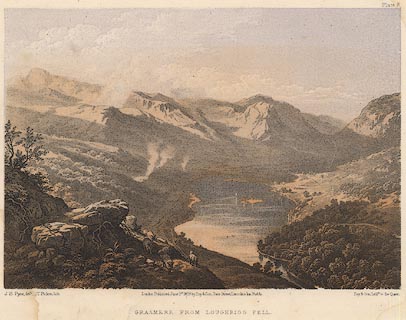 click to enlarge click to enlargePY08.jpg "Grasmere from Loughrigg Fell" item:- JandMN : 97.9 Image © see bottom of page |
|
|
|
||
| evidence:- | outline view:- Black 1841 (3rd edn 1846) placename:- Loughrigg Fell |
|
| source data:- | Print, engraving, outline view, Mountains as seen from the North End of Belle Isle,
Windermere, and Mountains as seen from Bisket How, Bowness, by J Flintoft, Keswick,
Cumberland, engraved by R Mason, Edinburgh, about 1844.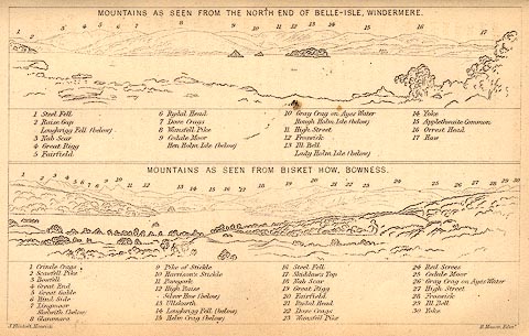 click to enlarge click to enlargeBC02E1.jpg "... Loughrigg Fell ... 14 Loughrigg Fell ..." item:- JandMN : 32.3 Image © see bottom of page |
|
|
|
||
| evidence:- | outline view:- Tattersall 1836 (version 1869) placename:- Loughrigg Fell |
|
| source data:- | Print, hand coloured, Rydal Water, from the South East, Westmorland, drawn by George
Tattersall, 1836, engraved by W F Topham, published by T J Allman, 463 Oxford Street,
London, 1869.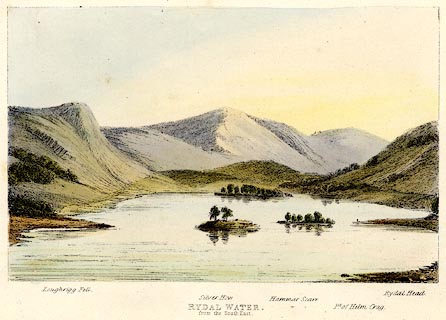 click to enlarge click to enlargeTAT206.jpg Included in The Lakes of England, by W F Topham. printed at bottom:- "RYDAL WATER, / from the South East." printed at bottom:- "Loughrigg Fell. / Silver How. / Hammar Scarr. / Pt. of Helm Crag. / Rydal Head." item:- Armitt Library : A1067.6 Image © see bottom of page |
|
|
|
||
| evidence:- | outline view:- Tattersall 1836 placename:- Loughrigg Fell |
|
| source data:- | Print, engraving, Rydal Water, from the South East, Westmorland, drawn by George Tattersall,
engraved by W F Topham, published by Sherwood and Co, Paternoster Row, London, about
1836.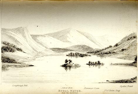 click to enlarge click to enlargeTAT111.jpg The print is captioned with mountain names and acts as an outline view. Tipped in opposite p.44 of The Lakes of England, by George Tattersall. printed at bottom:- "RYDAL WATER, / from the South East." printed at bottom left to right:- "Loughrigg Fell. / Silver How. / Hammar Scarr. / Pt. of Helm Crag. / Rydal Head." item:- Armitt Library : A1204.12 Image © see bottom of page |
|
|
|
||
| evidence:- | outline view:- Tattersall 1836 placename:- Loughrigg Fell |
|
| source data:- | Print, engraving, Windermere from Rayrigg Bank, Westmorland, drawn by George Tattersall,
engraved by W F Topham, published by Sherwood and Co, Paternoster Row, London, about
1836.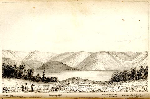 click to enlarge click to enlargeTAT104.jpg The print is captioned with mountain names and acts as an outline view. Tipped in opposite p.31 of The Lakes of England, by George Tattersall. printed at bottom:- "WINDERMERE from RAYRIGG BANK." printed at bottom left to right:- "Furness Fells. / Coniston Old Man. / Wetherlam Foot. / Wrynose. / Langdale Pikes. / Hardknot. / Loughrigg Fell. / Fairfield. / Troutbeck Hundred. / Kirkstone. / Wansfell. / Applethwaite Common. / High Street. / Hill Bell." item:- Armitt Library : A1204.5 Image © see bottom of page |
|
|
|
||
| evidence:- | outline view:- Tattersall 1836 placename:- Loughrigg Fell item:- boat; rowing boat |
|
| source data:- | Print, engraving, Upper Reach, Windermere, Westmorland, drawn by George Tattersall,
engraved by W F Topham, published by Sherwood and Co, Paternoster Row, London, about
1836.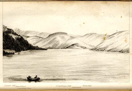 click to enlarge click to enlargeTAT102.jpg The print is captioned with mountain names and acts as an outline view. Tipped in opposite p.25 of The Lakes of England, by George Tattersall. printed at bottom:- "UPPER REACH, WINDERMERE." printed at bottom left to right:- "Furness Fell. / Hard Knot. / Langdale Pikes. / Loughrigg Fell. / Fairfield. / Wansfell." item:- Armitt Library : A1204.3 Image © see bottom of page |
|
|
|
||
| evidence:- | old print:- Green 1809 placename:- Loughrigg Fell |
|
| source data:- | Print, soft ground etching, Grasmere, Westmorland, by William Green, published by
William Green, Ambleside, Westmorland, and Longman, Hurst, Rees and Orme, Paternoster
Row, London, 1809.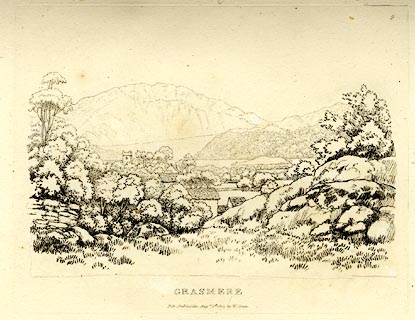 click to enlarge click to enlargeGN0309.jpg Plate 9 in Seventy Eight Studies from Nature. printed in introductory pages to set of prints:- "Number 9. Loughrigg Fell is the distant object in this little scene, which is viewed from a place called the How: This is one of the many beautiful eminences in which Grasmere so much abounds." printed at bottom:- "GRASMERE. / Pub. Ambleside, Augst. 1st. 1809, by W. Green." item:- Armitt Library : A6637.9 Image © see bottom of page |
|
|
|
||
| evidence:- | old print:- Green 1809 placename:- Loughrigg Fell |
|
| source data:- | Print, soft ground etching, Stones on Loughrigg Fell, Westmorland, by William Green,
published by William Green, Ambleside, Westmorland, and Longman, Hurst, Rees and Orme,
Paternoster Row, London, 1809.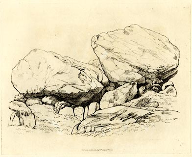 click to enlarge click to enlargeGN0332.jpg Plate 32 in Seventy Eight Studies from Nature. printed in introductory pages to set of prints:- "Number 32. Stones on Loughrigg Fell." printed at bottom:- "Published Ambleside, Augst. 1st. 1809, by W. Green." item:- Armitt Library : A6637.32 Image © see bottom of page |
|
|
|
||
| evidence:- | old print:- Green 1809 placename:- Loughrigg Fell |
|
| source data:- | Print, soft ground etching, Stone on Loughrigg Fell, Westmorland, by William Green,
published by William Green, Ambleside, Westmorland, and Longman, Hurst, Rees and Orme,
Paternoster Row, London, 1809.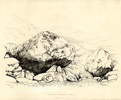 click to enlarge click to enlargeGN0359.jpg Plate 59 in Seventy Eight Studies from Nature. printed in introductory pages to set of prints:- "Number 59, and 60. Loughrigg Fell is the western boundary of the vallies of Ambleside and Rydal. There is no hill of a moderate height in the neighbourhood of Ambleside, that furnishes such a variety of singular scenes as Loughrigg Fell. A fine ascent to it is from Clappersgate, leaving the pubic road at No.7, in this work. ..." printed at bottom:- "STONE ON LOUGHRIGG FELL. / Published Ambleside, Augst. 1st. 1809, by W. Green." item:- Armitt Library : A6637.59 Image © see bottom of page |
|
|
|
||
| evidence:- | old print:- Green 1809 placename:- Loughrigg Fell |
|
| source data:- | Print, soft ground etching, Stones on Loughrigg Fell, Westmorland, by William Green,
published by William Green, Ambleside, Westmorland, and Longman, Hurst, Rees and Orme,
Paternoster Row, London, 1809.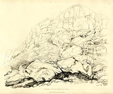 click to enlarge click to enlargeGN0360.jpg Plate 60 in Seventy Eight Studies from Nature. printed at bottom:- "STONES ON LOUGHRIGG FELL. / Published Ambleside, Augst. 1st. 1809, by W. Green." item:- Armitt Library : A6637.60 Image © see bottom of page |
|
|
|
||
Lakes Guides menu.