 Old Cumbria Gazetteer
 |
 |
|
| Lord's Island, Derwent Water | ||
| Lord's Island | ||
| Crow Island | ||
| site name:- | Derwent Water | |
| civil parish:- | Borrowdale (formerly Cumberland) | |
| county:- | Cumbria | |
| locality type:- | island | |
| coordinates:- | NY26542189 | |
| 1Km square:- | NY2621 | |
| 10Km square:- | NY22 | |
|
|
||
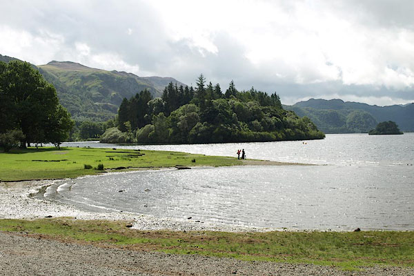 BPQ01.jpg (taken 24.8.2008) 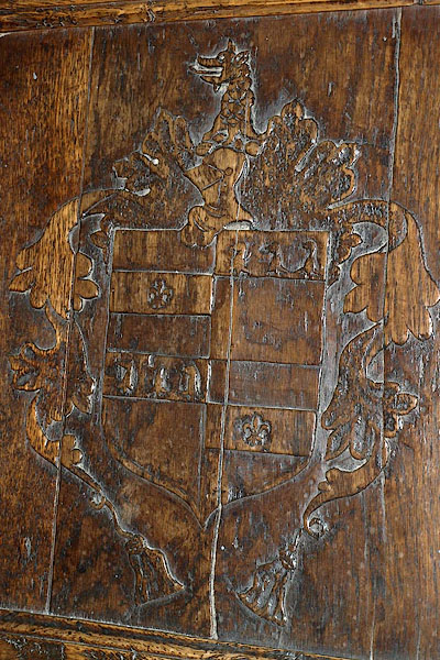 BRA65.jpg Coat of arms on Lord Derwentwater's Chair; ?wrongly said to have belonged to Sir John Radcliffe, Lord's Island, died 1529. The arms are NOT the Radcliffe Family arms. (taken 24.8.2008) courtesy of Keswick Museum |
||
|
|
||
| evidence:- | old map:- OS County Series (Cmd 64 10) placename:- Lords Island |
|
| source data:- | Maps, County Series maps of Great Britain, scales 6 and 25
inches to 1 mile, published by the Ordnance Survey, Southampton,
Hampshire, from about 1863 to 1948. |
|
|
|
||
| evidence:- | descriptive text:- Simpson 1746 |
|
| source data:- | Atlas, three volumes of maps and descriptive text published as
'The Agreeable Historian, or the Compleat English Traveller
...', by Samuel Simpson, 1746. goto source goto source"..." "... in which [Derwent Water] there are three Islands, ... and the third has of late Years, had the Honour to be the Seat of the famous Family of Radcliffs, Knights, called from hence, for Distinction Sake, the Radcliffs of Derwentwater; the last of which Family was the late unhappy James, Earl of Derwentwater, who joining in a Rebellion against his Majesty King George I. was taken at the Battle of Preston in Lancashire, and beheaded on Tower Hill the 24th of February, 1716." |
|
|
|
||
| evidence:- | old text:- Gents Mag placename:- Lady Island |
|
| source data:- | Magazine, The Gentleman's Magazine or Monthly Intelligencer or
Historical Chronicle, published by Edward Cave under the
pseudonym Sylvanus Urban, and by other publishers, London,
monthly from 1731 to 1922. goto source Gentleman's Magazine 1751 p.52 "... one of these, called Lady Island, Ld Derwentwater had formerly a castle, now in ruins, intended to prevent the depredations which were frequently committed by the Scots before the union." |
|
|
|
||
| evidence:- | old map:- Gents Mag 1751 placename:- Lady Island |
|
| source data:- | Map, uncoloured engraving, Map of the Black Lead Mines in
Cumberland, and area, scale about 2 miles to 1 inch, by George
Smith, published in the Gentleman's Magazine, 1751.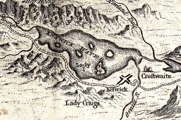 GM1311.jpg "Lady I" island item:- JandMN : 114 Image © see bottom of page |
|
|
|
||
| evidence:- | old map:- Bowen and Kitchin 1760 |
|
| source data:- | Map, hand coloured engraving, A New Map of the Counties of
Cumberland and Westmoreland Divided into their Respective Wards,
scale about 4 miles to 1 inch, by Emanuel Bowen and Thomas
Kitchin et al, published by T Bowles, Robert Sayer, and John
Bowles, London, 1760.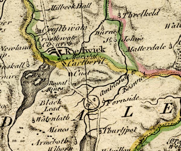 BO18NY21.jpg in Derwent Water; the Royal Mines label belongs with the northerly island. item:- Armitt Library : 2008.14.10 Image © see bottom of page |
|
|
|
||
| evidence:- | old map:- Donald 1774 (Cmd) |
|
| source data:- | Map, hand coloured engraving, 3x2 sheets, The County of Cumberland, scale about 1
inch to 1 mile, by Thomas Donald, engraved and published by Joseph Hodskinson, 29
Arundel Street, Strand, London, 1774.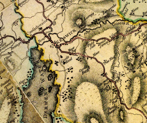 D4NY22SE.jpg island in Derwent Water item:- Carlisle Library : Map 2 Image © Carlisle Library |
|
|
|
||
| evidence:- | descriptive text:- West 1778 (11th edn 1821) placename:- Lords Island |
|
| source data:- | Guide book, A Guide to the Lakes, by Thomas West, published by
William Pennington, Kendal, Cumbria once Westmorland, and in
London, 1778 to 1821. goto source Page 90:- "[Derwent water] ... Lords-island, richly dressed in wood." "..." goto sourcePage 115:- "[Mr Pennant's description] '... The isles that decorate this water are finely disposed, and very distinct, rise with gentle and regular curvatures above the surface, consist of verdant turf, or are planted with various trees. The principal is Lord's-island, above five acres, where the Ratcliff family had some time its residence, and, from this lake, took the title of Derwent-water. ...'" |
|
|
|
||
| evidence:- | old map:- Crosthwaite 1783-94 (Der) placename:- Lord's Island |
|
| source data:- | Map, uncoloured engraving, An Accurate Map of the Matchless Lake
of Derwent, ie Derwent Water, scale about 3 inches to 1 mile, by
Peter Crosthwaite, Keswick, Cumberland, 1783, version published
1800.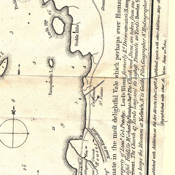 CT2NY21U.jpg "Lord's Isld." In the map title:- "Lord's Island, formerly Ld. Derwentwater's" item:- Armitt Library : 1959.191.3 Image © see bottom of page |
|
|
|
||
| evidence:- | probably old map:- West 1784 map |
|
| source data:- | Map, hand coloured engraving, A Map of the Lakes in Cumberland,
Westmorland and Lancashire, scale about 3.5 miles to 1 inch,
engraved by Paas, 53 Holborn, London, about 1784. Ws02NY22.jpg item:- Armitt Library : A1221.1 Image © see bottom of page |
|
|
|
||
| evidence:- | old sketch map:- Gilpin 1786 placename:- Lords Island |
|
| source data:- | Sketch map, Keswick Lake ie Derwent Water, Cumberland, by William Gilpin, 1772-74 goto source click to enlarge click to enlargeGLP312.jpg Plate vol 1 opposite p.179 in Observations on Picturesque Beauty published by T Cadell and W Davies, Strand, London, 1808. caption from the list of plates:- "This plan of Keswick-lake means only to express the general shape of it; and the relative situation of it's several parts." item:- Armitt Library : A918.12 Image © see bottom of page |
|
|
|
||
| evidence:- | old text:- Gilpin 1786 placename:- Lords Island |
|
| source data:- | Book, Observations, Relative Chiefly to Picturesque Beauty, Made
in the Year 1772, on Several Parts of England, Particularly the
Mountains, and Lakes of Cumberland Westmoreland, by Rev William
Gilpin, 1772-74; published 1786-1808. goto source vol.1 p.180 "The lake of Derwent, or Keswick-lake, as it is generally called, is contained within a circumference of about ten miles; presenting itself in a circular form, tho in fact it is rather oblong. It's area is interspersed with four or five islands; three of which only are of consequence, Lord's island, Vicar's island, and St. Herbert's island: but none of them is comparable to the island on Windermere, in point either of size, or beauty." goto sourcevol.1 p.181 "Lord's island has it's name from being the place, where once stood a pleasure-house, belonging to the unfortunate family of Derwent-water, which took it's title from this lake. The ancient manor-house stood on Castle-hill above Keswick; where the antiquarian traces also the vestiges of a Roman fort. But an heiress of Derwent-water marrying into the family of the Ratcliffs; the family-seat was removed from Keswick to Dilston in Northumberland." goto sourcevol.1 p.184 "..." "To the formality of it's shores may be added the formality of it's islands. They are round, regular, and similar spots, as they appear from most points of view; formal in their situation, as well as in their shape; and of little advantage to the scene. ..." |
|
|
|
||
| evidence:- | old text:- Clarke 1787 placename:- Lord's Island item:- Scots fir; mouse; cat |
|
| source data:- | Guide book, A Survey of the Lakes of Cumberland, Westmorland,
and Lancashire, written and published by James Clarke, Penrith,
Cumberland, and in London etc, 1787; published 1787-93. goto source Page 70:- "..." "Upon Lord's Island, the Radcliffs, Earls of Derwentwater, formerly had a seat, which, according to Nicholson and Burn, was built of stones that came from a castle founded by the Romans upon Castrigg, or Castle-Rigg. I do not believe the story, which I shall endeavour to prove when we pass it. There are some remains of the building upon the island to be seen, but the whole is now covered with wood." "This once-flourishing family lost their estates in the year 1715, which were given by his Majesty King George I. to Greenwich Hospital. There is nothing upon this island worth landing for, except the refreshing shade upon a very hot day. It is planted with Scots firs, about twenty-seven years standing; amongst which there is room to walk, and seldom wants a fine cooling breeze. At the first planting of these trees, the island was so much infested with vermin, particularly mice, that they totally defeated all labours of the planters. So numerous and mischievous were these vermin, that after the trees had been planted three or four years, they were almost entirely destroyed by them: some, (particularly the firs,) were totally gnawed through a little above the ground; and others stripped of their bark, and thereby deprived of nutriment. Upon this, Mr Nicholson, who was Agent and Bailiff for Greenwich Hospital, collected several cats, whom he turned loose upon the island, and who soon overcame the mice. Afterwards some of the cats boldly swam to shore, and run wild amongst the woods; others perished with hunger, and some remained for several years." |
|
|
|
||
| evidence:- | old map:- Clarke 1787 map (Der) placename:- Lord's Island |
|
| source data:- | Map, uncoloured engraving, Map of Derwentwater and its Environs,
scale about 13 ins to 1 mile, by James Clarke, engraved by S J
Neele, published by James Clarke, Penrith, Cumberland and in
London etc, 1787.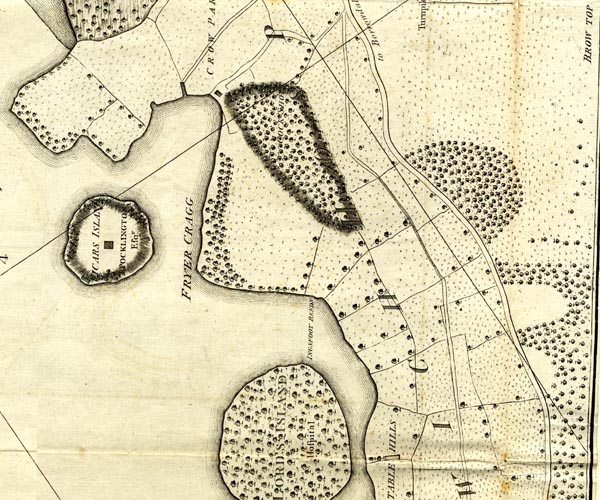 CL152622.jpg "LORD'S ISLAND / Hospital" wooded island item:- private collection : 169 Image © see bottom of page |
|
|
|
||
| evidence:- | old text:- Camden 1789 (Gough Additions) item:- 1715 Rebellion; Greenwich Hospital; oak; tree |
|
| source data:- | Book, Britannia, or A Chorographical Description of the Flourishing Kingdoms of England,
Scotland, and Ireland, by William Camden, 1586, translated from the 1607 Latin edition
by Richard Gough, published London, 1789. goto source Page 181:- "..." "The Derwentwater family took their name from the place where they were seated from the reign of Edward I. Sir Nicholas Radcliffe of Dilston c. Northumberland, knt. married the heiress of the family in the reign of Henry VI. and his descendant Francis was created by James II. baron of Dilston, viscount Langley and Radcliff, and earl of Derwentwater; all which titles were forfeited with his estate and life by his son James, beheaded on Tower-hill 1716 for engaging in the rebellion. The estate amounted to £.20,000. a year, including the mines, was vested in trustees for the support of Greenwich hospital, but restored on the reversal of the attainder 177[ ]." "..." "... Castlerigg was the antient seat of the Derwentwater family, but after the marriage with the Radcliffs went to ruin, and with the materials the Radcliffs built a pleasure-house in one of the islands in Derwentwater. The large and stately oaks were felled by the trustees of Greenwich hospital, who lately replaced them by some small plantations. ..." |
|
|
|
||
| evidence:- | old print:- Green 1810 (plate 31) |
|
| source data:- | Print, soft ground etching, Islands on Derwent Water from Castlerigg, Keswick, Cumberland,
by William Green, Ambleside, Westmorland, 1810.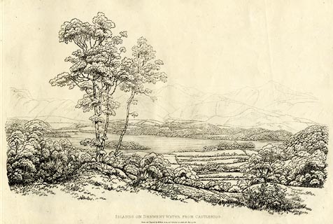 click to enlarge click to enlargeGN1231.jpg From near right to far - Derwent Isle, Lord's Island, St Herbert's Island? Plate 31 in Sixty Studies from Nature, 1810. printed at top right:- "31" printed at bottom:- "ISLANDS ON DERWENT WATER FROM CASTLERIGG. / Drawn and Engraved by William Green, and Published at Ambleside, June 24, 1810." watermark:- "J WHATMAN / 1813" item:- Armitt Library : A6641.31 Image © see bottom of page |
|
|
|
||
| evidence:- | old text:- Farington 1816 placename:- Lord's Island |
|
| source data:- | Descriptive text:- "... Much of the beauty of this Lake [Derwent Water] is derived from the islands, four
or five in number, which are interspersed in it: the principal of these are, Lord's
Island and that of St. Herbert. The former is situated near the north-eastern side
of the Lake, and contains about five acres: it was once possessed by the Ratcliffe
family, who had a residence here and took the title of Derwentwater from the Lake
itself. In consequence of the activity of the last Earl, in the rebellion of 1715,
it became forfeited, together with the other estates of that family in the neighbourhood;
and the whole is now vested in Trustees for the benefit of Greenwich Hospital. ..." item:- Armitt Library : A6666.15 Image © see bottom of page |
|
|
|
||
| evidence:- | descriptive text:- Otley 1823 (5th edn 1834) placename:- Lord's Isle |
|
| source data:- | Guide book, A Concise Description of the English Lakes, the
mountains in their vicinity, and the roads by which they may be
visited, with remarks on the mineralogy and geology of the
district, by Jonathan Otley, published by the author, Keswick,
Cumberland now Cumbria, by J Richardson, London, and by Arthur
Foster, Kirkby Lonsdale, Cumbria, 1823; published 1823-49,
latterly as the Descriptive Guide to the English Lakes. goto source Page 17:- "... Lord's Isle, contains about six acres and a half, and is covered with stately trees, forming a fine rookery. It is situated near the shore, on which account, probably, it was selected for the residence of the family of Derwentwater; but the house has long been in ruins, and nothing now remains but the foundation. This, and the smaller island called Rampsholm, form part of the late Earl of Derwentwater's sequestrated estate, which has been purchased from Greenwich Hospital in 1832, by John Marshall, Esq. of Leeds." "..." goto sourcePage 118:- "... Lord's Island, near the shore, was once the residence of the family [of Derwentwater.]" |
|
|
|
||
| evidence:- | descriptive text:- Ford 1839 (3rd edn 1843) placename:- Lord's Island |
|
| source data:- | Guide book, A Description of Scenery in the Lake District, by
Rev William Ford, published by Charles Thurnam, Carlisle, by W
Edwards, 12 Ave Maria Lane, Charles Tilt, Fleet Street, William
Smith, 113 Fleet Street, London, by Currie and Bowman,
Newcastle, by Bancks and Co, Manchester, by Oliver and Boyd,
Edinburgh, and by Sinclair, Dumfries, 1839. goto source Page 54:- "... Lord's Island, six acres in extent, once the residence of the unfortunate Radcliffes, is now entirely covered with wood: it is, along with Rampsholm, the property of W. Marshall, Esq. who purchased the Greenwich Hospital estates in this district. ..." |
|
|
|
||
| evidence:- | old text:- Martineau 1855 item:- aurora borealis; Lord Derwentwater's lights |
|
| source data:- | Guide book, A Complete Guide to the English Lakes, by Harriet
Martineau, published by John Garnett, Windermere, Westmorland,
and by Whittaker and Co, London, 1855; published 1855-76. goto source Page 74:- "... The Ratcliffes also possessed Lord's Island, the largest on the lake, where their mansion is said to have been built, from the stones of the old one on Castlehead. ..." goto sourcePage 75:- "... Lord's Isle was once a part of the mainland. The Ratcliffes cut a fosse, in the feudal times, and set up a drawbridge. ... ... Every where are there traces of the unhappy family; even in the sky, where the aurora borealis is sometimes called, to this day, Lord Derwentwater's lights, because it was particularly brilliant the night after his execution." |
|
|
|
||
| evidence:- | old print:- Gresham Publishing 1900s |
|
| source data:- | Print, colour halftone, Derwentwater from Friars Crag, Cumberland, by Ernest W Haslehurst,
published by The Gresham Publishing Co, 66 Chandos Street, London, 1900s?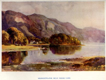 click to enlarge click to enlargePR1567.jpg Tipped in opposite p.40 of The English Lakes section of a volume of Our Beautiful Homeland. printed at bottom:- "DERWENTWATER FROM FRIARS CRAG" printed at lower left:- "E. W. HASLEHURST" item:- JandMN : 381.9 Image © see bottom of page |
|
|
|
||
| evidence:- | outline view:- Black 1856 (23rd edn 1900) placename:- Lord's Isle |
|
| source data:- | Print, lithograph, Outline Views, Skiddaw and Derwent Water - Mountains as seen at
Lodore Hotel, and Mountains as seen at the Third Gate on Ascending Latrigg on the
Way to Skiddaw, by J Flintoft, Keswick, Cumberland, engraved by R Mason, Edinburgh,
Lothian, about 1900.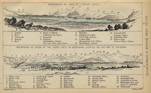 click to enlarge click to enlargeBC08E4.jpg "... Lord's Isle ..." item:- JandMN : 37.14 Image © see bottom of page |
|
|
|
||
| evidence:- | old print:- Pyne 1853 |
|
| source data:- | Drawn by James Barker Pyne, 1848-1853, lithographed by T Picken, 1859.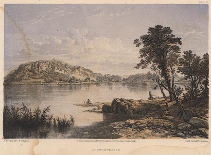 click to enlarge click to enlargePY21.jpg "Derwentwater" item:- JandMN : 97.19 Image © see bottom of page |
|
|
|
||
| evidence:- | outline view:- Black 1841 (3rd edn 1846) placename:- Lord's Isle |
|
| source data:- | Print, engraving, outline view, Mountains as seen at Lowdore Inn, and Mountains as
seen at the Third Gate on Ascending Latrigg on the Way to Skiddaw, by J Flintoft,
Keswick, Cumberland, engraved by R Mason, Edinburgh, Lothian, about 1846.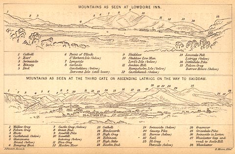 click to enlarge click to enlargeBC02E4.jpg "... Lord's Isle ..." item:- JandMN : 32.7 Image © see bottom of page |
|
|
|
||
| evidence:- | old print:- Tattersall 1836 (version 1869) placename:- outline view |
|
| source data:- | Print, hand coloured, Derwentwater and Bassenthwaite Lakes, from the road to Watendlath,
Cumberland, drawn by George Tattersall, 1836, engraved by W F Topham, published by
T J Allman, 463 Oxford Street, London, 1869.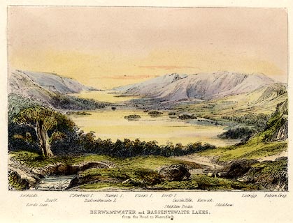 click to enlarge click to enlargeTAT212.jpg Included in The Lakes of England, by W F Topham. printed at bottom:- "DERWENTWATER and BASSENTHWAITE LAKES, / from the road to Watendlath." printed at bottom:- "Swinside. / Lord's Seat. / Barff. / St. Herbert's I. / Bassenthwaite L. / Ramps I. / Vicar's I. / Lord's I. / Skiddaw Dodd. / Castle Hill. / Keswick. / Skiddaw. / Latrigg. / Falcon Crag." item:- Armitt Library : A1067.12 Image © see bottom of page |
|
|
|
||
| evidence:- | outline view:- Tattersall 1836 placename:- Lord's Isle |
|
| source data:- | Print, engraving, Derwentwater and Bassenthwaite Lakes, from the road to Watenflath,
Cumberland, drawn by George Tattersall, engraved by W F Topham, published by Sherwood
and Co, Paternoster Row, London, about 1836.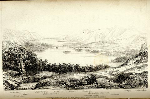 click to enlarge click to enlargeTAT130.jpg The print is captioned with mountain names and acts as an outline view. Tipped in opposite p.77 of The Lakes of England, by George Tattersall. printed at bottom:- "DERWENTWATER and BASSENTHWAITE LAKES, / from the road to Watendlath." printed at bottom left to right:- "Swinside. / Lord's Seat. / Barff. / St. Herbert's I. / Bassenthwaite L. / Ramp's I. / Vicar's I. / Lord's I. / Skiddaw Dodd. / Castle Hill. / Keswick. / Skiddaw. / Latrigg. / Falcon Crag." item:- Armitt Library : A1204.31 Image © see bottom of page |
|
|
|
||
| evidence:- | outline view:- placename:- Lord's Island |
|
| source data:- | Print, uncoloured engraving, Derwentwater and Bassenthwaite Lakes from the Road to
Watendlath, Cumberland, published by Sherwood and Co, London, 1836?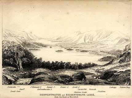 click to enlarge click to enlargePR0370.jpg The view is from just above Ashness Bridge. Objects in the view are identified by a caption at the bottom (unfortunately the print is pale, so some objects are unclear, and the caption seems to be a little misaligned) - Swinside, Lord's Seat, Barff, St. Herbert's I., Bassenthwaite L., Ramp's I., Vicar's I., Lord's I., Skiddaw Dodd, Castle Hill, Keswick, Skiddaw, Latrigg, Falcon Crag. printed at bottom:- "DERWENTWATER and BASSENTHWAITE LAKES. / from the Road to Watendlath." item:- Dove Cottage : 2008.107.370 Image © see bottom of page |
|
|
|
||
| hearsay:- |
The roman catholic family supported the Stuart cause in the rebellion of 1715, following
which Sir James Radcliffe, Lord Derwentwater, was captured and beheaded on Tower Hill,
London, 1716. That night there was a display of the Northern Lights, Aurora Borealis,
which came to be known as Derwentwater's Lights. |
|
| The family home was Dilston Hall, Northumberland, and there is a song about Lord Derwentwater's
death (from memory):- |
||
| "Farewell alas to Dilston Hall, my father's ancient seat, A stranger now must call thee his, which gars my heart to greet Farewell each friendly well known face, that I have known so well My tenants now must leave their lands or live their lves in fear." |
||
| "Farewell to you my bonny grey steed, which carried me aye so free; I wish I'd been sleepin' in my bed last time I mounted thee. Farewell, farewell, my lady dear, ill, ill thou counsell'd me No more again I'll see the babe that smiles upon your knee." |
||
| "The warning bell now bids me cease, my troubles will soon be o'er Yon sun that rises out the sea shall rise on me no more. Although that here in London town, I fated am to die, O, carry me to Northumberland, in my father's tomb to lie." |
||
|
|
||
| hearsay:- |
James Radcliffe, 3rd Earl of Derwentwater, married Anna Maria, daughter of Sir John
Webb, Canford, Dorset, 1712. The earl was a friend of The Pretender, and on the rising
of the 1715 Rebellion, a warrant was issued for his arrest. He went into hiding, but
the taunts of his wife persuaded him to active support for the rebellion. He was surrounded
at Preston, 14 October 1715, caught, sent to the Tower, beheaded 1716. Lady Derwentwater
visited the estate before retiring to Canford. She was blamed for her husband's death
and to escape the threats of the local population, she took refuge in a hollow on
Walla Crga, since known as Lady's Rake. |
|
|
|
||
| hearsay:- |
During the Civil War, Sir Francis Radcliffe fled from Northumberland to the island
to escape the Parliamentary forces, but his home on the island was destroyed in 1604
nevertheless. |
|
| Stone from the ruins is said to have been used to build Keswick's town hall. |
||
|
|
||
Lakes Guides menu.