 Old Cumbria Gazetteer
 |
 |
|
| milestone, Blindcrake (2) | ||
| site name:- | road, Cockermouth to Carlisle | |
| civil parish:- | Blindcrake (formerly Cumberland) | |
| county:- | Cumbria | |
| locality type:- | milestone | |
| coordinates:- | NY14903579 | |
| 1Km square:- | NY1435 | |
| 10Km square:- | NY13 | |
| references:- | OS County Series |
|
|
|
||
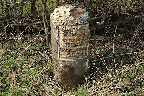 BSL15.jpg Cast iron plate on stone:- "CARLISLE 22 MILES / WIGTON 11 MILES / COCKERMOUTH 4½MILES" (taken 4.4.2010) |
||
|
|
||
| evidence:- | old map:- OS County Series (Cmd 46 5) |
|
| source data:- | Maps, County Series maps of Great Britain, scales 6 and 25
inches to 1 mile, published by the Ordnance Survey, Southampton,
Hampshire, from about 1863 to 1948. "M.S Carlisle .. 22 Wigton .. 11 Cockermouth .. 4 1/2" |
|
|
|
||
| evidence:- | database:- Listed Buildings 2010 |
|
| source data:- | courtesy of English Heritage "MILESTONE OPPOSITE MOOTA INN / / / BLINDCRAKE / ALLERDALE / CUMBRIA / II / 72557 / NY1490035787" |
|
| source data:- | courtesy of English Heritage "Milestone. Late C18 or early C19 for the Carlisle to Cockermouth turnpike. Whitewashed stone. Round-topped stone with curved face. Cast iron plate at front, inscribed CARLISLE 22 MILES, WIGTON 11 MILES, COCKERMOUTH 4 1/2 MILES; lettering picked out in black." |
|
|
|
||
 Lakes Guides menu.