Old Cumbria Gazetteer
 |
 |
|
||
| road, Brough to Reeth | ||||
| Brough to Reeth | ||||
| Reeth to Brough | ||||
| civil parish:- | Brough (formerly Westmorland) | |||
| civil parish:- | Brough Sowerby (formerly Westmorland) | |||
| civil parish:- | Stainmore (formerly Westmorland) | |||
| civil parish:- | Kaber (formerly Westmorland) | |||
| county:- | Cumbria | |||
| locality type:- | route | |||
| 10Km square:- | NY71 | |||
| 10Km square:- | NY81 | |||
| 10Km square:- | NY80 | |||
| county:- | North Yorkshire | |||
| 10Km square:- | NY80 | |||
| 10Km square:- | NY90 | |||
| 10Km square:- | NZ00 | |||
|
|
||||
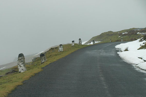 BSA04.jpg Road edge markers, in snow on the moors, (taken 22.1.2010) |
||||
|
|
||||
| evidence:- | possibly old map:- Cooper 1808 |
|||
| source data:- | Map, hand coloured engraving, Westmoreland ie Westmorland, scale
about 9 miles to 1 inch, by H Cooper, 1808, published by R
Phillips, Bridge Street, Blackfriars, London, 1808. click to enlarge click to enlargeCOP4.jpg double line; road item:- Dove Cottage : 2007.38.53 Image © see bottom of page |
|||
|
|
||||
| evidence:- | gradient diagram:- Gall and Inglis 1890s-1900s (Roads) |
|||
| source data:- | Contour Road Book of England, Northern Division, by Harry R G Inglis, published by
Gall and Inglis, 25 Paternoster Square, London and Edinburgh, 1898.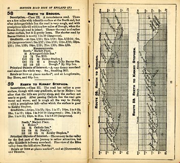 click to enlarge click to enlargeIG5058.jpg Itinerary, with gradient diagram, route 58, Reeth to Brough and route 59, Reeth to Kirkby Stephen, Yorkshire and Cumberland, 1898. item:- JandMN : 763.6 Image © see bottom of page |
|||
|
|
||||
| evidence:- | old strip map:- CTC 1911 (Roads) |
|||
| source data:- | Page 122 of Cyclists' Touring Club British Road Book new series vol.6, edited by F
B Sandford, published by Thomas Nelson and Sons, London etc, 1911.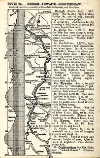 click to enlarge click to enlargeCTC2C2.jpg Strip road map, route 65, Brough Thwaite Oughtershaw, part of Brough to Beamsley, scale roughly 5 miles to 1 inch. Together with an itinerary and gradient diagram. item:- JandMN : 491.122 Image © see bottom of page |
|||
|
|
||||
| places:- |  Brough Barras, Stainmore Tan Hill, North Yorkshire Reeth, North Yorkshire Brough Barras, Stainmore Tan Hill, North Yorkshire Reeth, North Yorkshire |
|||
|
|
||||
| places:- |
|
|||
Lakes Guides menu.