 Old Cumbria Gazetteer
 |
 |
|
| St Constantine's Cells, Wetheral | ||
| St Constantine's Cells | ||
| Cells of St Constantine | ||
| Wetheral Safeguards | ||
| locality:- | Wetheral Woods | |
| civil parish:- | Wetheral (formerly Cumberland) | |
| county:- | Cumbria | |
| locality type:- | cave | |
| coordinates:- | NY46675354 (?) | |
| 1Km square:- | NY4653 | |
| 10Km square:- | NY45 | |
|
|
||
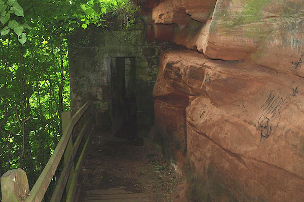 BPG95.jpg The present entrance to the caves. (taken 30.5.2008) 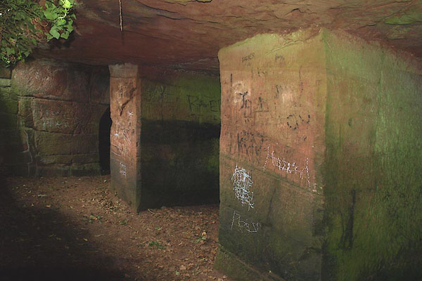 BPG96.jpg (taken 30.5.2008) |
||
| The photos were taken hand held with flash, which kills contrast, inscriptions disappear;
we were not expecting the inscriptions. If we can we'll go back with tripod and/or
offset flash. |
||
|
|
||
| evidence:- | old map:- OS County Series (Cmd 24 10) placename:- St Constantine's Cells |
|
| source data:- | Maps, County Series maps of Great Britain, scales 6 and 25
inches to 1 mile, published by the Ordnance Survey, Southampton,
Hampshire, from about 1863 to 1948. |
|
|
|
||
| evidence:- | descriptive text:- Simpson 1746 item:- cave; hermit's cave |
|
| source data:- | Atlas, three volumes of maps and descriptive text published as
'The Agreeable Historian, or the Compleat English Traveller
...', by Samuel Simpson, 1746. goto source goto source"... On the other Side of the River [from Corby Castle], over-against the House, are the remains of an old castle, which is called Weatherel-Tower, under which is an Hermit's Cave. ..." |
|
|
|
||
| evidence:- | old text:- Gents Mag |
|
| source data:- | Magazine, The Gentleman's Magazine or Monthly Intelligencer or
Historical Chronicle, published by Edward Cave under the
pseudonym Sylvanus Urban, and by other publishers, London,
monthly from 1731 to 1922. goto source Gentleman's Magazine 1761 p.501 "..." "Corby is remarkable for the pleasantness of its situation; and, opposite to it, on the other side of the Eden, Wetherall, where are some rooms dug out of the solid rock, in a place very difficult of ascent, supposed to have been the habitation of some hermit; or, perhaps, places of security for the Monks †to retire to in time of danger. ..." " †From the neighbouring monastery." |
|
|
|
||
| evidence:- | descriptive text:- Hearne and Byrne 1786 |
|
| source data:- | Book, Antiquities of Great Britain, prints from drawings by
Thomas Hearne, engraved by William Byrne, published by Hearne
and Byrne, London, 1786; published 1786-1807. "Near this Priory [Wetheral] are three remarkable Cells cut in the solid stone, communicating with each other by means of a gallery in front; these excavations are about midway, from the bottom to the summit of the rocks, rising 300 feet perpendicular above the river Eden, and are only accessible by means of ladders. They are said to have been made as a place of security for the Monks of this Priory, who were frequently obliged to retreat thither in times of danger, particularly during the incursions of the Scots." |
|
|
|
||
| evidence:- | old text:- Camden 1789 |
|
| source data:- | Book, Britannia, or A Chorographical Description of the Flourishing Kingdoms of England,
Scotland, and Ireland, by William Camden, 1586, translated from the 1607 Latin edition
by Richard Gough, published London, 1789. goto source Page 174:- "..." "... Wetheral ... where are certain cells cut out of a rock for places of retreat. ..." |
|
|
|
||
| evidence:- | old text:- Camden 1789 (Gough Additions) placename:- Constantine's Cells placename:- Safeguard, The |
|
| source data:- | Book, Britannia, or A Chorographical Description of the Flourishing Kingdoms of England,
Scotland, and Ireland, by William Camden, 1586, translated from the 1607 Latin edition
by Richard Gough, published London, 1789. goto source Page 191:- "..." "... in the midst of a vast precipice environed with woods are cut with much labour in the live rock three deep unroofed cells, divided by partitions of the same four feet thick, the front and entrance of fine cut stone; in front three windows and a fire-place. The cells, intended for security or retirement, are each 12 feet 8 inches deep, and about 9 feet 6 inches wide; below, before them, from the door to the end is a kind of gallery, 23 feet and an half long, bounded by the front, which overhangs the river Eden, above whose level they are 40 feet. There are marks of bolts and bars" goto sourcePage 192:- "to the windows, and of doors. The wall that forms the gallery founded on a ledge of rocks eight feet below the floor of the cells is ruined a little above their top, and was once joined to them by a roof. They are called Constantine's cells, the priory being dedicated to him, but more commonly the Safeguard, being probably intended as such for the neighbouring monks against the Scots, the door being approachable only by a ladder, and the whole only by a perpendicular ascent of seven feet from a long narrow path. ..." |
|
|
|
||
| evidence:- | descriptive text:- Ford 1839 (3rd edn 1843) placename:- Cells of St Constantine placename:- Wetheral Safeguards |
|
| source data:- | Guide book, A Description of Scenery in the Lake District, by
Rev William Ford, published by Charles Thurnam, Carlisle, by W
Edwards, 12 Ave Maria Lane, Charles Tilt, Fleet Street, William
Smith, 113 Fleet Street, London, by Currie and Bowman,
Newcastle, by Bancks and Co, Manchester, by Oliver and Boyd,
Edinburgh, and by Sinclair, Dumfries, 1839. goto source Page 120:- "... the cells of St. Constantine, excavated in the front of the precipice, forty feet above the raving flood below, and overhung by steep towering crags, overshadowed with trees, amid which the gnarled branches and roots of aged oaks are seen fantastically twisting forward. ..." goto sourcePage 122:- "..." "WETHERAL SAFEGUARDS." "The Caves of St. Constantine, or Wetheral Safeguards, may be explored. They are three in number, deeply excavated, and protected by a breastwork of masonry, in which is a fire-place and three small lights. There is now a wooden gallery, by which they are rendered accessible: formerly they were approached by a dangerous path from the bottom, and gained by a ladder, which was afterwards drawn up. Tradition says they were originally the retreat of an ascetic of the name of Constantine; but it is far more probable that they were formed by the monks of the priory, as places of safety in which to deposit their plate, vestments, and relics. Since then, they have undoubtedly been devoted to the same purposes by the inhabitants, as safeguards in the disturbed state of the Borders." "Further on is a summer-house, generally called the Folly, which presents a view of unrivalled magnificence. Far below, the Eden foams and thunders over its rocky channel, which here pursues a serpentine course; on either hand steep banks arise, hidden beneath the dense foliage of the Corby" goto sourcePage 123:- "and Wetheral woods. ..." |
|
|
|
||
| evidence:- | database:- Listed Buildings 2010 placename:- Safe Guards |
|
| source data:- | courtesy of English Heritage "SAFE GUARDS / / / WETHERAL / CARLISLE / CUMBRIA / I / 77778 / NY4668053538" |
|
| source data:- | courtesy of English Heritage "Cave dwellings. Early medieval, known to have been in use in the C14, probably for the Priory of Wetheral, but popularly considered to have been used by St Constantine when a hermit. 3 chambers cut high in the cliff face above the River Eden. Masonry front wall with 3 small windows and fireplace. Access would have originally been by ladder, but now has a stone cut path. Used by the Priory of Wetheral as a place of refuge during border raids and hence the name Safe Guards, (25 metres south of the caves is a Roman inscription, referring to the 20 legion Valeria Victrix, which was mentioned in the former listing)." |
|
|
|
||
| evidence:- | old print:- placename:- St Constantine's Cells item:- fishing |
|
| source data:- | Print, uncoloured engraving, St Constantine's Cells, Wetheral, Cumberland, from a
painting by L Clennell, engraved by J Greig, published by Longman and Co, Paternoster
Row, London, 1816.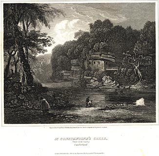 click to enlarge click to enlargePR0528.jpg Included in the Border Antiquities of England and Scotland. printed at bottom:- "Engraved by J. Greig, from a Painting by L. Clennell, for the Border Antiquities of England and Scotland. / St. Constantine's Cells, / (near Corby Castle.) / Cumberland. / London: Published Jan. 1. 1816, for the Proprietors, by Longman &Co. Paternoster Row." item:- Dove Cottage : 2008.107.477 Image © see bottom of page |
|
|
|
||
| evidence:- | old print:- placename:- Wetherel Cells |
|
| source data:- | Print, Plan of Wetherel Cells, St Constantine's Cells, Wetheral, by Moses Griffith,
engraved by Peter Mazell, about 1788?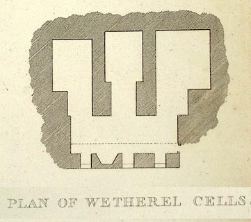 click to enlarge click to enlargePR1178.jpg inscribed at bottom centre on print, beneath lower images:- "PLAN OF WETHEREL CELLS." signed &inscribed at bottom left on print:- "Griffiths del." signed at bottom right on print:- "P Mazell sculp" item:- Tullie House Museum : 1976.169.2.7.2 Image © Tullie House Museum |
|
|
|
||
| evidence:- | old print:- placename:- Wetherel Cells |
|
| source data:- | Print, Wetherel Cells, St Constantine's Cells, Wetheral, Cumberland, by Moses Griffith,
engraved by Peter Mazell, about 1788?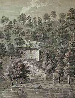 click to enlarge click to enlargePR1175.jpg Summertime; view of the 'cells' from the far bank of the river. inscribed at lower left, right, centre:- "Moses Griffiths del. / P Mazell sculp / WETHEREL CELLS." item:- Tullie House Museum : 1976.169.2.3.2 Image © Tullie House Museum |
|
|
|
||
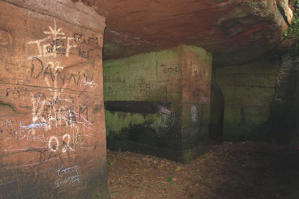 BPH04.jpg The easily inscribed sandstone is covered with names or initials and dates. You either deplore them all or accept them all; it's been going on for centuries. Tatty writing in chalk is a bit infra dig. (taken 30.5.2008) 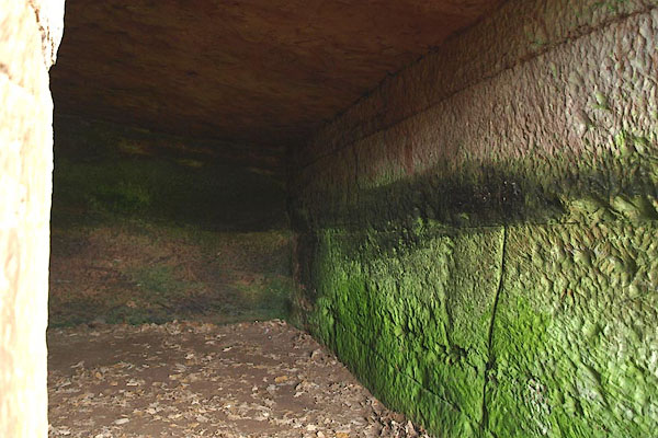 BPH05.jpg (taken 30.5.2008) 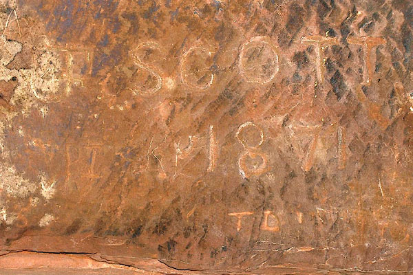 BPG97.jpg "SCOTT / 1871" (taken 30.5.2008) 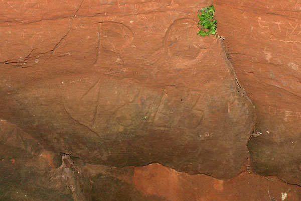 BPG94.jpg "R G / 1863" (taken 30.5.2008) 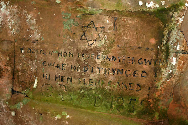 BPG92.jpg 1859, in Yiddish? (taken 30.5.2008) 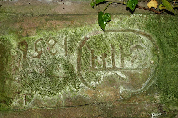 BPH03.jpg The inscription, 1859, is upsidedown (has the stone been reset?) It looks like the Devenagara script used for Maharathi etc. (taken 30.5.2008) 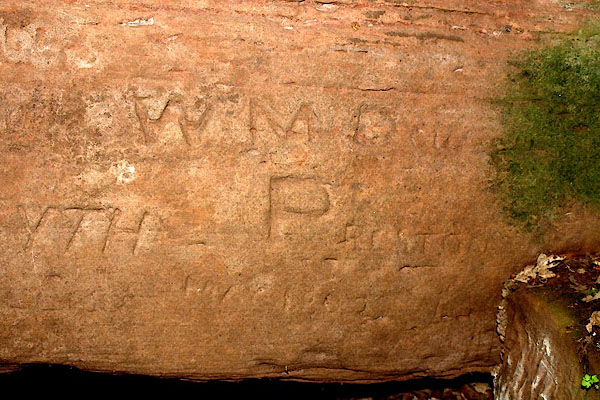 BPG93.jpg "1802" and other stuff. (taken 30.5.2008) 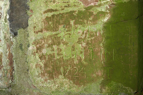 BPH02.jpg "[ ] 1724" (taken 30.5.2008) 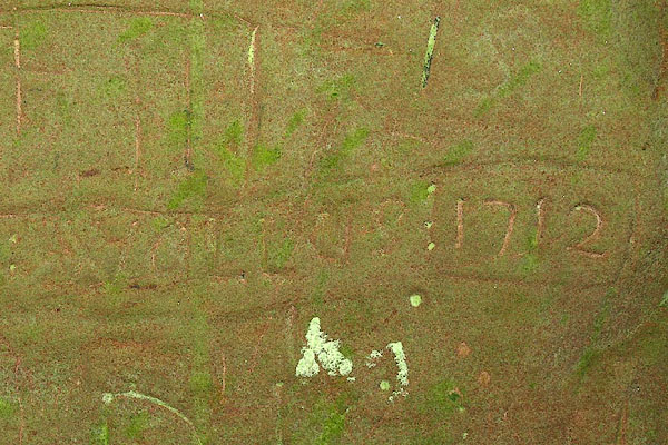 BPH01.jpg "[ ] 1712" (taken 30.5.2008) 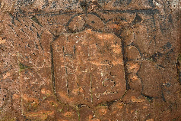 BPG98.jpg A sort of coat of arms. (taken 30.5.2008) 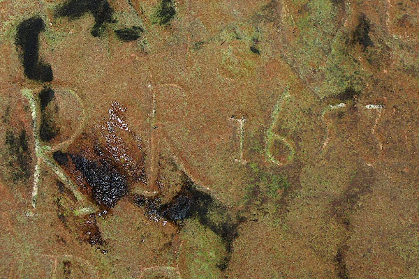 BPG99.jpg "R R 1653" Whilst I could go and write 1653 today, the style of numbers and letters looks fairly convincing for the 17th century. The earliest inscription we found. (taken 30.5.2008) |
||
|
|
||
Lakes Guides menu.