 Old Cumbria Gazetteer
 |
 |
|
|||||||||||||||||||||||||||||||||
| included in:- |
 road, Lancaster to Kirkby Stephen road, Lancaster to Kirkby Stephen |
||||||||||||||||||||||||||||||||||
| road, Lancaster to Kirkby Lonsdale | |||||||||||||||||||||||||||||||||||
| Lancaster to Kirkby Lonsdale | |||||||||||||||||||||||||||||||||||
| Kirkby Lonsdale to Lancaster | |||||||||||||||||||||||||||||||||||
| A683 | |||||||||||||||||||||||||||||||||||
| civil parish:- | Kirkby Lonsdale (formerly Westmorland) | ||||||||||||||||||||||||||||||||||
| county:- | Cumbria | ||||||||||||||||||||||||||||||||||
| locality type:- | road route | ||||||||||||||||||||||||||||||||||
| county:- | Lancashire | ||||||||||||||||||||||||||||||||||
|
|
|||||||||||||||||||||||||||||||||||
| evidence:- | old map:- OS County Series (Lan 20) |
||||||||||||||||||||||||||||||||||
| source data:- | Maps, County Series maps of Great Britain, scales 6 and 25
inches to 1 mile, published by the Ordnance Survey, Southampton,
Hampshire, from about 1863 to 1948. "SEDBERGH TRUST" along road |
||||||||||||||||||||||||||||||||||
|
|
|||||||||||||||||||||||||||||||||||
| evidence:- | old map:- Jefferys 1770 (Wmd) |
||||||||||||||||||||||||||||||||||
| source data:- | Map, 4 sheets, The County of Westmoreland, scale 1 inch to 1
mile, surveyed 1768, and engraved and published by Thomas
Jefferys, London, 1770.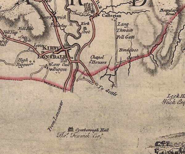 J5SD67NW.jpg "From Lancaster" double line; road, bold, main road item:- National Library of Scotland : EME.s.47 Image © National Library of Scotland |
||||||||||||||||||||||||||||||||||
|
|
|||||||||||||||||||||||||||||||||||
| evidence:- | road map:- Cary 1790 (Wmd/edn 1792) |
||||||||||||||||||||||||||||||||||
| source data:- | Road map, hand coloured engraving, Westmoreland, scale about
11.5 miles to 1 inch, by John Cary, 181 Strand, London, 1790,
edn 1792.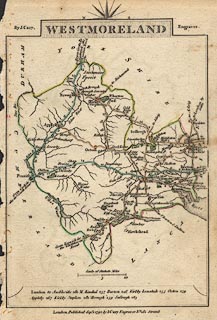 click to enlarge click to enlargeCY16.jpg "to Lancaster" double line item:- JandMN : 44 Image © see bottom of page |
||||||||||||||||||||||||||||||||||
|
|
|||||||||||||||||||||||||||||||||||
| evidence:- | road map:- Cary 1790 (Lan/edn 1792) |
||||||||||||||||||||||||||||||||||
| source data:- | Road map, hand coloured engraving, Lancashire, scale about 18
miles to 1 inch, by John Cary, 181 Strand, London, 1790, edn
1792.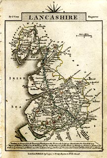 click to enlarge click to enlargeCY46.jpg two routes double line, with road distances from Lancaster item:- JandMN : 418 Image © see bottom of page |
||||||||||||||||||||||||||||||||||
|
|
|||||||||||||||||||||||||||||||||||
| evidence:- | road book:- Cary 1798 (2nd edn 1802) |
||||||||||||||||||||||||||||||||||
| source data:- | Road book, itineraries, Cary's New Itinerary, by John Cary, 181
Strand, London, 2nd edn 1802. goto source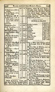 click to enlarge click to enlargeC38333.jpg page 333-334 "Near Kirkby Lonsdale, on l. a T.R. to Lancaster ..." part of London to Kendal through Halifax item:- JandMN : 228.1 Image © see bottom of page |
||||||||||||||||||||||||||||||||||
|
|
|||||||||||||||||||||||||||||||||||
| evidence:- | road book:- Cary 1798 (2nd edn 1802) |
||||||||||||||||||||||||||||||||||
| source data:- | Road book, itineraries, Cary's New Itinerary, by John Cary, 181
Strand, London, 2nd edn 1802. goto source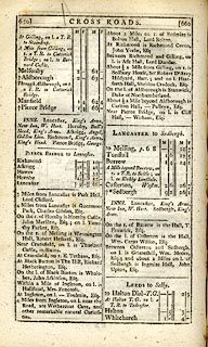 click to enlarge click to enlargeC38659.jpg page 659-660 "LANCASTER to Sedbergh." part of item:- JandMN : 228.2 Image © see bottom of page |
||||||||||||||||||||||||||||||||||
|
|
|||||||||||||||||||||||||||||||||||
| evidence:- | old map:- Cooke 1802 |
||||||||||||||||||||||||||||||||||
| source data:- | Map, Westmoreland ie Westmorland, scale about 12 miles to 1
inch, by George Cooke, 1802, published by Sherwood, Jones and
Co, Paternoster Road, London, 1824. click to enlarge click to enlargeGRA1Wd.jpg "to Lancaster" double line, light dark solid; road item:- Hampshire Museums : FA2000.62.4 Image © see bottom of page |
||||||||||||||||||||||||||||||||||
|
|
|||||||||||||||||||||||||||||||||||
| evidence:- | descriptive text:- Ford 1839 (3rd edn 1843) |
||||||||||||||||||||||||||||||||||
| source data:- | Guide book, A Description of Scenery in the Lake District, by
Rev William Ford, published by Charles Thurnam, Carlisle, by W
Edwards, 12 Ave Maria Lane, Charles Tilt, Fleet Street, William
Smith, 113 Fleet Street, London, by Currie and Bowman,
Newcastle, by Bancks and Co, Manchester, by Oliver and Boyd,
Edinburgh, and by Sinclair, Dumfries, 1839. goto source Page 154:- "II. LANCASTER TO KENDAL, BY KIRKBY-LONSDALE.- 30 MILES."
|
||||||||||||||||||||||||||||||||||
|
|
|||||||||||||||||||||||||||||||||||
| evidence:- | old strip map:- CTC 1911 (Roads) |
||||||||||||||||||||||||||||||||||
| source data:- | Page 102 of Cyclists' Touring Club British Road Book new series vol.6, edited by F
B Sandford, published by Thomas Nelson and Sons, London etc, 1911.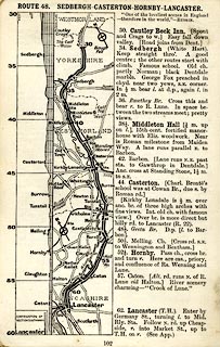 click to enlarge click to enlargeCTC2A2.jpg Strip road map, route 48, Sedbergh Casterton Hornby Lancaster, scale roughly 5 miles to 1 inch. Together with an itinerary and gradient diagram. item:- JandMN : 491.102 Image © see bottom of page |
||||||||||||||||||||||||||||||||||
|
|
|||||||||||||||||||||||||||||||||||
| places:- | Lancaster, Lancashire Claughton, Lancashire Hornby, Lancashire Melling, Lancashire Tunstall, Lancashire Nether Burrow, Lancashire Kirkby Lonsdale |
||||||||||||||||||||||||||||||||||
|
|
|||||||||||||||||||||||||||||||||||
| places:- |
|
||||||||||||||||||||||||||||||||||
Lakes Guides menu.