 Old Cumbria Gazetteer
 |
 |
|
| Castlerigg Stone Circle, St John's Castlerigg etc | ||
| Castlerigg Stone Circle | ||
| Castlerigg Circle | ||
| site name:- | Chestnut Hill | |
| civil parish:- | St John's Castlerigg and Wythburn (formerly Cumberland) | |
| county:- | Cumbria | |
| locality type:- | stone circle | |
| coordinates:- | NY29142363 | |
| 1Km square:- | NY2923 | |
| 10Km square:- | NY22 | |
|
|
||
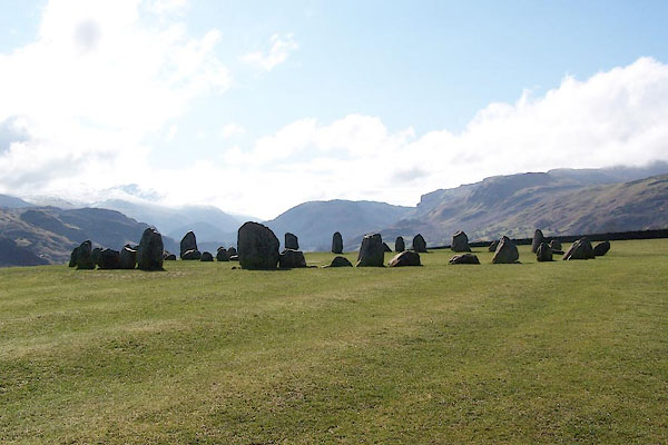 BQG50.jpg (taken 14.3.2009) 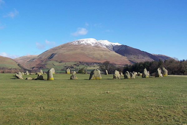 BQG49.jpg (taken 14.3.2009) |
||
|
|
||
| evidence:- | old map:- OS County Series (Cmd 64 7) placename:- Druidical Circle |
|
| source data:- | Maps, County Series maps of Great Britain, scales 6 and 25
inches to 1 mile, published by the Ordnance Survey, Southampton,
Hampshire, from about 1863 to 1948. |
|
|
|
||
| evidence:- | descriptive text:- placename:- Druid Stones |
|
| source data:- | Castlerigg Remembered by John Keats, from Hyperion book 2:- "Scarce images of life, one here, one there, Lay vast and edgeways; like a dismal cirque Of Druid stones, upon a forlorn moor, When the chill rain begins at shut of eve, In dull November, and their chancel vault, The Heaven itself, is blinded throughout night. Each one kept shroud, nor to his neighbour gave Or word, or look, or action of despair." |
|
|
|
||
| evidence:- | old map:- Donald 1774 (Cmd) placename:- Druid Stones |
|
| source data:- | Map, hand coloured engraving, 3x2 sheets, The County of Cumberland, scale about 1
inch to 1 mile, by Thomas Donald, engraved and published by Joseph Hodskinson, 29
Arundel Street, Strand, London, 1774.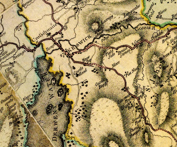 D4NY22SE.jpg "Druid Stones" circle of 7 spots item:- Carlisle Library : Map 2 Image © Carlisle Library |
|
|
|
||
| evidence:- | descriptive text:- West 1778 (11th edn 1821) |
|
| source data:- | Guide book, A Guide to the Lakes, by Thomas West, published by
William Pennington, Kendal, Cumbria once Westmorland, and in
London, 1778 to 1821. goto source goto sourcePage 110:- "... [from the front of Mr. Wren's house] In a field on the left, near the second mile-post, stands conspicuous, the above-mentioned wide circus of rude stones; the awful monument of the barbarous superstition which enslaved the minds of ancient times. Mr. Pennant had in his possession an excellent drawing of these druidical remains." goto sourceAddendum; Mr Gray's Journal, 1769 Page 208:- "... After dinner walked up the Penrith road two miles, or more, and turning into a cornfield to the right, called Castle-rigg, saw a druid circle of large stones, 108 feet in diameter, the biggest not eight feet high, but most of them still erect: they are fifty in number [1]." "[1] See this piece of antiquity more fully described, with a plate annexed, by Mr. Pennant, in his second tour of Scotland, 1772, page 38." |
|
|
|
||
| evidence:- | old map:- West 1784 map placename:- Druids Temple |
|
| source data:- | Map, hand coloured engraving, A Map of the Lakes in Cumberland,
Westmorland and Lancashire, scale about 3.5 miles to 1 inch,
engraved by Paas, 53 Holborn, London, about 1784.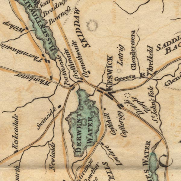 Ws02NY22.jpg Circle of seven dots near Castlerigg village. "Druids Temple" item:- Armitt Library : A1221.1 Image © see bottom of page |
|
|
|
||
| evidence:- | old text:- Clarke 1787 |
|
| source data:- | Guide book, A Survey of the Lakes of Cumberland, Westmorland,
and Lancashire, written and published by James Clarke, Penrith,
Cumberland, and in London etc, 1787; published 1787-93. goto source Page 62:- "About a quarter of a mile farther on the left is Castrigg, or Castle-Rigg: here is a druidical monument, consisting of a circle of fifty-two large stones. This temple (as they all commonly get that name) differs from all I have seen, in having on the Eastern side an inclosure formed within the circle; this inclosure is on the form of an oblong-square, one of the shorter sides of which is formed by part of the circle, and its dimensions are nearly four yards by two." "It is amazing how our rude forefathers could remove such large stones, and place them in regular order! The stones of which this is composed are of a kind not to be found within many miles of this place; it is situated upon a steep hill, and we know they were unacquainted with, not only the use of every mechanic power, but even of carriages: had they even known these, we know of no carriage capable of transporting, or even bearing the weight of these enormous masses." |
|
|
|
||
| evidence:- | old text:- Camden 1789 (Gough Additions) placename:- Carles |
|
| source data:- | Book, Britannia, or A Chorographical Description of the Flourishing Kingdoms of England,
Scotland, and Ireland, by William Camden, 1586, translated from the 1607 Latin edition
by Richard Gough, published London, 1789. goto source Page 181:- "..." "... In the neighbourhood of this place [Castlerigg], on the right hand of the road from Keswic to Penrith, is a collection of stones of unequal size" goto sourcePage 182:- "and shape, about 39 yards diameter, and on the east side within the circle or area two or more rows of like stones, including a space about eight yards by four. Stukely desribes it as very intire, 100 feet diameter, consisting of 40 stones, some very large. At the east end a grave, made of such other stones, in the very east point of the circle, and within it not a stone wanting, though some are removed out of their original situation. They call it the Carles, and corruptly Castle rigg. There seemed to be another lower in the next pasture towards the town." "..." "... About a mile and an half from Keswic on a high hill in a field called the Castle, is a druidical circle of stones, tending to an oval 35 yards diameter from north to south and near 30 from east to west. These stones are at present 40, but many fallen. At the north end are two five feet high; two more of nearly the same height at the south end, and one at the east near seven feet. On this side is the Kistvaen of great stones." |
|
|
|
||
| evidence:- | old text:- Capper 1808 |
|
| source data:- | Gazetteer, A Topographical Dictionary of the United Kingdom,
compiled by Benjamin Pitts Capper, published by Richard
Phillips, Bridge Street, Blackfriars, London, 1808; published
1808-29. goto source "[Keswick] ... About 2 miles from the town is a druidical monument, on a plain on the summit of a hill; it is composed of stones of various forms, rough and unhewn, for the most part granite. They are 50 in number, and form a circle of about 30 paces in diameter, within which are 10 stones placed in an oblong square, supposed to have been used as an altar. The stones are of various sizes, some of the largest being near 8 feet high, and 15 in circumference. ..." |
|
|
|
||
| evidence:- | old text:- Otley 1823 |
|
| source data:- | Site plan, woodcut? Castlerigg Stone Circle, by Jonathan Otley,
Keswick, Cumberland, 1830. goto source Page 81:- "THE ANTIQUITIES." "A Druidical Circle, 100 feet by 108 in diameter, in a field adjoining the old Penrith road, at the top of the hill, a mile and a half from Keswick." 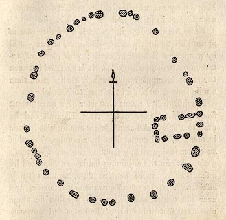 click to enlarge click to enlargeOT2E10.jpg "It is formed by rough cobble stones of various sizes, similar to what are scattered over the surface, and imbedded in the diluvium of the adjacent grounds. The largest stands upwards of seven feet in height, and may weigh about eight tons." item:- JandMN : 48.11 Image © see bottom of page |
|
|
|
||
| evidence:- | descriptive text:- Ford 1839 (3rd edn 1843) placename:- Druid's Circle |
|
| source data:- | Guide book, A Description of Scenery in the Lake District, by
Rev William Ford, published by Charles Thurnam, Carlisle, by W
Edwards, 12 Ave Maria Lane, Charles Tilt, Fleet Street, William
Smith, 113 Fleet Street, London, by Currie and Bowman,
Newcastle, by Bancks and Co, Manchester, by Oliver and Boyd,
Edinburgh, and by Sinclair, Dumfries, 1839. goto source Page 59:- "..." "THE DRUID'S CIRCLE." "'A few rude monuments of mountain stone Survive: all else is swept away.'" "This religious monument is situated on the top of a lone hill, one mile and three quarters on the road from Keswick to Penrith, in the centre of the loftiest mountains in the district, away from the sight and sound of human life. It occupies a circular area three hundred and thirty-six feet in circumference, and one hundred and fourteen feet in diameter, surrounded by thirty-eight granite stones" goto sourcePage 60:- "from three to eight feet high, having at the east end ten other stones, forming three sides of a square. From these stones is seen the whole encircling country; Skiddaw and Blencathra to the north present their deep-chasmed and precipitous fronts; the Dodds, Wanthwaite Pikes, with the savage dale of Naddle, shut up the scene to the south; and to the west, the fells beyond Keswick rear their majestic and undulating summits to the clouds; whilst on the east, the dreary waste of Hutton Moor is over-topped by the blue summit of Cross Fell. It was amidst such scenes as these that the Druid sage warmed into piety the hardy tempers of the Britons, and employed the solemnity of nature to aid the sanctity of religion: for" "'There his temple rose! no fretted aisle, No vaulted roof adorn'd the simple pile, But clouds above them, and around the wood - Roofless and vast the circle columns stood! Such relics still the wondering shepherd sees Where ocean rocks the storm-clad Hebrides: Where Keswick's lake expands its glassy breast, Or Mona's cliffs conceal the eaglet's nest; Or where dim silence holds its spectral reign, O'er Scotia's heaths and Sarum's lonely plain. Times spares them still - to tell how short the span Assign'd to earth's uncertain wanderer - man; How long his works, like summer's twilight ray, Outlive the sunset of his own decay!'" |
|
|
|
||
| evidence:- | old map:- Ford 1839 map placename:- Druid Stones |
|
| source data:- | Map, uncoloured engraving, Map of the Lake District of
Cumberland, Westmoreland and Lancashire, scale about 3.5 miles
to 1 inch, published by Charles Thurnam, Carlisle, and by R
Groombridge, 5 Paternoster Row, London, 3rd edn 1843.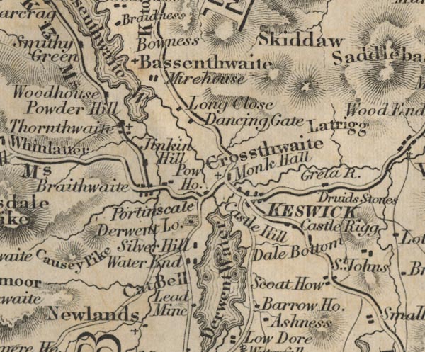 FD02NY22.jpg "Druid Stones" item:- JandMN : 100.1 Image © see bottom of page |
|
|
|
||
| evidence:- | old drawing:- Aspland 1840s-60s placename:- Druid Stones |
|
| source data:- | Drawing, pencil, Castlerigg Stone Circle, Cumberland, by Theophilus Lindsey Aspland,
September 1845.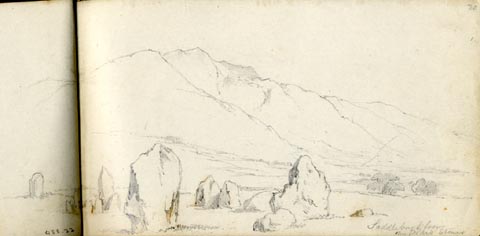 click to enlarge click to enlargeAS0222.jpg "Saddleback from / the Druid Stones" page number "20" item:- Armitt Library : 1958.488.22 Image © see bottom of page |
|
|
|
||
| evidence:- | old text:- Gents Mag |
|
| source data:- | Magazine, The Gentleman's Magazine or Monthly Intelligencer or
Historical Chronicle, published by Edward Cave under the
pseudonym Sylvanus Urban, and by other publishers, London,
monthly from 1731 to 1922. goto source Gentleman's Magazine 1843 part 2 p.362 "... The situation and aspect of the Druidical temple near Keswick is in every respect similar to this [Swwinside], except the rectangular recess, formed by ten large stones, which is peculiar to Keswick." |
|
|
|
||
| evidence:- | old map:- Garnett 1850s-60s H placename:- Druid Stones |
|
| source data:- | Map of the English Lakes, in Cumberland, Westmorland and
Lancashire, scale about 3.5 miles to 1 inch, published by John
Garnett, Windermere, Westmorland, 1850s-60s.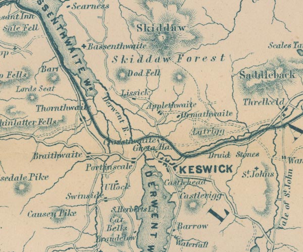 GAR2NY22.jpg "Druid Stones" no symbol item:- JandMN : 82.1 Image © see bottom of page |
|
|
|
||
| evidence:- | old print:- Pyne 1853 placename:- Druidical Circle |
|
| source data:- | Print, tinted lithograph, Druidical Circle, Keswick, Cumberland, by James Baker Pyne,
engraved by W Gauci, published by Thomas Agnew and Sons, Manchester, Lancashire, 1853.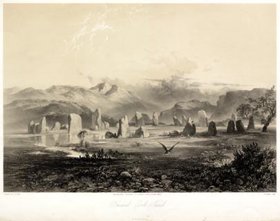 click to enlarge click to enlargePYN214.jpg "PAINTED BY J. B. PYNE. / W. GAUCI LITH. / MANCHESTER, PUBLISHED BY THOMAS AGNEW & SONS, 1853. / Druidical Circle, Keswick. / M & N HANHART IMPT." item:- Armitt Library : A6678.15 Image © see bottom of page |
|
|
|
||
| evidence:- | old text:- Martineau 1855 item:- sacrifice; treasure; counting a stone circle |
|
| source data:- | Guide book, A Complete Guide to the English Lakes, by Harriet
Martineau, published by John Garnett, Windermere, Westmorland,
and by Whittaker and Co, London, 1855; published 1855-76. goto source Page 94:- "... the Druids' Temple, a mile and a-half from Keswick. This very well-preserved memorial of antiquity stands in a field, near the entrance of St. John's Vale. The stones, forty-eight in number, form an oval; and there is a peculiarity in this case which distinguishes it from all other Druidical monuments extant in England. On the eastern side, within the circle, there is a small recess formed by ten stones, making an oblong square. As Southey observed, the spot is the most commanding that could be chosen, short of a mountain side; and it is indeed nearly surrounded by mountains, which it recognises in their true forms, from the levels,- with the exception of the plain towards Penrith,- being sunk out of view. The old legend about the last human sacrifice of the Druids may belong to any of the monuments of that age in the district; and it is probably claimed for them all. According to that old story; when some people settled in a clearing of the woods, beside a river, somewhere to the south of the district, the priests took up their station further north, among the mountains, where there were plenty of stones fit and ready for their temple. After a time, a fever laid waste the lower" goto sourcePage 95:- "settlement; and the oracle demanded a sacrifice to appease the divine wrath. The lot fell on a young girl who was betrothed: and, on an appointed day, she was conveyed, with all the ceremonies, to the temple. A small hut of wickerwork, like a large beehive, was found set up on the western side of the temple. The girl was led into the circle, and placed in the midst, while the dedication proceeded. We are even told that she was adorned with an oak garland, and held mistletoe in her hand. The whole population was looking on from a distance: but it must have been within reasonable reach, as every one was required to contribute a stick to the fire. The wretched lover saw all from afar; and he daringly resolved,- let the god be as wrathful as he pleased,- not to contribute so much as a twig to the burning of his beloved. She was seen to enter the door, which was next the circle; and then the priest closed it up, and heaped the dried leaves and sticks that were brought all round the hut. The arch-druid meantime was procuring fire from two pieces of wood. He succeeded, and set the pile in a blaze. In this moment of desperation, the lover saw every mountain round give forth a great cataract; and all the floods gushed to the temple as to a centre, and made an island of the little hut,- returning when they had extinguished the fire. The victim came forth, with not a hair singed, and not a leaf of her garland withered. The arch-druid, skilled to interpret thunder, seems to have understood in this case the voice of waters; for he announced that, henceforth, the god would have no more human sacrifices. Any resident who is sufficiently familiar with" goto sourcePage 96:- "the country people to get them to speak their minds fully, will find that they still hold to the notion that nobody can count the druid stones correctly; and also that a treasure is buried under the largest stone. As to the first, there are, in most such circles, some smaller stones cropping out of the ground which some visitors will, and others will not, include among those of the circle. ... As for the treasure, can any one prove that it is not there? Nobody wants to undermine the stone, to get rid of the tradition: so our neighbours are like the Arabs at Petra, who have been shooting with sling, bow, and matchlock, for a thousand years, at the urn, where they are sure Pharaoh's treasure is,- in its niche in the rock temple. For a thousand years, they have failed to bring it down, and are determined that no European shall. And no European would dismantle the temple to disabuse the Arabs; and so the tradition and the urn stand untouched. So may it be for ages to come with ... the giant of eight tons' weight that presides over the Keswick circle!" |
|
|
|
||
| evidence:- | old photograph:- Bell 1880s-1940s |
|
| source data:- | Photograph, sepia, Castlerigg Stone Circle, St John's Castlerigg and Wythburn, Cumberland,
by Herbert Bell, photographer, Ambleside, Westmorland, 1890s.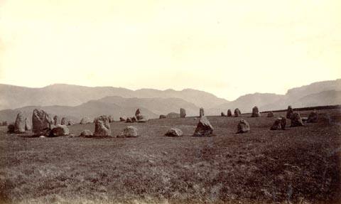 click to enlarge click to enlargeHB0619.jpg item:- Armitt Library : ALPS279 Image © see bottom of page |
|
|
|
||
| evidence:- | old print:- Heaton Cooper 1905 (edn 1908) placename:- Druid Circle item:- moonlight |
|
| source data:- | Print, colour halftone, Druid Circle, near Keswick, moonlight, Castlerigg Stone Circle,
St John's Castlerigg and Wythburn, Cumberland, from a watercolour painting by Alfred
Heaton Cooper, published by Adam and Charles Black, London, 2nd edn 1908.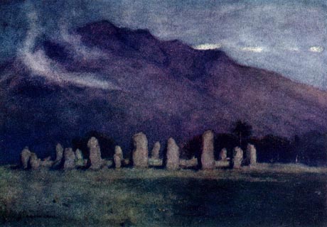 click to enlarge click to enlargeHC0151.jpg Opposite p.150 of The English Lakes, painted by Alfred Heaton Cooper, described by William T Palmer. printed at tissue opposite the print:- "DRUID CIRCLE, NEAR KESWICK / Moonlight" item:- JandMN : 468.51 Image © see bottom of page |
|
|
|
||
| evidence:- | old print:- Pearson 1900s placename:- Druidical Circle, The |
|
| source data:- | Print, halftone photograph, The Druidical Circle, near Keswick, Castlerigg Stone Circle,
St John's Castlerigg and Wythburn, Cumberland, published by C Arthur Pearson, Henrietta
Street, London, 1900s.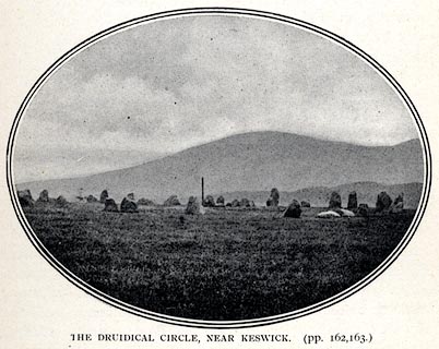 click to enlarge click to enlargePS1E60.jpg On p.163 of Pearson's Gossipy Guide to the English Lakes and Neighbouring Districts. printed at bottom:- "THE DRUIDICAL CIRCLE, NEAR KESWICK (pp.162, 163)." item:- Armitt Library : A1188.67 Image © see bottom of page |
|
|
|
||
| evidence:- | old print:- Bogg 1898 |
|
| source data:- | Print, engraving, Druidical Circle ie Castlerigg Stone Circle, St John's Castlerigg
and Wythburn, Cumberland, by P M Teesdale, published by Edmund Bogg, 3 Woodhouse Lane,
and James Miles, Guildford Street, Leeds, Yorkshire, 1898.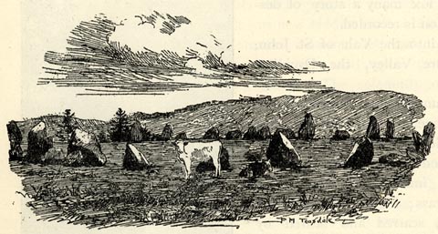 click to enlarge click to enlargeBGG147.jpg Included on p.154 of Lakeland and Ribblesdale, by Edmund Bogg. item:- JandMN : 231.47 Image © see bottom of page |
|
|
|
||
| evidence:- | old print:- Sylvan 1847 placename:- Druid's Circle |
|
| source data:- | Print, engraving, Druid's Circle near Keswick, Castlerigg Stone Circle, Cumberland,
published by John Johnstone, Paternoster Row, London, et al, 1847.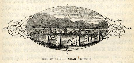 click to enlarge click to enlargeSYL145.jpg On p.189 of Sylvan's Pictorial Guide to the English Lakes. printed at bottom:- "DRUID'S CIRCLE NEAR KESWICK" item:- Armitt Library : A1201.45 Image © see bottom of page |
|
|
|
||
| evidence:- | old print:- Rose 1832-35 (vol.3 no.36) placename:- Druids' Stones |
|
| source data:- | Print, uncoloured engraving, Druids' Stones, near Keswick, Castlerigg, Cumberland,
drawn by Thomas Allom, engraved by H Adlard, published by Fisher, Son and Co, London,
1832-35.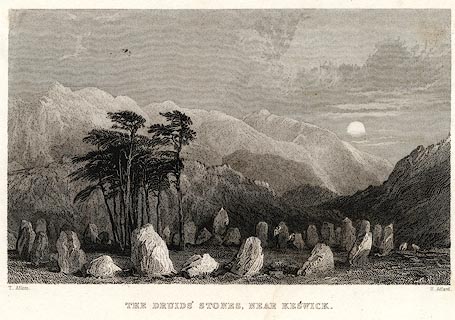 click to enlarge click to enlargePR0045.jpg vol.3 pl.36 in the set of prints, Westmorland, Cumberland, Durham and Northumberland Illustrated. printed at bottom left, right, centre:- "T. Allom. / H. Adlard. / DRUIDS' STONES, NEAR KESWICK." item:- Dove Cottage : 2008.107.45 Image © see bottom of page |
|
|
|
||
| evidence:- | old print:- Otley 1823 (8th edn 1849) placename:- Druidical Circle |
|
| source data:- | Print, engraving, Druidical Circle near Keswick, ie Castlerigg Stone Circle, St John's
Castlerigg and Wythburn, drawn by Mr Binns, Halifax, engraved by Mr Jewitt, Headington,
Oxfordshire, published by Jonathan Otley, Keswick, Cumberland et al, 1849.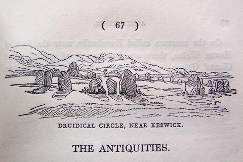 click to enlarge click to enlargeO80E18.jpg On p.67 of A Descriptive Guide of the English Lakes, by Jonathan Otley, 8th edition, 1849. item:- Armitt Library : A1180.19 Image © see bottom of page |
|
|
|
||
| evidence:- | old print:- Lowther 1780s-90s placename:- Druid's Monument |
|
| source data:- | Print, engraving, Druid's Monument near Keswick, Cumbria, late 18th century.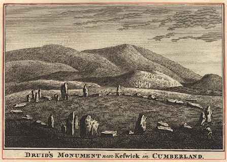 click to enlarge click to enlargeBMZ94.jpg Pasted in the Lowther scrapbook, vol.3; between pp.90-91. printed at bottom:- "DRUID'S MONUMENT near Keswick in CUMBERLAND" item:- Dove Cottage : Lowther.60 Image © see bottom of page |
|
|
|
||
| evidence:- | old print:- Lowther 1780s-90s |
|
| source data:- | Print, engraving, Druidical Remains, ie Castlerigg Stone Circle, St John's Castlerigg
and Wythburn, late 18th century.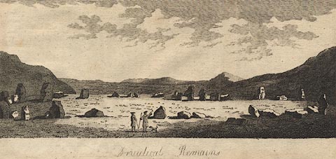 click to enlarge click to enlargeBMZ02.jpg This image is engraved on the same plate as Long Meg and her Daughters. Pasted in the Lowther scrapbook, vol.3; between pp.90-91. printed at bottom:- "Druidical Remains" item:- Dove Cottage : Lowther.57 Image © see bottom of page |
|
|
|
||
 Click to enlarge BQG51.jpg (taken 14.3.2009) 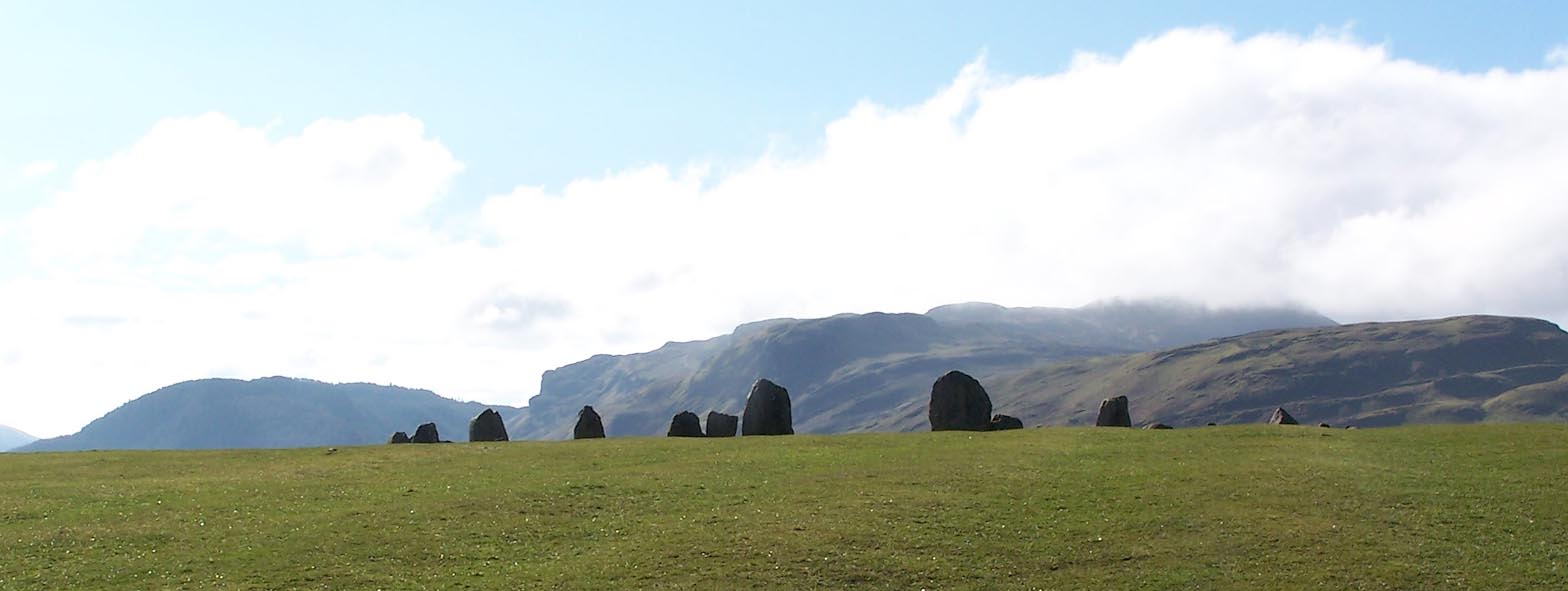 Click to enlarge BQG52.jpg (taken 14.3.2009) 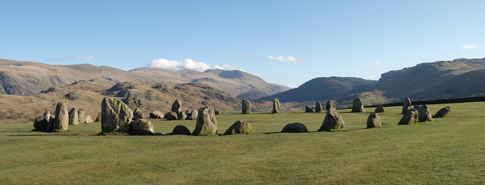 Click to enlarge BUF98.jpg (taken 18.3.2011) 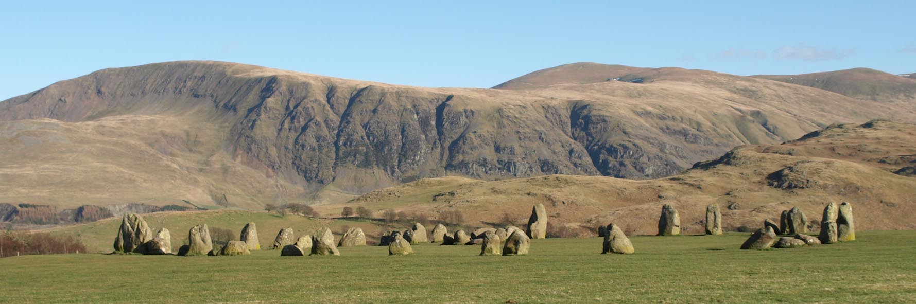 Click to enlarge BUF99.jpg (taken 18.3.2011)  Click to enlarge BUG32.jpg All round from the middle. (taken 18.3.2011) |
||
|
|
||
| hearsay:- |
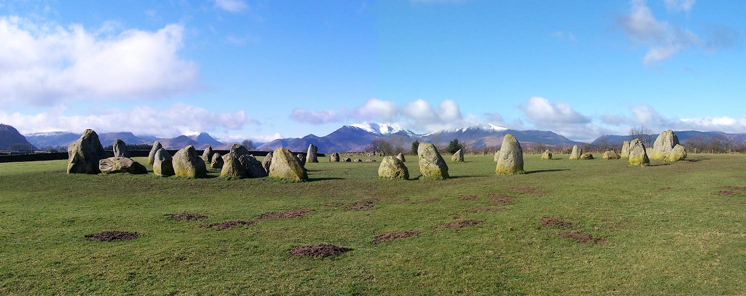
Flatened circle Thom type A; shows seven solar and lunar declinations. |
|
| 38 stones left of 42, ring 32.6x29.9m |
||
| William Stukeley wrote of a second stone circle in the next field towards Keswick;
there is no trace of this. |
||
| Waterhouse, John: 1985: Stone Circles of Cumbria: Phillimore and Co (Chichester, Sussex)::
ISBN 0 85033 566 3 Thom, A: 1967: Megalithic Sites in Britain: Oxford University Press (Oxford, Oxfordshire) Burl, H A W: 1976: Stone Circles of the British Isles: Yale University Press (United States) |
||
|
|
||
| notes:- |
Various marked stones; also a cup marked stone in the field wall. |
|
| Becckensall, Stan: 2002: Prehistoric Rock Art in Cumbria: Tempus Publishing (Stroud,
Gloucestershire) |
||
|
|
||
| person:- | : National Trust |
|
|
|
||
| person:- | : English Heritage |
|
|
|
||
Lakes Guides menu.