 Old Cumbria Gazetteer
 |
 |
|
| St John's in the Vale | ||
| civil parish:- | St John's Castlerigg and Wythburn (formerly Cumberland) | |
| county:- | Cumbria | |
| locality type:- | valley | |
| coordinates:- | NY31602251 (etc) | |
| 1Km square:- | NY3122 | |
| 10Km square:- | NY32 | |
|
|
||
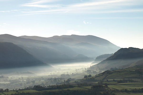 BXN75.jpg (taken 21.10.2012) 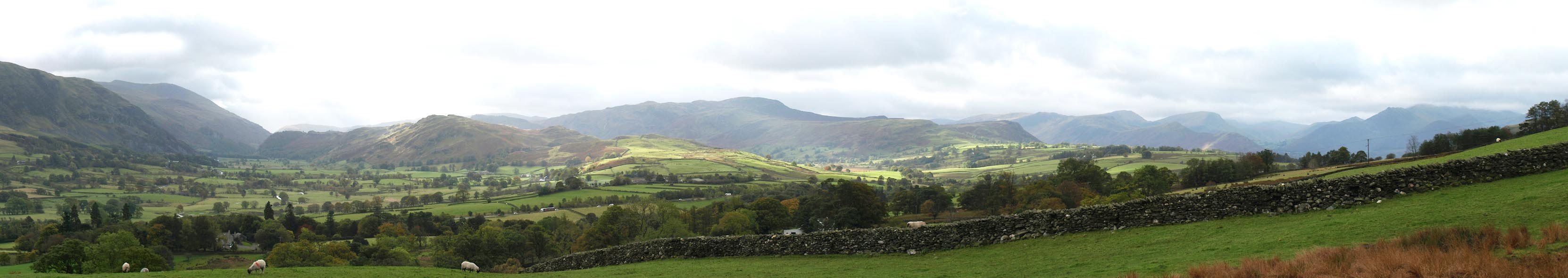 Click to enlarge BXM57.jpg From above Threlkeld. (taken 12.10.2012) |
||
|
|
||
| evidence:- | old map:- Saxton 1579 placename:- St Johns |
|
| source data:- | Map, hand coloured engraving, Westmorlandiae et Cumberlandiae Comitatus ie Westmorland
and Cumberland, scale about 5 miles to 1 inch, by Christopher Saxton, London, engraved
by Augustinus Ryther, 1576, published 1579-1645.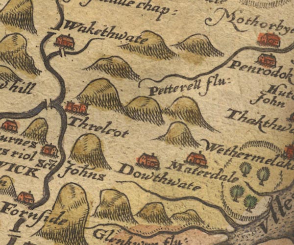 SAX9NY32.jpg circle, building "Sct Johns" item:- private collection : 2 Image © see bottom of page |
|
|
|
||
| evidence:- | old map:- Speed 1611 (Cmd) placename:- St John's |
|
| source data:- | Map, hand coloured engraving, Cumberland and the Ancient Citie
Carlile Described, scale about 4 miles to 1 inch, by John Speed,
1610, published by J Sudbury and George Humble, Popes Head
Alley, London, 1611-12.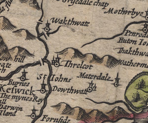 SP11NY32.jpg "St. Johns" circle, tower item:- private collection : 16 Image © see bottom of page |
|
|
|
||
| evidence:- | old map:- Jansson 1646 placename:- St Johns |
|
| source data:- | Map, hand coloured engraving, Cumbria and Westmoria, ie
Cumberland and Westmorland, scale about 3.5 miles to 1 inch, by
John Jansson, Amsterdam, Netherlands, 1646.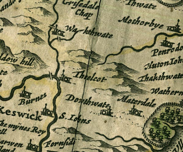 JAN3NY32.jpg "S. Iohns" Buildings and tower. item:- JandMN : 88 Image © see bottom of page |
|
|
|
||
| evidence:- | old map:- Morden 1695 placename:- St Johns |
|
| source data:- | Map, uncoloured engraving, Cumberland, scale about 4 miles to 1
inch, by Robert Morden, 1695, published by Abel Swale, the
Unicorn, St Paul's Churchyard, Awnsham, and John Churchill, the
Black Swan, Paternoster Row, London, 1695-1715.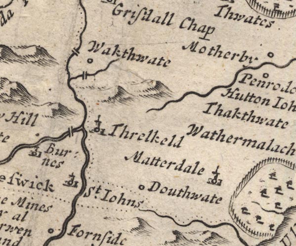 MD12NY32.jpg circle, building, tower "St. Johns" item:- JandMN : 90 Image © see bottom of page |
|
|
|
||
| evidence:- | old text:- Gents Mag |
|
| source data:- | Magazine, The Gentleman's Magazine or Monthly Intelligencer or
Historical Chronicle, published by Edward Cave under the
pseudonym Sylvanus Urban, and by other publishers, London,
monthly from 1731 to 1922. goto source goto sourceGentleman's Magazine 1755 p.6:- "During the lightnings mentioned in your last Mag. (See Vol. xxiv. p.571) 3 men were walking thro' St John's vale, over which the clouds, being pent in betwixt the high mountains, hung pretty low, and the lightnings were very frequent. The vale is about 500 yards wide, and two miles long, and after they had walked about a mile, one of them complained suddenly of uncommon oppression in his lungs, and presently afterwards dropt down dead. After some uneffectual attempts to recover and remove him, the survivors being alarmed by the approach of night, and the encrease of the tempest, went on as fast as they could. Soon after one of these made the same complaint, and almost instantly fell down dead, as the other had done: The third was now struck with astonishment and terror, and solicitude for himself suppressed for the present his concern for others; he immediately began to run, and expected every step to be his last, as he felt the same oppression on his breast, which every moment increased, however this went off after he had gone about a quarter of a mile, and he ran into to the first house pale, trembling, and exhaused, and as soon as he could speak directed the people to seek and succour his companions, whom they soon found, but all attempts to recover them proved ineffectual. G.S." |
|
|
|
||
| evidence:- | descriptive text:- West 1778 (11th edn 1821) placename:- St John's Vale placename:- Vale of St John placename:- Nadale |
|
| source data:- | Guide book, A Guide to the Lakes, by Thomas West, published by
William Pennington, Kendal, Cumbria once Westmorland, and in
London, 1778 to 1821. goto source Addendum; Mr Gray's Journal, 1769 Page 202:- "..." "Oct. 2. I set out at ten for Keswick [from Penrith], ... The broad and green vallies of Gardies and Lowside, with a swift stream glittering among the cottages and meadows, lay to the left, and the much finer, but narrower valley of St. John, opening into it: ..." goto sourcePage 208:- "... [from Castlerigg] The valley of St. John appeared in sight, ..." goto sourceMrs Radcliffe's Ride over Skiddaw, 1794 Page 305:- "..." "At length, as we ascended, ... An opening to the south, at length, showed the whole plan of the narrow vales of St. John and of Nadale, separated by the dark ridge of rocks called St. John's Rigg, with each its small line of verdure at the bottom, and bounded by enormous grey fells, which we were, however, now high enough to overlook. A white speck on the top of St. John's Rigg, was pointed out by the guide to be a chapel of ease to Keswick, ... From this chapel, dedicated to St. John, the rock and the vale have received their name; and our guide told us that Nadale was frequently known by the same title." |
|
|
|
||
| evidence:- | old painting:- Green 1790s-1820s (?) |
|
| source data:- | Painting, watercolour, Rake How near Thirlmere, St John's Castlerigg and Wythburn,
Cumberland, attributed to William Green, Ambleside, Westmorland, 1800s-20s?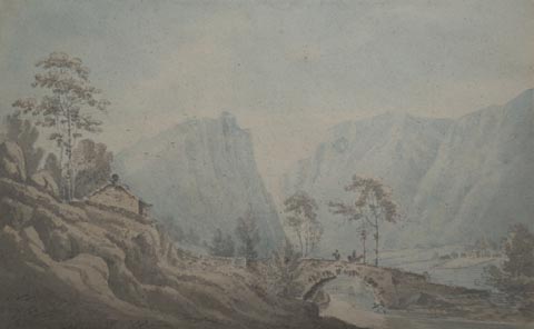 click to enlarge click to enlargePR1725.jpg courtesy of Abbot Hall Art Gallery, Kendal item:- Abbot Hall : SO32.94 Image © see bottom of page |
|
|
|
||
| evidence:- | old print:- Green 1804 (plate 11) placename:- St John's Vale |
|
| source data:- | Print, uncoloured aquatint, St John's Vale from Leathes Park, St John's Castlerigg
and Wythburn, Cumberland, by William Green, Ambleside, Westmorland, 1804.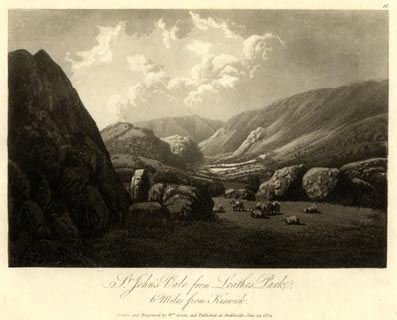 click to enlarge click to enlargeGN1611.jpg Plate 11 from a series. printed at bottom:- "St John's Vale from Leathes Park, / 6 Miles from Keswick. / Drawn and Engraved by Wm. Green, and Published at Ambleside, June 24, 1804." printed at top right:- "11" item:- Armitt Library : 2014.158 Image © see bottom of page |
|
|
|
||
| evidence:- | old print:- Green 1810 (plate 27) placename:- St John's Vale |
|
| source data:- | Print, soft ground etching, St John's Vale, St John's Castlerigg and Wythburn, Cumberland,
by William Green, Ambleside, Westmorland, 1808.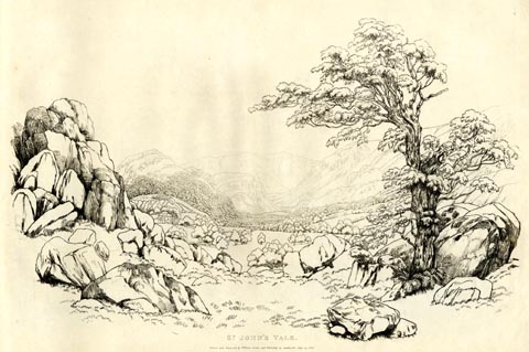 click to enlarge click to enlargeGN1227.jpg Plate 27 in Sixty Studies from Nature, 1810. printed at top right:- "27" printed at bottom:- "ST. JOHN'S VALE. / Drawn and Engraved by William Green, and Published at Ambleside, June 24, 1808." watermark:- "J WHATMAN / 1813" item:- Armitt Library : A6641.27 Image © see bottom of page |
|
|
|
||
| evidence:- | old print:- Wilkinson 1810 (plate 20) placename:- St John's Vale |
|
| source data:- | Print, uncoloured soft ground etching, View in St John's Vale, with Green Crag etc,
Cumberland, by Joseph Wilkinson, engraved by William Frederick Wells, published by
R Ackermann, Repository of Arts, 101 Strand, London, 1810.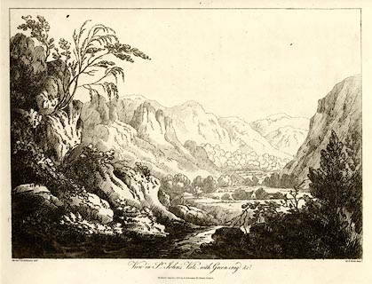 click to enlarge click to enlargeWKN120.jpg Plate 20 in Select Views in Cumberland, Westmoreland, and Lancashire. printed at bottom left, right, centre:- "The Revd. Jos: Wilkinson delt. / W. F. Wells Sculpt. / View in St. John's Vale, with Green-crag &c. / Publish'd March 1. 1810. by R. Ackerman. 101. Strand. London." item:- Fell and Rock Climbing Club : MN4.20 Image © see bottom of page |
|
|
|
||
| evidence:- | old print:- Wilkinson 1810 (plate 21) placename:- St John's Vale |
|
| source data:- | Print, uncoloured soft ground etching, View in St John's Vale, near Wanthwaite, Cumberland,
by Joseph Wilkinson, engraved by William Frederick Wells, published by R Ackermann,
Repository of Arts, 101 Strand, London, 1810.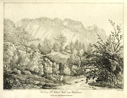 click to enlarge click to enlargeWKN121.jpg Plate 21 in Select Views in Cumberland, Westmoreland, and Lancashire. printed at bottom left, right, centre:- "The Revd. Jos. Wilkenson delt. / W. F. Wells sculpt. / View in St. John's Vale, near Wanthwaite. / Publish'd April 1. 1810. by R. Ackermann. 101. Strand. London." item:- Fell and Rock Climbing Club : MN4.21 Image © see bottom of page |
|
|
|
||
| evidence:- | old print:- Green 1814 (plate 28) placename:- St John's Vale item:- chimney |
|
| source data:- | Print, uncoloured soft ground etching, Cottage in St John's Vale, St John's Castlerigg
and Wythburn, Cumberland, by William Green, Ambleside, Westmorland, 1814.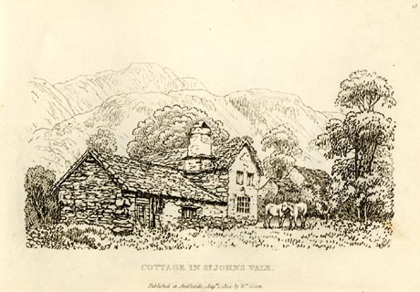 click to enlarge click to enlargeGN0928.jpg S of Sosgill Bridge; unidentified. Plate 28 in Sixty Small Prints. printed at top right:- "28" printed at bottom:- "COTTAGE IN ST JOHN'S VALE. / Published at Ambleside Augst. 1, 1814, by Wm. Green." item:- Armitt Library : A6656.28 Image © see bottom of page |
|
|
|
||
| evidence:- | old print:- Green 1814 (plate 28) placename:- St John's Vale item:- chimney |
|
| source data:- | Print, tinted soft ground etching, Cottage in St John's Vale, St John's Castlerigg
and Wythburn, Cumberland, by William Green, Ambleside, Westmorland, 1814.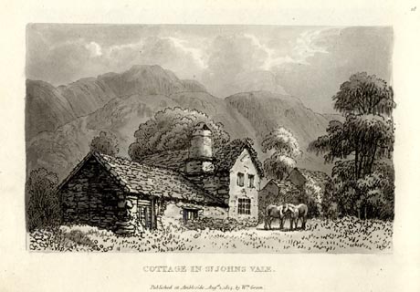 click to enlarge click to enlargeGN1028.jpg S of Sosgill Bridge; unidentified. Plate 28 in Sixty Small Prints. printed at top right:- "28" printed at bottom:- "COTTAGE IN ST JOHN'S VALE. / Published at Ambleside Augst. 1, 1814, by Wm. Green." item:- Armitt Library : A6653.28 Image © see bottom of page |
|
|
|
||
| evidence:- | old print:- Green 1815 placename:- St Johns Vale item:- cattle |
|
| source data:- | Print, coloured aquatint, St Johns Vale, St John's Castlerigg and Wythburn, Cumberland,
by William Green, Ambleside, Westmorland, 1815.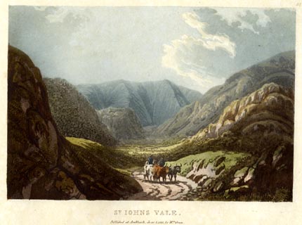 click to enlarge click to enlargeGN0530.jpg Plate 32 in Lake Scenery. printed at upper right:- "32" printed at bottom:- "ST. JOHNS VALE. / Published at Ambleside, June 1, 1815, by Wm. Green." item:- Armitt Library : A6646.30 Image © see bottom of page |
|
|
|
||
| evidence:- | old map:- Hall 1820 (Cmd) placename:- St Johns |
|
| source data:- | Map, hand coloured engraving, Cumberland, scale about 21 miles
to 1 inch, engraved by Sidney Hall, published by S Leigh, 18
Strand, London, 1820-31. click to enlarge click to enlargeHA14.jpg "St Johns" circle, italic lowercase text; settlement item:- JandMN : 91 Image © see bottom of page |
|
|
|
||
| evidence:- | old print:- Fielding and Walton 1821 (plate 1) placename:- St John's Vale |
|
| source data:- | Print, coloured aquatint, Saddleback and St John's Vale, Cumberland, drawn by Theodore
H A Fielding, published by R Ackermann, 101 Strand, London, 1821.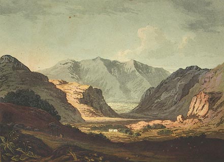 click to enlarge click to enlargeFW0101.jpg Frontispiece in A Picturesque Tour of the English Lakes. item:- Dove Cottage : 1993.R566.1 Image © see bottom of page |
|
|
|
||
| evidence:- | old drawing:- Aspland 1840s-60s placename:- St Johns Vale |
|
| source data:- | Drawing, pencil, St John's in the Vale, Cumberland, by Theophilus Lindsey Aspland,
1857.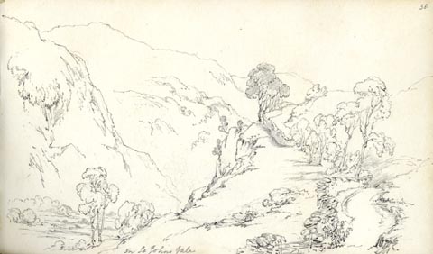 click to enlarge click to enlargeAS0548.jpg "In St Johns Vale" page number "38" item:- Armitt Library : 1958.389.48 Image © see bottom of page |
|
|
|
||
| evidence:- | old map:- Garnett 1850s-60s H placename:- Vale of St John |
|
| source data:- | Map of the English Lakes, in Cumberland, Westmorland and
Lancashire, scale about 3.5 miles to 1 inch, published by John
Garnett, Windermere, Westmorland, 1850s-60s.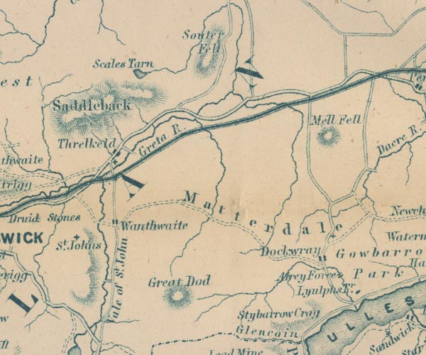 GAR2NY32.jpg "Vale of St. John" area item:- JandMN : 82.1 Image © see bottom of page |
|
|
|
||
| evidence:- | old text:- Martineau 1855 placename:- Vale of St John item:- book; Bridal of Triermain |
|
| source data:- | Guide book, A Complete Guide to the English Lakes, by Harriet
Martineau, published by John Garnett, Windermere, Westmorland,
and by Whittaker and Co, London, 1855; published 1855-76. goto source Page 70:- "[Vale of St. John] ..." "One would like to know how often the Bridal of Triermain has been read within that vale. The Castle Rock, in its disenchanted condition, is a prominent object in approaching the vale [Vale of St. John] ..." "... The narrow vale is full of character and charm, from end to end; and at its northern extremity it comes out upon a spot of strong historical interest. The village of Threlkeld" |
|
|
|
||
| evidence:- | old print:- Postlethwaite 1877 item:- |
|
| source data:- | Print, photograph of microscope section, St John's Microgranite, Cumberland, published
by W H Moss and Sons, 13 Lowther Street, Whitehaven, Cumberland, 1877 edn 1913.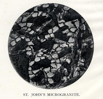 click to enlarge click to enlargePST312.jpg Tipped in opposite p.33 of Mines and Mining in the English Lake District, by John Postlethwaite. printed, bottom "ST JOHN'S MICROGRANITE" item:- JandMN : 162.14 Image © see bottom of page |
|
|
|
||
| evidence:- | old photograph:- Bell 1880s-1940s |
|
| source data:- | Photograph, sepia, St John's in the Vale, St John's Castlerigg and Wythburn, Cumberland,
by Herbert Bell, photographer, Ambleside, Westmorland, 1890s.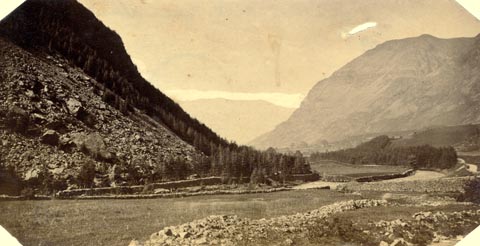 click to enlarge click to enlargeHB0746.jpg item:- Armitt Library : ALPS409 Image © see bottom of page |
|
|
|
||
| evidence:- | old photograph:- Bell 1880s-1940s |
|
| source data:- | Photograph, black and white, St John's in the Vale, St John's Castlerigg and Wythburn,
Cumberland, by Herbert Bell, photographer, Ambleside, Westmorland, 1890s.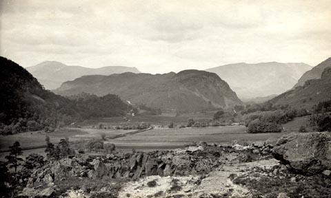 click to enlarge click to enlargeHB0730.jpg item:- Armitt Library : ALPS394 Image © see bottom of page |
|
|
|
||
| evidence:- | old print:- Bemrose 1881 placename:- Vale of St John |
|
| source data:- | Print, uncoloured, Vale of St John and Saddleback, Cumberland, published by Bemrose
and Sons, 23 Old Bailey, London and Derby, by A B Moss, Carlisle, Cumberland, and
by T Wilson, Kendal, Westmorland, about 1881.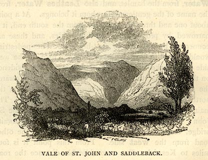 click to enlarge click to enlargeBEM118.jpg On p.64 of a Handy Guide to the English Lakes and Shap Spa. printed at bottom:- "VALE OF ST. JOHN AND SADDLEBACK." item:- JandMN : 455.20 Image © see bottom of page |
|
|
|
||
| evidence:- | old print:- Heaton Cooper 1905 (edn 1908) placename:- Vale of St John, The |
|
| source data:- | Print, colour halftone, The Vale of St John, near Keswick, St John's Castlerigg and
Wythburn, Cumberland, from a watercolour painting by Alfred Heaton Cooper, 1903, published
by Adam and Charles Black, London, 2nd edn 1908.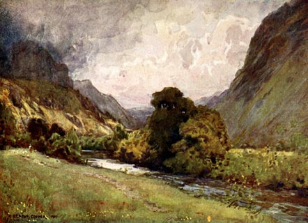 click to enlarge click to enlargeHC0153.jpg Opposite p.154 of The English Lakes, painted by Alfred Heaton Cooper, described by William T Palmer. printed at tissue opposite the print:- "THE VALE OF ST. JOHN, NEAR KESWICK" printed at signed lower left:- "A HEATON COOPER [1903]" item:- JandMN : 468.53 Image © see bottom of page |
|
|
|
||
| evidence:- | text:- Mason 1907 (edn 1930) placename:- Vale of St John's |
|
| source data:- | Text book, The Ambleside Geography Books bk.III, The Counties of
England, by Charlotte M Mason, published by Kegan Paul, Trench,
Trubner and Co, Broadway House, 68-74 Carter Lane, and the
Parents' Educational Union Office, 26 Victoria Street, London,
edn 1930. MSN1P021.txt Page 21:- "..." "At the head of Thirlmere the road turns, and we get a peep down the sweet Vale of St. John's, watered by the Greta river. ..." |
|
|
|
||
| evidence:- | old print:- placename:- St John's Vale |
|
| source data:- | Print, halftone photograph, St John's Vale, Keswick, by Mayson's, Keswick, published
by Cumberland Motor Services, Tangier Street, Whitehaven, Cumberland, about 1926.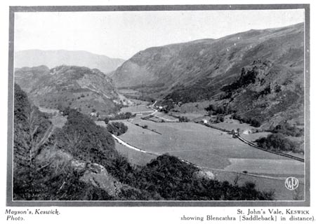 click to enlarge click to enlargeCS107.jpg On p.27 of Cumberland its Lakes and Mountains. lower right "WP" printed, bottom, left right "Mayson's, Keswick, Photo. / St John's Vale, KESWICK showing Blencathra (Saddleback) in distance)." item:- JandMN : 1022.7 Image © see bottom of page |
|
|
|
||
| evidence:- | old print:- Ritter 1849 placename:- St John's Vale item:- harvest; corn stooks |
|
| source data:- | Print, uncoloured engraving, St John's Vale, St John's Castlerigg and Wythburn, Cumberland,
published by the Religious Tract Society, The Depository, 56 Paternoster Row, and
65 St Paul's Churchyard, London, 1849?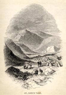 click to enlarge click to enlargeRT0105.jpg Tipped opposite p.178 of Loitering among the Lakes of Cumberland and Westmoreland, by Paul Ritter? printed at bottom:- "ST. JOHN'S VALE." item:- Fell and Rock Climbing Club : 2.6 Image © see bottom of page |
|
|
|
||
| evidence:- | old print:- Prior 1865 placename:- Vale of St John |
|
| source data:- | Print, uncoloured engraving, The Vale of St John and Saddleback, Cumberland, published
by John Garnett, Windermere, Westmorland, and by Simpkin, Marshall and Co, London,
1865.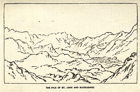 click to enlarge click to enlargePI0111.jpg Included on page 87 of the guide book, Ascents and Passes in the Lake District of England, by Herman Prior. printed at bottom:- "VALE OF ST. JOHN AND SADDLEBACK." item:- JandMN : 235.13 Image © see bottom of page |
|
|
|
||
| evidence:- | old print:- Sylvan 1847 placename:- Vale of St John |
|
| source data:- | Print, engraving, Vale of St John, and Saddleback, Cumberland, published by John Johnstone,
Paternoster Row, London, et al, 1847.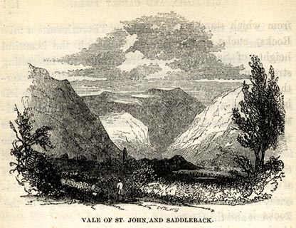 click to enlarge click to enlargeSYL144.jpg On p.182 of Sylvan's Pictorial Guide to the English Lakes. printed at bottom:- "VALE OF ST. JOHN, AND SADDLEBACK." item:- Armitt Library : A1201.44 Image © see bottom of page |
|
|
|
||
| evidence:- | old print:- Harwood 1842 placename:- Vale of St John |
|
| source data:- | Print, uncoloured engraving, Saddleback from the Vale of St John, Cumberland, engraved
and published by John and Frederick Harwood, 26 Fenchurch Street, London, 1842.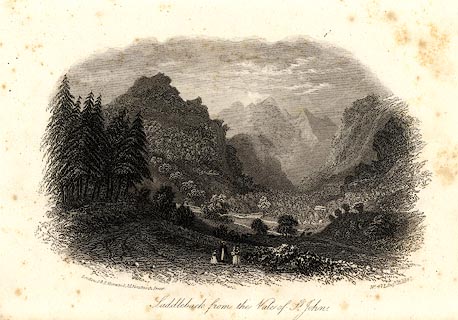 click to enlarge click to enlargeHRW211.jpg printed at bottom left, right, centre:- "London, J &F. Harwood, 26, Fenchurch Street. / No.471 Augt. 18, 1842. / Saddleback from the Vale of St. John." item:- JandMN : 166.11 Image © see bottom of page |
|
|
|
||
| evidence:- | outline view:- Tattersall 1836 (version 1869) placename:- Vale of St John |
|
| source data:- | Print, hand coloured, Vale of St John, from the South, Cumberland, drawn by George
Tattersall, 1836, engraved by W F Topham, published by T J Allman, 463 Oxford Street,
London, 1869.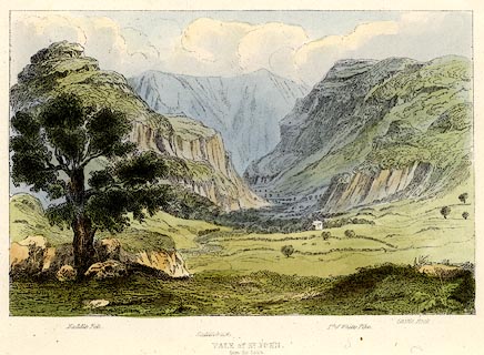 click to enlarge click to enlargeTAT208.jpg Included in The Lakes of England, by W F Topham. printed at bottom:- "VALE OF ST. JOHN, / from the South." printed at bottom:- "Naddle Fell. / Saddleback. / Pt. of White Pike. / Castle Rock." item:- Armitt Library : A1067.8 Image © see bottom of page |
|
|
|
||
| evidence:- | outline view:- Tattersall 1836 placename:- Vale of St John |
|
| source data:- | Print, engraving, View from Skiddaw, looking South, Cumberland, Westmorland and Lancashire,
drawn by George Tattersall, engraved by W F Topham, published by Sherwood and Co,
Paternoster Row, London, about 1836.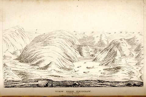 click to enlarge click to enlargeTAT137.jpg The print is captioned with mountain names and acts as an outline view. Tipped in opposite p.91 of The Lakes of England, by George Tattersall. printed at bottom:- "VIEW FROM SKIDDAW, / looking South. / [London Pubd. ...]" printed at p.91:- "... FOUR VIEWS FROM THE SUMMIT OF SKIDDAW. III. LOOKING SOUTH. / ... / 2. Vale of St. John, Cumberland. / 3. Castle Rock, Vale of St. John / ..." item:- Armitt Library : A1204.38 Image © see bottom of page |
|
|
|
||
| evidence:- | old print:- Green 1790s-1820s placename:- St John's Vale |
|
| source data:- | Print, uncoloured aquatint, St John's Vale from Leathes Park, drawn, engraved and
published by William Green, Ambleside, Westmorland, 1804.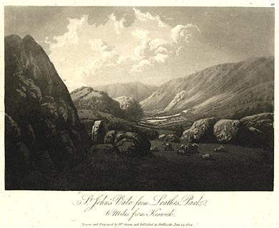 click to enlarge click to enlargePR0524.jpg Plate 11 from some series. printed at bottom:- "St. John's Vale from Leathes Park, / 6 Miles from Keswick. / Drawn and Engraved by Wm. Green, and Published at Ambleside, June 24, 1804." item:- Dove Cottage : 2008.107.473 Image © see bottom of page |
|
|
|
||
| hearsay:- |
Waller, then teacher and poet, John Richardson was born here. His best known dialect
poem is 'It's nobbut me'. |
|
|
|
||
| personal | ||
| person:- | waller; teacher; poet : Richardson, John |
|
| place:- | birthplace | |
| date:- | 1817 |
|
|
|
||
Lakes Guides menu.