 Old Cumbria Gazetteer
 |
 |
|
| Hammer Scar, Lakes | ||
| Hammer Scar | ||
| locality:- | Grasmere | |
| civil parish:- | Lakes (formerly Westmorland) | |
| county:- | Cumbria | |
| locality type:- | rocks | |
| locality type:- | hill | |
| coordinates:- | NY33760531 (etc) | |
| 1Km square:- | NY3305 | |
| 10Km square:- | NY30 | |
|
|
||
| evidence:- | old map:- OS County Series (Wmd 26 5) placename:- Hammer Scar |
|
| source data:- | Maps, County Series maps of Great Britain, scales 6 and 25
inches to 1 mile, published by the Ordnance Survey, Southampton,
Hampshire, from about 1863 to 1948. |
|
|
|
||
| evidence:- | outline view:- Otley 1823 (8th edn 1849) placename:- Hammerscar |
|
| source data:- | Engraving, outline view of mountains, Windermere looking towards the West from the
Road between Troutbeck and Bowness, drawn by T Binns, engraved by O Jewitt, opposite
p.4 of A Descriptive Guide of the English Lakes, by Jonathan Otley, 8th edition, 1849.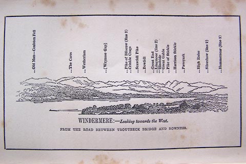 click to enlarge click to enlargeO80E03.jpg item:- Armitt Library : A1180.4 Image © see bottom of page |
|
|
|
||
| evidence:- | outline view:- Otley 1823 (8th edn 1849) placename:- Hammerscar |
|
| source data:- | Engraving, outline view of mountains, Grasmere from Red Bank Head, drawn by T Binns,
engraved by O Jewitt, opposite p.4 of A Descriptive Guide of the English Lakes, by
Jonathan Otley, 8th edition, 1849.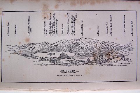 click to enlarge click to enlargeO80E04.jpg item:- Armitt Library : A1180.5 Image © see bottom of page |
|
|
|
||
| evidence:- | outline view:- Otley 1823 (5th edn 1834) |
|
| source data:- | Print, woodcut outline view, The Mountains of Grasmere and
Rydal, by Jonathan Otley, Keswick, Cumberland, 1830.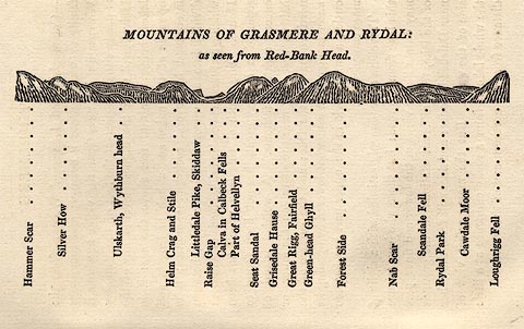 click to enlarge click to enlargeOT2E03.jpg Printed on p.15 of A Concise Description of the English Lakes, by Jonathan Otley, 5th edition, 1834. "MOUNTAINS OF GRASMERE AND RYDAL: as seen from Red-Bank Head." "Hammer Scar / Silver How / Ullskarth, Wythburn head / Helm Crag and Stile / Littledale Pike, Skiddaw / Raise Gap / Calva in Caldbeck Fells / Part of Helvellyn / Seat Sandal / Grisedale Hause / Great Rigg, Fairfield / Green-head Ghyll / Forest Side / Nab Scar / Scandale Fell / Rydal Park / Cawdale Moor / Loughrigg Fell" item:- JandMN : 48.4 Image © see bottom of page |
|
|
|
||
| evidence:- | outline view:- Tattersall 1836 (version 1869) placename:- Hammar Scarr |
|
| source data:- | Print, hand coloured, Grasmere, from Loughrigg Fell, Westmorland, drawn by George
Tattersall, 1836, engraved by W F Topham, published by T J Allman, 463 Oxford Street,
London, 1869.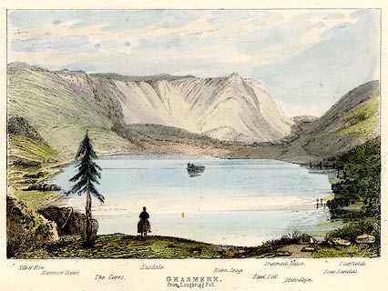 click to enlarge click to enlargeTAT205.jpg Included in The Lakes of England, by W F Topham. printed at bottom:- "GRASMERE, / from Loughrigg Fell." printed at bottom:- "Silver How. / Hammar Scarr. / The Carrs. / Easdale. / Helm Crag. / Steel Fell. / Dunmail Hause. / Helvellyn. / Seat Sandal. / Fairfield." item:- Armitt Library : A1067.5 Image © see bottom of page |
|
|
|
||
| evidence:- | outline view:- Tattersall 1836 placename:- Hammar Scarr |
|
| source data:- | Print, engraving, Rydal Water, from the South East, Westmorland, drawn by George Tattersall,
engraved by W F Topham, published by Sherwood and Co, Paternoster Row, London, about
1836.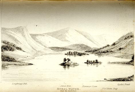 click to enlarge click to enlargeTAT111.jpg The print is captioned with mountain names and acts as an outline view. Tipped in opposite p.44 of The Lakes of England, by George Tattersall. printed at bottom:- "RYDAL WATER, / from the South East." printed at bottom left to right:- "Loughrigg Fell. / Silver How. / Hammar Scarr. / Pt. of Helm Crag. / Rydal Head." item:- Armitt Library : A1204.12 Image © see bottom of page |
|
|
|
||
 Lakes Guides menu.