 Old Cumbria Gazetteer
 |
 |
|
| milestone, Kirkandrews | ||
| site name:- | road, Longtown to Edinburgh | |
| civil parish:- | Kirkandrews (formerly Cumberland) | |
| county:- | Cumbria | |
| locality type:- | milestone | |
| coordinates:- | NY38687227 | |
| 1Km square:- | NY3872 | |
| 10Km square:- | NY37 | |
|
|
||
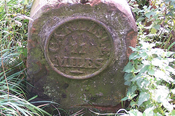 BMQ28.jpg Cast iron plate on stone:- "CARLISLE 11 MILES" (taken 15.9.2006) |
||
|
|
||
| evidence:- | old map:- OS County Series (Cmd 6) |
|
| source data:- | Maps, County Series maps of Great Britain, scales 6 and 25
inches to 1 mile, published by the Ordnance Survey, Southampton,
Hampshire, from about 1863 to 1948. "CARLISLE 11 M.S." |
|
|
|
||
| evidence:- | database:- Listed Buildings 2010 |
|
| source data:- | courtesy of English Heritage "MILESTONE AT NGR 386 722 / / A7 / KIRKANDREWS / CARLISLE / CUMBRIA / II / 78150 / NY3867772274" |
|
| source data:- | courtesy of English Heritage "Milestone. Early C19, for the Longtown to Edinburgh Turnpike. Red sandstone, cast iron plate. Squared stone with rounded top, has circular plate on front with raised letters CARLISLE 11 MILES. Whitewashed and letters picked out in black." |
|
|
|
||
 Lakes Guides menu.