 Old Cumbria Gazetteer
 |
 |
|
| milestone, Arthuret (3) | ||
| site name:- | road, Carlisle to Longtown | |
| locality:- | Longtown | |
| civil parish:- | Arthuret (formerly Cumberland) | |
| county:- | Cumbria | |
| locality type:- | milestone | |
| coordinates:- | NY38066838 | |
| 1Km square:- | NY3868 | |
| 10Km square:- | NY36 | |
| references:- | OS County Series |
|
|
|
||
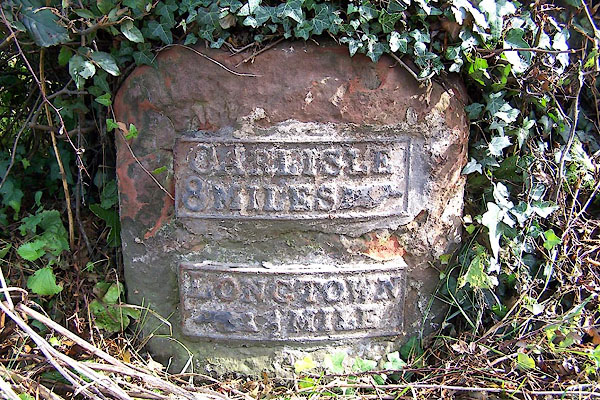 BMQ11.jpg Cast iron plates on stone:- "CARLISLE / 8 MILES [hand]" "LONGTOWN / [hand] ½MILE" (taken 15.9.2006) |
||
|
|
||
| evidence:- | old map:- OS County Series (Cmd 10) |
|
| source data:- | Maps, County Series maps of Great Britain, scales 6 and 25
inches to 1 mile, published by the Ordnance Survey, Southampton,
Hampshire, from about 1863 to 1948. "M.S. CARLISLE 8 LONGTOWN ½" |
|
|
|
||
| evidence:- | database:- Listed Buildings 2010 |
|
| source data:- | courtesy of English Heritage "MILESTONE AT NGR 3806 6838 / / CARLISLE ROAD / ARTHURET / CARLISLE / CUMBRIA / II / 78095 / NY3806668383" |
|
| source data:- | courtesy of English Heritage "Milestone. Probably early C19 for the Carlisle-Longtown Turnpike. Red sandstone, cast iron plates. Squared stone with rounded top has 2 plates to curved front, one with indication to CARLISLE 8 MILES and plate below LONGTOWN 1/2 MILE. Whitewashed and lettering picked out in black." |
|
|
|
||
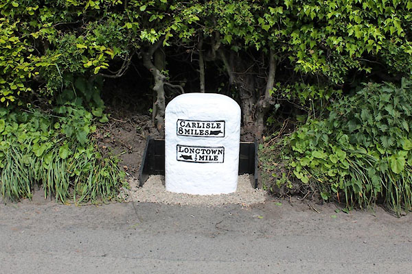 CEL70.jpg Cast iron plates on stone:- "CARLISLE / 8 MILES [hand]" "LONGTOWN / [hand] ½MILE" (taken 2015) courtesy of Terry Moore Image © Terry Moore |
||
|
|
||
 Lakes Guides menu.