 Old Cumbria Gazetteer
 |
 |
|
| Applethwaite, Windermere | ||
| Applethwaite | ||
| locality:- | Windermere | |
| civil parish:- | Windermere (formerly Westmorland) | |
| county:- | Cumbria | |
| locality type:- | locality | |
| 1Km square:- | SD4099 (etc) | |
| 10Km square:- | SD49 | |
|
|
||
| evidence:- | hearth tax returns:- Hearth Tax 1675 placename:- Applethwaite |
|
| source data:- | Records, hearth tax survey returns, Westmorland, 1674/75. "Applethwaite" |
|
|
|
||
| evidence:- | hearth tax returns:- Hearth Tax 1670 placename:- Aplethwaite |
|
| source data:- | Records, hearth tax returns, exchequer duplicates, Westmorland,
1670. "Aplethwaite" |
|
|
|
||
| evidence:- | old map:- Ogilby 1675 (plate 96) placename:- Winandermere |
|
| source data:- | Road strip map, hand coloured engraving, the Road from Kendal to
Cockermouth, and the Road from Egremond to Carlisle, scale about
1 inch to 1 mile, by John Ogilby, London, 1675.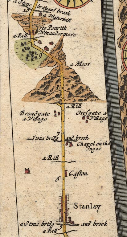 OG96m005.jpg In mile 9, Westmoreland. "Winandermere" houses each side of the road. item:- JandMN : 22 Image © see bottom of page |
|
|
|
||
| evidence:- | old map:- Bowen 1720 (plate 260) placename:- Winandermere |
|
| source data:- | Road strip map, uncoloured engraving, pl.260, The Road from
Kendal to Cockermouth, scale about 2 miles to 1 inch, with
sections in Westmorland and Cumberland, published by Emanuel
Bowen, St Katherines, London, 1720.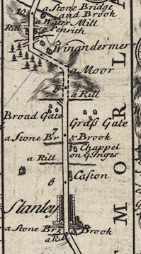 B260m05.jpg At mile 9. item:- private collection : 1.260 Image © see bottom of page |
|
|
|
||
| evidence:- | descriptive text:- Simpson 1746 item:- fishing; tithes |
|
| source data:- | Atlas, three volumes of maps and descriptive text published as
'The Agreeable Historian, or the Compleat English Traveller
...', by Samuel Simpson, 1746. goto source goto sourcePage 1021:- "... [Winander Mere] ... the Fishing belongs to Apelthwait a Hamlet in Winander-mere Parish, whose Rector has a Pleasure-boat upon it, and a certain Sum from every Fishing-boat in lieu of Tythes." |
|
|
|
||
| evidence:- | old map:- Jefferys 1770 (Wmd) placename:- Applethwaite |
|
| source data:- | Map, 4 sheets, The County of Westmoreland, scale 1 inch to 1
mile, surveyed 1768, and engraved and published by Thomas
Jefferys, London, 1770. J5SD49NW.jpg "Applethwaite" area item:- National Library of Scotland : EME.s.47 Image © National Library of Scotland |
|
|
|
||
| evidence:- | old text:- Camden 1789 placename:- Apelthwaite item:- fishing; tithe |
|
| source data:- | Book, Britannia, or A Chorographical Description of the Flourishing Kingdoms of England,
Scotland, and Ireland, by William Camden, 1586, translated from the 1607 Latin edition
by Richard Gough, published London, 1789. goto source Page 144:- "..." "... Winander mere ... all the fishing belongs to Apelthwaite in Winander mere parish in the said county, and all the tithe fish to the rector thereof, who has a pleasure boat on the lake and a prescription of so much a boat in lieu of the said tithe. ..." |
|
|
|
||
| evidence:- | old map:- Cooper 1808 placename:- Applethwaite |
|
| source data:- | Map, hand coloured engraving, Westmoreland ie Westmorland, scale
about 9 miles to 1 inch, by H Cooper, 1808, published by R
Phillips, Bridge Street, Blackfriars, London, 1808. click to enlarge click to enlargeCOP4.jpg "Applethwaite" circle; village or hamlet item:- Dove Cottage : 2007.38.53 Image © see bottom of page |
|
|
|
||
| evidence:- | old map:- Hall 1820 (Wmd) placename:- Applethwaite |
|
| source data:- | Map, hand coloured engraving, Westmoreland ie Westmorland, scale
about 14.5 miles to 1 inch, by Sidney Hall, London, 1820,
published by Samuel Leigh, 18 Strand, London, 1820-31. click to enlarge click to enlargeHA18.jpg "Applethwaite" circle, italic lowercase text; settlement item:- Armitt Library : 2008.14.58 Image © see bottom of page |
|
|
|
||
| evidence:- | old map:- Ford 1839 map placename:- Applethwaite |
|
| source data:- | Map, uncoloured engraving, Map of the Lake District of
Cumberland, Westmoreland and Lancashire, scale about 3.5 miles
to 1 inch, published by Charles Thurnam, Carlisle, and by R
Groombridge, 5 Paternoster Row, London, 3rd edn 1843. FD02SD49.jpg "Applethwaite" item:- JandMN : 100.1 Image © see bottom of page |
|
|
|
||
Lakes Guides menu.