 Old Cumbria Gazetteer
 |
 |
|
| Wrynose Pass, Ulpha | ||
| Wrynose Pass | ||
| civil parish:- | Ulpha (formerly Cumberland) | |
| civil parish:- | Dunnerdale-with-Seathwaite (formerly Lancashire) | |
| civil parish:- | Lakes (formerly Westmorland) | |
| county:- | Cumbria | |
| locality type:- | pass | |
| coordinates:- | NY27700270 | |
| 1Km square:- | NY2702 | |
| 10Km square:- | NY20 | |
| altitude:- | 1289 feet | |
| altitude:- | 393m | |
|
|
||
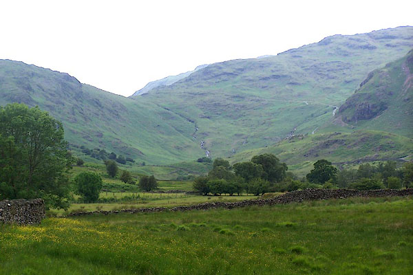 BMH02.jpg From near Slater Bridge. (taken 23.6.2006) 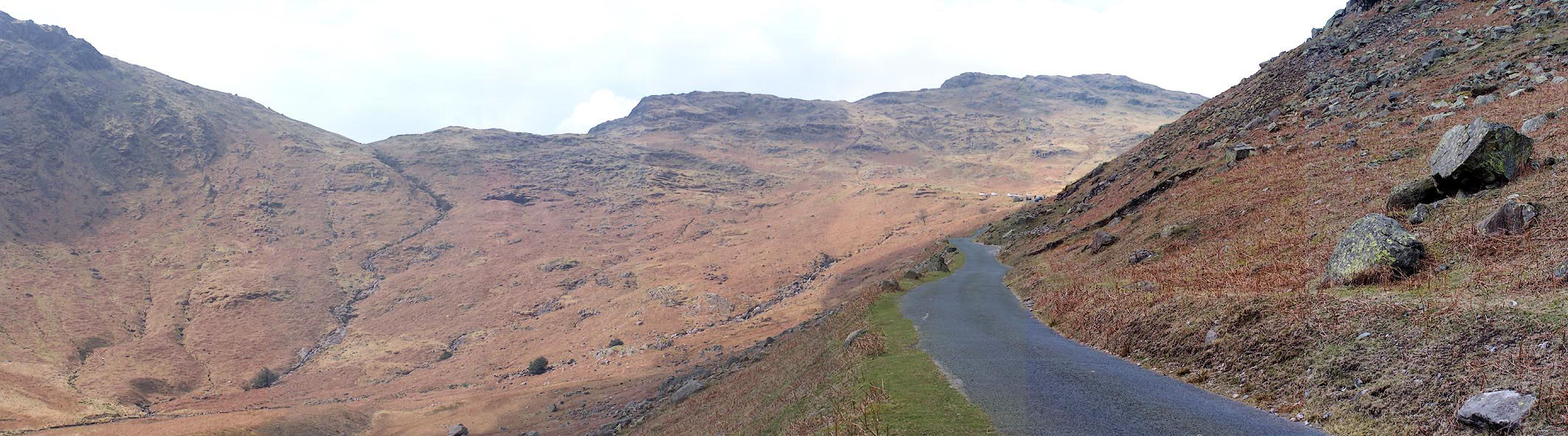 Click to enlarge BNL09.jpg East approach. (taken 26.3.2007) |
||
|
|
||
| evidence:- | old map:- Saxton 1579 placename:- Wrenose |
|
| source data:- | Map, hand coloured engraving, Westmorlandiae et Cumberlandiae Comitatus ie Westmorland
and Cumberland, scale about 5 miles to 1 inch, by Christopher Saxton, London, engraved
by Augustinus Ryther, 1576, published 1579-1645. Sax9NY20.jpg "wrenose" Large hillock. item:- private collection : 2 Image © see bottom of page |
|
|
|
||
| evidence:- | poem:- Drayton 1612/1622 text placename:- Wendrosse |
|
| source data:- | Poem, Poly Olbion, by Michael Drayton, published by published by
John Marriott, John Grismand and Thomas Dewe, and others?
London, part 1 1612, part 2 1622. goto source goto sourcepage 164:- "... Wendrosse ..." |
|
|
|
||
| evidence:- | old map:- Jansson 1646 placename:- Wrenose |
|
| source data:- | Map, hand coloured engraving, Cumbria and Westmoria, ie
Cumberland and Westmorland, scale about 3.5 miles to 1 inch, by
John Jansson, Amsterdam, Netherlands, 1646.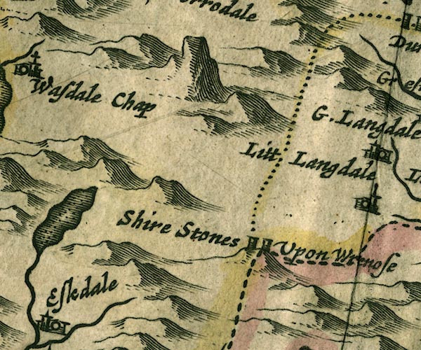 JAN3NY20.jpg "Wrenose" Implied by the label for the shire stones. item:- JandMN : 88 Image © see bottom of page |
|
|
|
||
| evidence:- | old map:- Badeslade 1742 placename:- Wrenose |
|
| source data:- | Map, uncoloured engraving, A Map of Cumberland North from
London, scale about 11 miles to 1 inch, with descriptive text,
by Thomas Badeslade, London, engraved and published by William
Henry Toms, Union Court, Holborn, London, 1742. click to enlarge click to enlargeBD10.jpg "... Wrenose" hillocks item:- JandMN : 115 Image © see bottom of page |
|
|
|
||
| evidence:- | descriptive text:- Simpson 1746 placename:- Wry Nose |
|
| source data:- | Atlas, three volumes of maps and descriptive text published as
'The Agreeable Historian, or the Compleat English Traveller
...', by Samuel Simpson, 1746. goto source "..." "Some of the Mountains in Cumberland are very remarkable for their Height, viz. the Mountain called Wry Nose, upon the Top of which, near the Highway-Side, are to be seen three Stones, commonly call'd Shire-Stones, ..." |
|
|
|
||
| evidence:- | old map:- Bowen and Kitchin 1760 placename:- Wry Nose Head |
|
| source data:- | Map, hand coloured engraving, A New Map of the Counties of
Cumberland and Westmoreland Divided into their Respective Wards,
scale about 4 miles to 1 inch, by Emanuel Bowen and Thomas
Kitchin et al, published by T Bowles, Robert Sayer, and John
Bowles, London, 1760.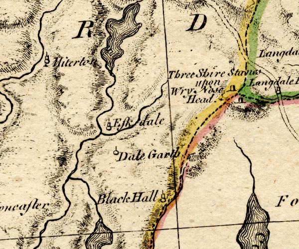 BO18SD19.jpg "Three Shire Stones upon Wry Nose Head" hill hachuring item:- Armitt Library : 2008.14.10 Image © see bottom of page |
|
|
|
||
| evidence:- | old map:- West 1784 map placename:- Wry Nose |
|
| source data:- | Map, hand coloured engraving, A Map of the Lakes in Cumberland,
Westmorland and Lancashire, scale about 3.5 miles to 1 inch,
engraved by Paas, 53 Holborn, London, about 1784.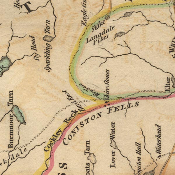 Ws02NY20.jpg item:- Armitt Library : A1221.1 Image © see bottom of page |
|
|
|
||
| evidence:- | old map:- Otley 1818 placename:- Wrynose |
|
| source data:- | Map, uncoloured engraving, The District of the Lakes,
Cumberland, Westmorland, and Lancashire, scale about 4 miles to
1 inch, by Jonathan Otley, 1818, engraved by J and G Menzies,
Edinburgh, Scotland, published by Jonathan Otley, Keswick,
Cumberland, et al, 1833.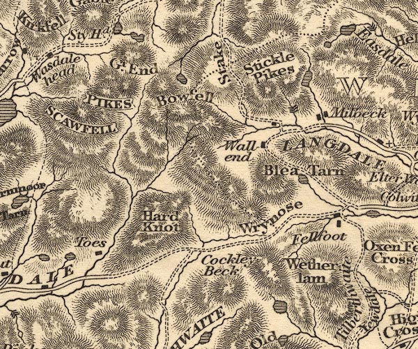 OT02NY20.jpg item:- JandMN : 48.1 Image © see bottom of page |
|
|
|
||
| evidence:- | outline view:- Otley 1823 (4th edn 1830) placename:- Wrynose Gap |
|
| source data:- | Print, engraving, outline view, Mountains of Coniston, Langdale, &c. as they appear
from the road between Troutbeck Bridge and Bowness, published by Jonathan Otley, Keswick,
Cumberland et al, 1830.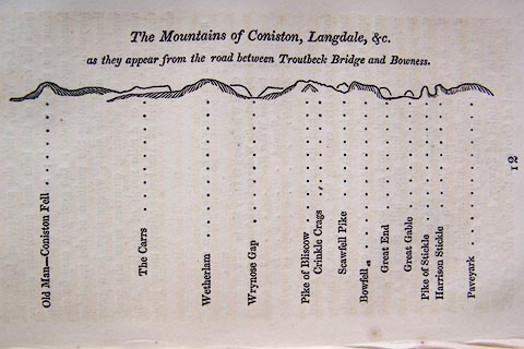 click to enlarge click to enlargeO75E04.jpg p.97 in A Concise Description of the English Lakes, by Jonathan Otley, 4th edition, 1830. "The Mountains of Coniston, Langdale, &c. / as they appear from the road between Troutbeck Bridge and Bowness." "Old Man - Coniston Fell / The Carrs / Wetherlam / Wrynose Gap / Pike of Bliscow / Crinkle Crags / Scawfell Pike / Bowfell / Great End / Great Gable / Pike of Stickle / Harrison Stickle / Paveyark" item:- Armitt Library : A1175.4 Image © see bottom of page |
|
|
|
||
| evidence:- | outline view:- Otley 1823 (5th edn 1834) placename:- Wrynose Gap |
|
| source data:- | Print, woodcut outline view, The Mountains of Coniston, Langdale, Etc, by Jonathan
Otley, Keswick, Cumberland, 1830.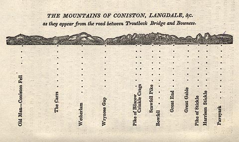 click to enlarge click to enlargeOT2E01.jpg Printed on p.7 of A Concise Description of the English Lakes, by Jonathan Otley, 5th edition, 1834. "THE MOUNTAINS OF CONISTON, LANGDALE, &c. as they appear from the road between Troutbeck Bridge and Bowness." Mountains in the view are listed:- "Old Man - Coniston Fell / The Carrs / Wetherlam / Wrynose Gap / Pike of Bliscow / Crinkle Crags / Scawfell Pike / Bowfell / Great End / Great Gable / Pike of Stickle / Harrison Stickle / Paveyark" item:- JandMN : 48.2 Image © see bottom of page |
|
|
|
||
| evidence:- | old drawing:- Aspland 1840s-60s |
|
| source data:- | Drawing, pencil, Wrynose Pass, Westmorland, by Theophilus Lindsey Aspland, 1852.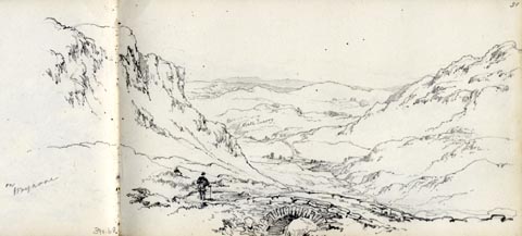 click to enlarge click to enlargeAS0368.jpg "on Wrynose" page number "51" item:- Armitt Library : 1958.390.68 Image © see bottom of page |
|
|
|
||
| evidence:- | old drawing:- Aspland 1840s-60s |
|
| source data:- | Drawing, pencil, Wrynose Pass, Westmorland, by Theophilus Lindsey Aspland, 1852.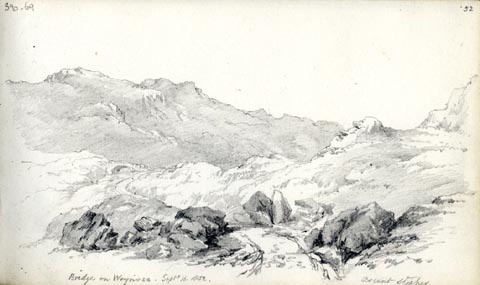 click to enlarge click to enlargeAS0369.jpg "Bridge on Wrynose. Septr 16. 1852. / ascent steeper" page number "52" item:- Armitt Library : 1958.390.69 Image © see bottom of page |
|
|
|
||
| evidence:- | outline view:- Martineau 1855 placename:- Wrynose Gap |
|
| source data:- | Print, engraving, outline view, Mountains on the West Side of Windermere, drawn by
L Aspland, engraved by W Banks, Edinburgh, published by John Garnett, Windermere,
Westmorland, and by Whittaker and Co, London, 1855.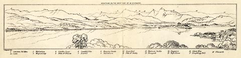 click to enlarge click to enlargeMNU102.jpg Folded in opposite p.7 in A Complete Guide to the English Lakes, by Harriet Martineau. "MOUNTAINS ON THE WEST SIDE OF WINDERMERE" "L Aspland Delt. / W Banks Sc Edinburgh." The view is captioned, numbers referring to mountains in the image:- "1 Coniston Old Man 1a Carrs 2 Wetherlam 3 Wrynose Gap 4 Crinkle Crags 5 Pike of Bliscow 6 Scawfell Pike 7 Bowfell 8 Hanging Knotts 9 Glaramara 10 Great End 11 Pike of Stickle 12 Harrison Stickle 13 Paveyark 14 Lingmoor 15 High Raise 16 Silver How 17 Loughrigg Fell 18 Ullscarth" item:- Armitt Library : A1159.2 Image © see bottom of page |
|
|
|
||
| evidence:- | old drawing:- Brockbank 1870s placename:- Wrynose Gap |
|
| source data:- | Drawing, pencil and ink wash, glacial moraine, drumlins, Little Langdale under Wrynose,
Langdales, Westmorland, by WH, 1870s, used by William Brockbank.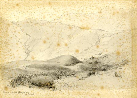 click to enlarge click to enlargePR1923.jpg "WH. / Moraine at the foot of Wrynose gap. / Little Langdale" "Wrynose Gap / W. Brockbank. F.G.S / 18" item:- Armitt Library : 1959.68.18 Image © see bottom of page |
|
|
|
||
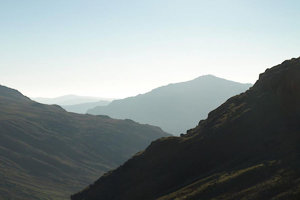 BTR07.jpg From Wrynose Pass, looking WSW towards Harter Fell, (taken 11.10.2010) 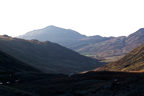 BLK35.jpg From Wrynose Pass, looking WSW towards Harter Fell. (taken 17.11.2005) |
||
|
|
||
Lakes Guides menu.