 Old Cumbria Gazetteer
 |
 |
|
| Windermere Ferry, Windermere lake | ||
| Windermere Ferry | ||
| site name:- | Windermere lake | |
| civil parish:- | Windermere (formerly Westmorland) | |
| civil parish:- | Claife (formerly Lancashire) | |
| county:- | Cumbria | |
| locality type:- | ferry | |
| coordinates:- | SD39109569 | |
| coordinates:- | SD39579581 | |
| 1Km square:- | SD3995 | |
| 10Km square:- | SD39 | |
|
|
||
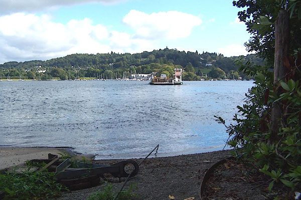
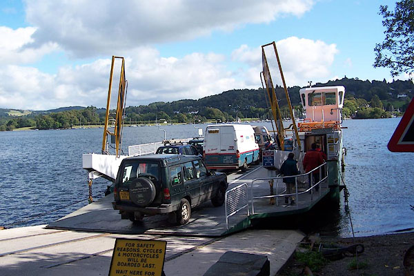 BJV14.jpg The ferry, west side, loading. (taken 16.9.2005) 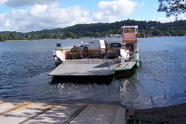 BJV15.jpg ... leaving ... (taken 16.9.2005) |
||
|
|
||
| evidence:- | old map:- OS County Series (Wmd 32 15) |
|
| source data:- | Maps, County Series maps of Great Britain, scales 6 and 25
inches to 1 mile, published by the Ordnance Survey, Southampton,
Hampshire, from about 1863 to 1948. "Ferry" |
|
| source data:- | Maps, County Series maps of Great Britain, scales 6 and 25
inches to 1 mile, published by the Ordnance Survey, Southampton,
Hampshire, from about 1863 to 1948. "Steam Ferry" |
|
|
|
||
| evidence:- | descriptive text:- Fiennes 1698 |
|
| source data:- | Travel book, manuscript record of Journeys through England
including parts of the Lake District, by Celia Fiennes, 1698. "... they [Furness Fells] have some parts of them that has wayes that they can by degrees in a compass ascend them and so they go onward in the countrys; they [local people] are ferried over the Lake when they go to market; ..." |
|
|
|
||
| evidence:- | old map:- Jefferys 1770 (Wmd) |
|
| source data:- | Map, 4 sheets, The County of Westmoreland, scale 1 inch to 1
mile, surveyed 1768, and engraved and published by Thomas
Jefferys, London, 1770. J5SD39NE.jpg "Ferry" no symbol, between two headlands item:- National Library of Scotland : EME.s.47 Image © National Library of Scotland |
|
|
|
||
| evidence:- | old map:- Crosthwaite 1783-94 (Win/Ble) placename:- Ferry, The |
|
| source data:- | Map, uncoloured engraving, An Accurate Map of the Grand Lake of
Windermere, scale about 2 inches to 1 mile, by Peter
Crosthwaite, Keswick, Cumberland, 1783, version published 1819. CT9SD39X.jpg "The Ferry" labelled across the lake item:- Armitt Library : 2008.14.102 Image © see bottom of page |
|
|
|
||
| evidence:- | old map:- West 1784 map |
|
| source data:- | Map, hand coloured engraving, A Map of the Lakes in Cumberland,
Westmorland and Lancashire, scale about 3.5 miles to 1 inch,
engraved by Paas, 53 Holborn, London, about 1784.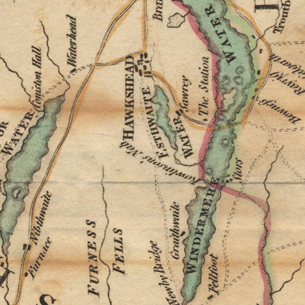 Ws02SD39.jpg The ferry across Windermere is not marked or labelled, but is implied by the layout of roads. item:- Armitt Library : A1221.1 Image © see bottom of page |
|
|
|
||
| evidence:- | old text:- Clarke 1787 item:- landscape mirror |
|
| source data:- | Guide book, A Survey of the Lakes of Cumberland, Westmorland,
and Lancashire, written and published by James Clarke, Penrith,
Cumberland, and in London etc, 1787; published 1787-93. goto source goto sourcePage 143:- "As I am aware of the curiosity which most persons have to know any small particulars of the life of an eminent man, I shall here insert a genuine anecdote of Mr Gray. This gentleman, who was no less remarkable for his timidity than his poetry, went (by land) to Bowness: Here he was told, that the best point of view was on the opposite shore, a little above Nab-Gate, (see plate X.) Curiosity and a love for natural beauty, were strong incitements on the one hand; but the reflection that there was no convenient way of attaining his desire, unless by crossing the Lake in a boat, was a reason almost equally strong for staying where he was. Being told, however, that not only horses and carriages frequently were ferried over there, but that the common carriers from Kendale to Hawkshead used that conveyance, he ventured to set forward blindfolded. He was accordingly landed near Nab-Gate, had viewed the landscape, and taken out his mirror in order to view it in miniature, when he saw the boat returning for more passengers; then asking his guide if any persons had ever been lost in crossing the ferry? the guide told him, that about the year 1634, forty-seven passengers were lost, owing to their own imprudence, by oversetting the boat as they were returning from Hawkshead fair." "This at once determined Mr Gray not to embark a second time, and he accordingly began to look about for some road to take him to Bowness by land; lifting up his eyes, he saw impending precipices on every side, (except the Lake,) a sight as alarming to him as a second voyage; he was so agitated at the prosect, that he trembled for fear, and had just command enough of himself to say to his guide, "Get me to Bowness any way;" nor did he utter another word, or ever look up, till he arrived there. ..." |
|
|
|
||
| evidence:- | old map:- Clarke 1787 map (Windermere S) |
|
| source data:- | Map, A Map of the Southern Part of the Lake Winandermere and its
Environs, scale about 6.5 ins to 1 mile, by James Clarke,
engraved by Samuel John Neele, 352 Strand, published by James
Clarke, Penrith, Cumberland and in London etc, 1787.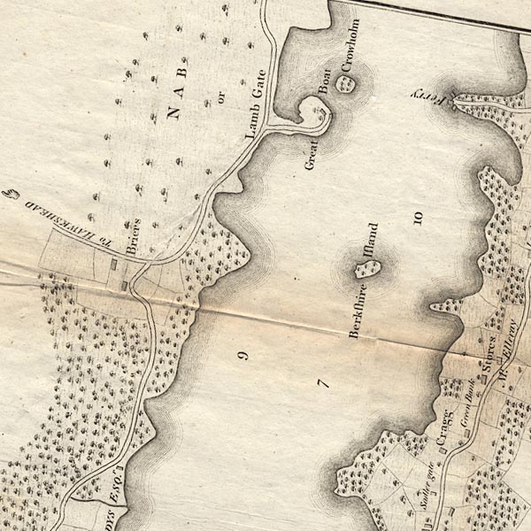 CLBSD39X.jpg "Ferry" Piers are shown at each end. item:- private collection : 10.11 Image © see bottom of page |
|
|
|
||
| evidence:- | old map:- Clarke 1787 map (Windermere N) |
|
| source data:- | Map, A Map of the Northern Part of the Lake Winandermere and its
Environs, scale about 6.5 ins to 1 mile, by James Clarke,
engraved by Samuel John Neele, 352 Strand, published by James
Clarke, Penrith, Cumberland and in London etc, 1787.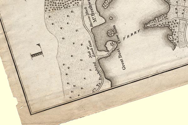 CLASD39X.jpg "FERRY" Labelled across the lake, with landing stages at each end. item:- private collection : 10.10 Image © see bottom of page |
|
|
|
||
| evidence:- | old text:- Camden 1789 (Gough Additions) item:- accident; drowning |
|
| source data:- | Book, Britannia, or A Chorographical Description of the Flourishing Kingdoms of England,
Scotland, and Ireland, by William Camden, 1586, translated from the 1607 Latin edition
by Richard Gough, published London, 1789. goto source Page 155:- "..." "About the year 1634, there were 47 persons drowned in this lake in passing the ferry, coming homewards from Hawkshead market on a storm arising." |
|
|
|
||
| evidence:- | old map:- Cary 1789 (edn 1805) |
|
| source data:- | Map, uncoloured engraving, Westmoreland, scale about 2.5 miles
to 1 inch, by John Cary, London, 1789; edition 1805.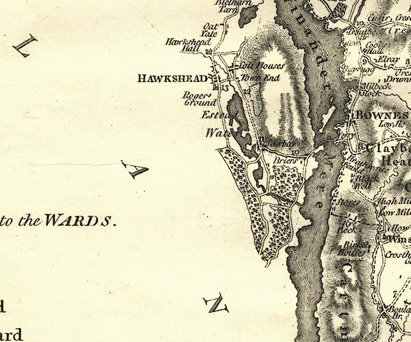 CY24SD39.jpg "Ferry" no symbol item:- JandMN : 129 Image © see bottom of page |
|
|
|
||
| evidence:- | road book:- Cary 1798 (2nd edn 1802) |
|
| source data:- | Road book, itineraries, Cary's New Itinerary, by John Cary, 181
Strand, London, 2nd edn 1802. goto source click to enlarge click to enlargeC38319.jpg page 319-320 "Ferry over Winander Mere" item:- JandMN : 228.1 Image © see bottom of page |
|
|
|
||
| evidence:- | old map:- Otley 1818 |
|
| source data:- | Map, uncoloured engraving, The District of the Lakes,
Cumberland, Westmorland, and Lancashire, scale about 4 miles to
1 inch, by Jonathan Otley, 1818, engraved by J and G Menzies,
Edinburgh, Scotland, published by Jonathan Otley, Keswick,
Cumberland, et al, 1833.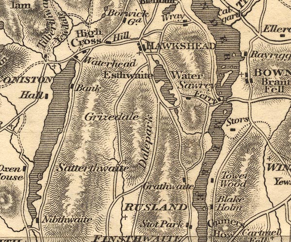 OT02SD39.jpg item:- JandMN : 48.1 Image © see bottom of page |
|
|
|
||
| evidence:- | old print:- Fielding and Walton 1821 (plate 9) |
|
| source data:- | Print, coloured aquatint, Ferry on Windermere, Westmorland, drawn by John Walton,
published by R Ackermann, 101 Strand, London, 1821.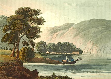 click to enlarge click to enlargeFW0109.jpg Tipped in opposite p.36 in A Picturesque Tour of the English Lakes. item:- Dove Cottage : 1993.R566.9 Image © see bottom of page |
|
|
|
||
| evidence:- | descriptive text:- Otley 1823 (5th edn 1834) |
|
| source data:- | Guide book, A Concise Description of the English Lakes, the
mountains in their vicinity, and the roads by which they may be
visited, with remarks on the mineralogy and geology of the
district, by Jonathan Otley, published by the author, Keswick,
Cumberland now Cumbria, by J Richardson, London, and by Arthur
Foster, Kirkby Lonsdale, Cumbria, 1823; published 1823-49,
latterly as the Descriptive Guide to the English Lakes. goto source Page 3:- "... A strait, near the middle of the lake [Windermere], has a public ferry-boat, on the way between Kendal and Hawkshead." goto sourcePage 97:- "From Coniston, those who feel no hesitation in crossing the Ferry on Windermere, may proceed through Hawkshead, by the side of Esthwaite Water, to the Ferry; and after taking a view of Windermere, from Mr. Curwen's Station-house, cross the water to Bowness, distant from Coniston Water-head 9 miles. Those who object to crossing the water, may either proceed from Coniston to Ambleside direct, 8 miles; or from the Ferry, by the western banks of the lake to Ambleside, distant from Coniston by this route 14 miles." |
|
|
|
||
| evidence:- | old map:- Garnett 1850s-60s H |
|
| source data:- | Map of the English Lakes, in Cumberland, Westmorland and
Lancashire, scale about 3.5 miles to 1 inch, published by John
Garnett, Windermere, Westmorland, 1850s-60s.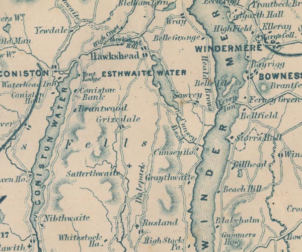 GAR2SD39.jpg "Ferry" dotted line across lake item:- JandMN : 82.1 Image © see bottom of page |
|
|
|
||
| evidence:- | old text:- Martineau 1855 |
|
| source data:- | Guide book, A Complete Guide to the English Lakes, by Harriet
Martineau, published by John Garnett, Windermere, Westmorland,
and by Whittaker and Co, London, 1855; published 1855-76. goto source Page 32:- "..." "... the heavy, roomy ferry-boat is ready: the horse is taken out of the car; and both are shipped. Two or three, or half-a-dozen people take advantage of the passage: the rowers, with their ponderous oars, are on the bench; and the great machine is presently afloat. The Ferry House looks more tempting than ever when seen from under its own sycamores,- jutting out as it does between quiet bays on either hand. The landing takes place on the opposite promontory: the horse is put to, and the traveller is presently at his inn. ..." |
|
|
|
||
| evidence:- | old photograph:- Payn 1867 item:- sailing boat; boat |
|
| source data:- | Photograph, sepia, Yachting at the Ferry, Windermere, Westmorland, by Garnett and
Sproat, published by J Garnett, Windermere, Westmorland, 1867.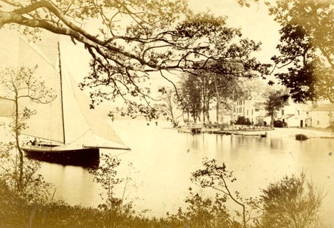 click to enlarge click to enlargePN0307.jpg Tipped in opposite p.13 of The Lakes in Sunshine, text by James Payn. printed at bottom:- "YACHTING AT THE FERRY, WINDERMERE." item:- Fell and Rock Climbing Club : 184.7 Image © see bottom of page |
|
|
|
||
| evidence:- | old map:- Prior 1874 map 1 placename:- Ferry |
|
| source data:- | Map, uncoloured engraving or lithograph? Winander Mere, scale
about 2.5 miles to 1 inch, published by John Garnett,
Windermere, Westmorland, 1874. click to enlarge click to enlargePI03M1.jpg "Ferry" dotted line across lake; ferry item:- private collection : 133.1 Image © see bottom of page |
|
|
|
||
| evidence:- | old photograph:- Bell 1880s-1940s |
|
| source data:- | Photograph, black and white, Windermere ferry approaching Ferry Nab, Windermere, Westmorland,
by Herbert Bell, photographer, Ambleside, Westmorland, 1890s.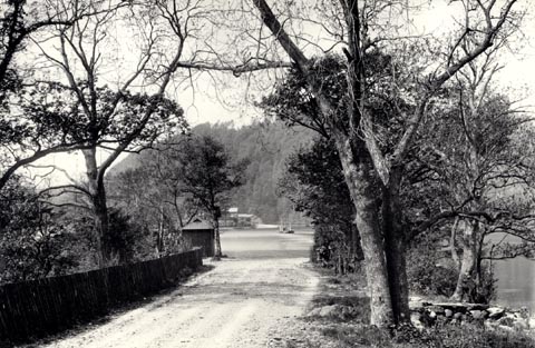 click to enlarge click to enlargeHB0852.jpg The ferry ticket booth on the left? item:- Armitt Library : ALPS523 Image © see bottom of page |
|
|
|
||
| evidence:- | old photograph:- Bell 1880s-1940s |
|
| source data:- | Photograph, black and white, Ferry Nab, Windermere, Westmorland, by Herbert Bell,
photographer, Ambleside, Westmorland, 1890s.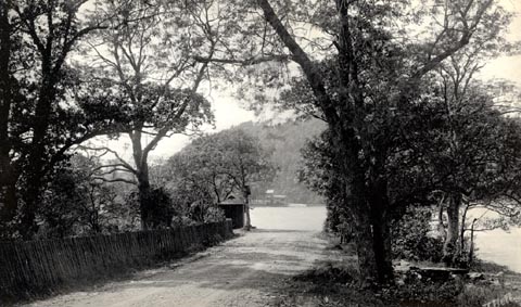 click to enlarge click to enlargeHB0817.jpg The ticket booth for the ferry on the left? internegative at lower right:- "H. Bell" stamped at reverse:- "HERBERT BELL / Photographer / AMBLESIDE" item:- Armitt Library : ALPS480 Image © see bottom of page |
|
|
|
||
| evidence:- | old photograph:- Bell 1880s-1940s |
|
| source data:- | Photograph, black and white, Windermere Ferry seen from Ferry Nab, Windermere, Westmorland,
by Herbert Bell, photographer, Ambleside, Westmorland, 1890s.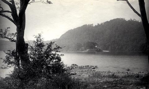 click to enlarge click to enlargeHB0816.jpg internegative at lower right:- "H. Bell" item:- Armitt Library : ALPS479 Image © see bottom of page |
|
|
|
||
| evidence:- | old photograph:- Bell 1880s-1940s item:- boat; ferry; carriage; horse |
|
| source data:- | Photograph, sepia, Windermere Ferry, Windermere lake, Westmorland, by Herbert Bell,
photographer, Ambleside, Westmorland, 1890s.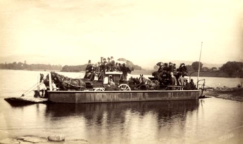 click to enlarge click to enlargeHB0815.jpg internegative at lower right:- "H. Bell" item:- Armitt Library : ALPS478 Image © see bottom of page |
|
|
|
||
| evidence:- | old photograph:- Bell 1880s-1940s |
|
| source data:- | Photograph, b/w, the ferry, Windermere lake, Westmorland and Lancashire, from Furness
Fell, by Herbert Bell, Ambleside, Westmorland, 1890s?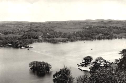 click to enlarge click to enlargeHB0273.jpg item:- Armitt Library : ALPS629 Image © see bottom of page |
|
|
|
||
| evidence:- | old photograph:- Bell 1880s-1940s item:- coach |
|
| source data:- | Photograph, Windermere Ferry, lake Windermere, by Herbert Bell, Ambleside, Westmorland,
1890s?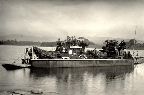 click to enlarge click to enlargeHB0248.jpg Of the two coaches, one is going to Coniston. item:- Armitt Library : ALPS579 Image © see bottom of page |
|
|
|
||
| evidence:- | old print:- Heaton Cooper 1905 (edn 1908) |
|
| source data:- | Print, colour halftone, The Old Ferry, Windermere, from Ferry Nab, Windermere, Westmorland,
from a watercolour painting by Alfred Heaton Cooper, published by Adam and Charles
Black, London, 2nd edn 1908.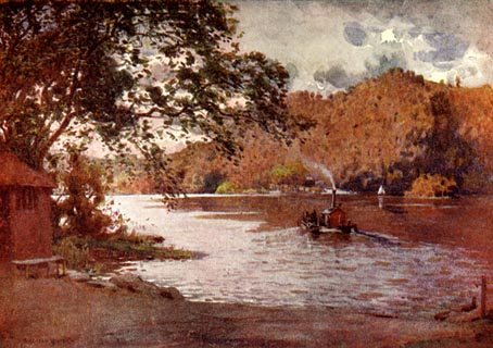 click to enlarge click to enlargeHC0106.jpg Opposite p.20 of The English Lakes, painted by Alfred Heaton Cooper, described by William T Palmer. printed at tissue opposite the print:- "THE OLD FERRY, WINDERMERE" printed at signed lower left:- "[A HEATON COOPER]" item:- JandMN : 468.6 Image © see bottom of page |
|
|
|
||
| evidence:- | old strip map:- CTC 1911 (Roads) |
|
| source data:- | Page 61 of Cyclists' Touring Club British Road Book new series vol.6, edited by F
B Sandford, published by Thomas Nelson and Sons, London etc, 1911.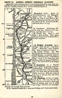 click to enlarge click to enlargeCTC258.jpg Strip road map, route 23, Coniston Ferry Leven Bridge Crooklands, scale roughly 5 miles to 1 inch. Together with an itinerary and gradient diagram. item:- JandMN : 491.61 Image © see bottom of page |
|
|
|
||
| evidence:- | old map:- Postlethwaite 1877 (3rd edn 1913) |
|
| source data:- | Map, uncoloured engraving, Map of the Lake District Mining Field, Westmorland, Cumberland,
Lancashire, scale about 5 miles to 1 inch, by John Postlethwaite, published by W H
Moss and Sons, 13 Lowther Street, Whitehaven, Cumberland, 1877 edn 1913.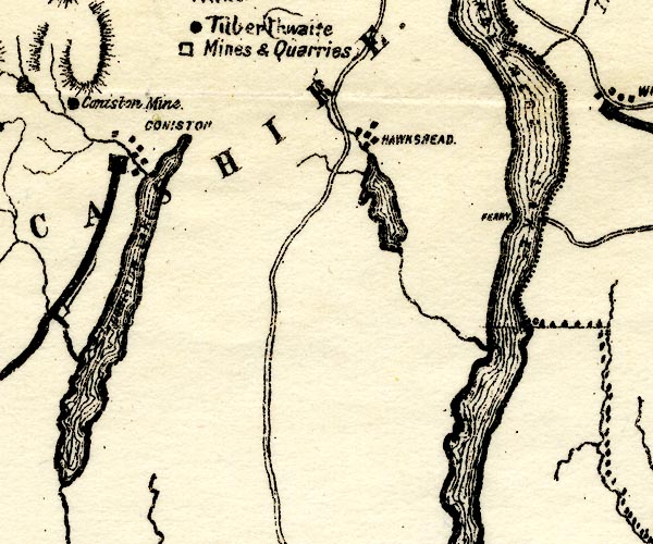 PST2SD39.jpg "FERRY" across Windermere item:- JandMN : 162.2 Image © see bottom of page |
|
|
|
||
| evidence:- | old print:- Robertson 1911 |
|
| source data:- | Print, lithograph? Windermere Ferry Inn, as it was in Wordsworth's Time, from a watercolour
by Arthur Tucker from an old print, published by Chatto and Windus, London, 1911.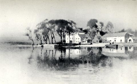 click to enlarge click to enlargeRSN119.jpg Tipped in opposite p.84 of Wordsworthshire by Eric Robertson. printed at bottom:- "WINDERMERE FERRY INN, AS IT WAS IN WORDSWORTH'S TIME / (From an old picture)" item:- JandMN : 197.19 Image © see bottom of page |
|
|
|
||
| evidence:- | old print:- Pearson 1900s |
|
| source data:- | Print, halftone photograph, Scene on Windermere, Westmorland, published by C Arthur
Pearson, Henrietta Street, London, 1900s.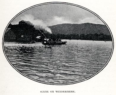 click to enlarge click to enlargePS1E30.jpg On p.77 of Pearson's Gossipy Guide to the English Lakes and Neighbouring Districts. printed at bottom:- "SCENE ON WINDERMERE." item:- Armitt Library : A1188.37 Image © see bottom of page |
|
|
|
||
| evidence:- | old print:- Pearson 1900s placename:- Ferry, The |
|
| source data:- | Print, halftone photograph, The Ferry, Windermere, Westmorland, published by C Arthur
Pearson, Henrietta Street, London, 1900s.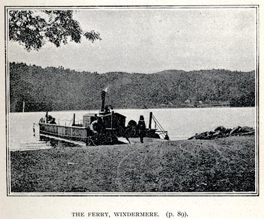 click to enlarge click to enlargePS1E29.jpg On p.73 of Pearson's Gossipy Guide to the English Lakes and Neighbouring Districts. printed at bottom:- "THE FERRY WINDERMERE. (p.89)." item:- Armitt Library : A1188.36 Image © see bottom of page |
|
|
|
||
| evidence:- | old print:- Matthew 1866 item:- boat; steam boat |
|
| source data:- | Print, engraving, Ferry Vale and Hotel, Windermere, Westmorland and Cumberland, drawn
by R Howe, engraved by J Saddler, published by J Richardson, Highgate, Kendal, Westmorland,
1866.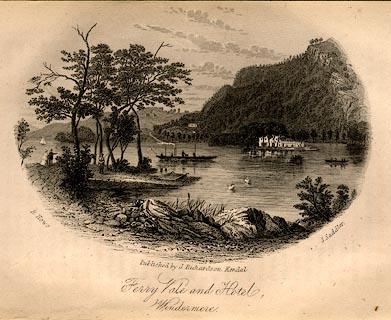 click to enlarge click to enlargeMW1E07.jpg Tipped in opposite p.19 of The English Lakes, Peaks and Passes, from Kendal to Keswick, by George King Matthew. printed at lower left, right, centre:- "R. Howe. / J. Saddler. / Published by J. Richardson, Kendal. / Ferry Vale and Hotel, Windermere." item:- Armitt Library : A1168.7 Image © see bottom of page |
|
|
|
||
| evidence:- | old print:- placename:- Bowness Ferry |
|
| source data:- | Print, uncoloured engraving, Windermere, from the Bowness Ferry, Westmorland, published
late 19th century?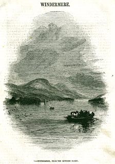 click to enlarge click to enlargePR0335.jpg On page 65 of The Land We Live In. The ferry carrying a cart and horses has just set out from the Bowness side. printed at bottom:- "1.- WINDERMERE, FROM THE BOWNESS FERRY." item:- Dove Cottage : 2008.107.335 Image © see bottom of page |
|
|
|
||
| evidence:- | old print:- Garnett 1850s-60s F |
|
| source data:- | Print, uncoloured engraving, The Ferry, Windermere, Westmorland, drawn and engraved
by William Banks and Son, Edinburgh, published by John Garnett, Windermere, Westmorland,
1850s-60s?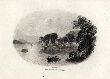 click to enlarge click to enlargeGAR712.jpg Found with Views of the English Lakes. printed at bottom:- "Drawn & Engd. by W. Banks &Son, Edinr. / THE FERRY, WINDERMERE." item:- JandMN : 165.12 Image © see bottom of page |
|
|
|
||
| evidence:- | old print:- Rose 1832-35 (vol.1 no.10) |
|
| source data:- | Print, uncoloured engraving, Windermere Lake, from the Ferry House, Claife, Cumberland
drawn by Thomas Allom, engraved by W Taylor, published by Fisher, Son and Co, London,
1832-35.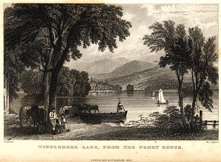 click to enlarge click to enlargePR0395.jpg vol.1 pl.10 in the set of prints, Westmorland, Cumberland, Durham and Northumberland Illustrated. Two horses are being led off the ferry. printed at bottom left, right, centre:- "T. Allom. / W. Taylor. / WINDERMERE LAKE, FROM THE FERRY HOUSE. / FISHER, SON &CO. LONDON, 1832." item:- Dove Cottage : 2008.107.4 Image © see bottom of page |
|
|
|
||
 BJV16.jpg ... left. Notice the wire cable, guide, etc. (taken 16.9.2005) 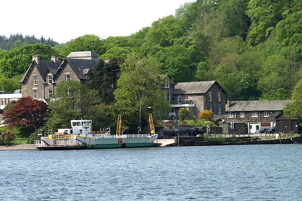 BPD51.jpg (taken 12.5.2008)  BZH33.jpg (taken 20.9.2013) |
||
|
|
||
| MN photo:- |
Crossing from E to W. |
|
 BZH27.jpg (taken 20.9.2013) 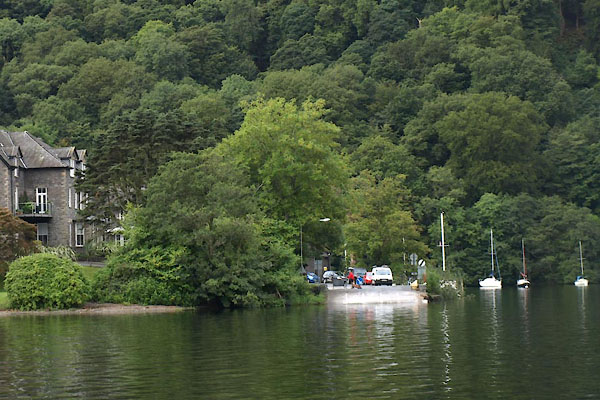 BZH28.jpg (taken 20.9.2013) |
||
|
|
||
|
|
||
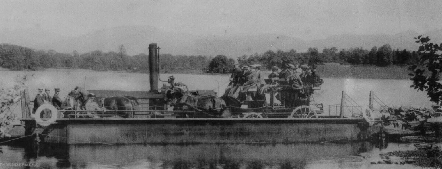 Click to enlarge BZH30.jpg 1905 (taken 20.9.2013) |
||
|
|
||
| hearsaystory:- |
On a stormy night a ghostly voice would call 'Boat' from the western shore. One boatman
answered this call, setting out from the Westmorland shore. Half an hour later he
returned; his boat full of water, himself white faced and speechless. He died without
telling his tale. The priest of St Mary's Holm laid the ghost with bell, book and
candle, in the rocks of the Cunsey shore. |
|
|
|
||
| hearsay:- |
19 October 1635 the ferry boat sank, carrying a wedding party from Hawkshead church,
and all were drowned. They are buried together at St Martin's, Bowness-on-Windermere.
A poem about the disaster was written by Richard Brathwaite of Burneside (the only
copy is in the Bodleian library, Oxford). |
|
|
|
||
| hearsay:- |
For about 500 years there was a rowing boat ferry here; from 1860 there was a steamer;
from 1970 diesel power. |
|
| There is/was an old wooden ferry boat sunk in the lake off Belle Isle; built 1799,
withdrawn 1860; 24 feet long, two 18 foot sweep oars, could carry one horse and cart;
at NY392964. |
||
|
|
||
Lakes Guides menu.