 Old Cumbria Gazetteer
 |
 |
|
| toll gate, Waterhead | ||
| gone | ||
| site name:- | road, Windermere to Ambleside | |
| locality:- | Waterhead | |
| civil parish:- | Lakes (formerly Westmorland) | |
| county:- | Cumbria | |
| locality type:- | toll gate (site) | |
| coordinates:- | NY37700312 (?) | |
| 1Km square:- | NY3703 | |
| 10Km square:- | NY30 | |
|
|
||
| evidence:- | old map:- OS County Series (Wmd 26 10) |
|
| source data:- | Maps, County Series maps of Great Britain, scales 6 and 25
inches to 1 mile, published by the Ordnance Survey, Southampton,
Hampshire, from about 1863 to 1948. "T.P." |
|
|
|
||
| evidence:- | old map:- Jefferys 1770 (Wmd) |
|
| source data:- | Map, 4 sheets, The County of Westmoreland, scale 1 inch to 1
mile, surveyed 1768, and engraved and published by Thomas
Jefferys, London, 1770.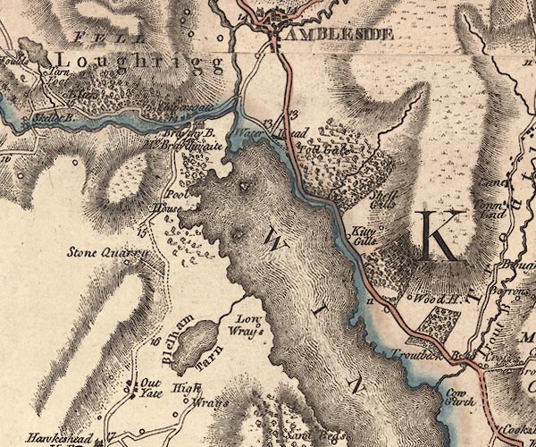 J5NY30SE.jpg "Toll Gate" toll house item:- National Library of Scotland : EME.s.47 Image © National Library of Scotland |
|
|
|
||
| evidence:- | old print:- Middiman 1784-92 placename:- Ambleside Turnpike |
|
| source data:- | Print, uncoloured engraving, View at Ambleside, Westmorland, drawn by C Powel, engraved
and published by Samuel Middiman, 3 Grafton Street, Tottenham Court Road, London,
1786.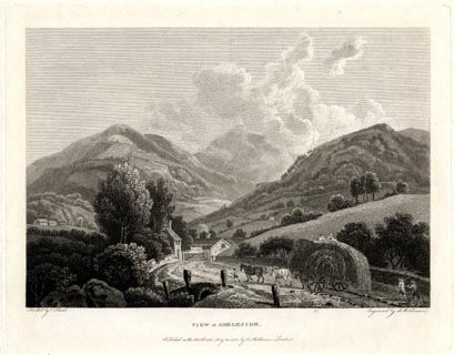 click to enlarge click to enlargeMM0602.jpg "Drawn by C. Powel. / Engrav'd by S. Middiman. / VIEW at AMBLESIDE. / Publish'd as the Act directs, May 25. 1786, by S. Middiman, London." Accompanying text:- "PLATE XXII." "VIEW at AMBLESIDE," "WESTMORELAND." "THE annexed View is taken on the Road from Winandermere, within a few Yards of Ambleside Turnpike, ..." item:- Armitt Library : A6863.2 Image © see bottom of page |
|
|
|
||
| evidence:- | old map:- Yates 1786 |
|
| source data:- | Map, engraving, The County Palatine of Lancaster, scale about 1
inch to 1 mile, by William Yates, published, London, 1786. "TB" |
|
|
|
||
| evidence:- | old map:- Clarke 1787 map (Windermere N) |
|
| source data:- | Map, A Map of the Northern Part of the Lake Winandermere and its
Environs, scale about 6.5 ins to 1 mile, by James Clarke,
engraved by Samuel John Neele, 352 Strand, published by James
Clarke, Penrith, Cumberland and in London etc, 1787.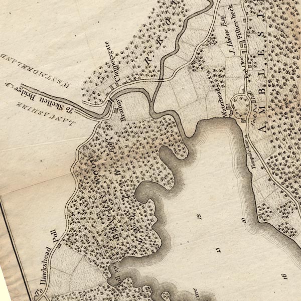 CLANY30R.jpg "Turnpike Gate" Marked by a line across the road, and a toll house beside. item:- private collection : 10.10 Image © see bottom of page |
|
|
|
||
| evidence:- | notice:- placename:- Water Head Toll Gate |
|
| source data:- | "AMBLESIDE Turnpike Road. / Tolls to Let. / ... the Tolls arising at the Toll Gates
upon the Ambleside Turnpike Road, called and known by the names of PLUMGARTHS, STAVELEY,
BONNINGATE CHAIN, WATER HEAD, and GRASMERE TOLL GATES, will be Let by Auction, ...
at the House of Mr.JOSEPH BARROW, the Commercial Inn, in Kendal ... which Tolls produced
the last year as follows, that is to say,- / Plumgarths and Staveley Gate, with Bonningate
Chain ... L331 / Waterhead Gate and Grasmere Gate ... L680 / Above the expenses of
collecting them , ... / WILLIAM PETTY, Clerk to the Trustees ... Kendal, August 24th,
1854. / T. ATKINSON, PRINTER, KENDAL." |
|
|
|
||
| evidence:- | old map:- Prior 1874 map 1 |
|
| source data:- | Map, uncoloured engraving or lithograph? Winander Mere, scale
about 2.5 miles to 1 inch, published by John Garnett,
Windermere, Westmorland, 1874. click to enlarge click to enlargePI03M1.jpg "Toll Gate" line across road; toll gate item:- private collection : 133.1 Image © see bottom of page |
|
|
|
||
 Act of Parliament Act of Parliament |
||
|
|
||
| evidence:- | perhaps old print:- Middiman 1784-92 |
|
| source data:- | Print, uncoloured engraving, View at Ambleside, Westmorland, painted by C Powel, engraved
and published by Samuel Middiman, London, 1786.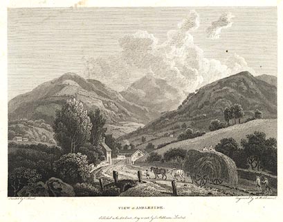 click to enlarge click to enlargeBNF32.jpg There is accompanying text in English and French:- "PLATE XXII. / VIEW at AMBLESIDE, WESTMORELAND. / THE annexed View is taken on the road from Winandermere, within a few Yards of Ambleside Turnpike, ..." item:- Dove Cottage : 2007.38.125 Image © see bottom of page |
|
|
|
||
 Lakes Guides menu.