Old Cumbria Gazetteer
 |
 |
|
||
| included in:- |
 road, Kendal to Skipton road, Kendal to Skipton |
|||
| road, Kirkby Lonsdale to Settle | ||||
| Kirkby Lonsdale to Settle | ||||
| Settle to Kirkby Lonsdale | ||||
| A65 | ||||
| civil parish:- | Kirkby Lonsdale (formerly Westmorland) | |||
| civil parish:- | Casterton (formerly Westmorland) | |||
| county:- | Cumbria | |||
| locality:- | Settle | |||
| county:- | North Yorkshire | |||
| locality type:- | road route | |||
| 10Km square:- | SD67 | |||
| 10Km square:- | SD77 | |||
| 10Km square:- | SD76 | |||
| 10Km square:- | SD86 | |||
|
|
||||
| evidence:- | old map:- OS County Series (Yrk 95) |
|||
| source data:- | Maps, County Series maps of Great Britain, scales 6 and 25
inches to 1 mile, published by the Ordnance Survey, Southampton,
Hampshire, from about 1863 to 1948. "KEIGHLEY AND KENDAL TRUST" along road |
|||
|
|
||||
| evidence:- | old map:- OS County Series (Lan 20) |
|||
| source data:- | Maps, County Series maps of Great Britain, scales 6 and 25
inches to 1 mile, published by the Ordnance Survey, Southampton,
Hampshire, from about 1863 to 1948. "KIRKBY LONSDALE AND MILNTHORPE TRUST" along road |
|||
|
|
||||
| evidence:- | old map:- Bowen and Kitchin 1760 |
|||
| source data:- | Map, hand coloured engraving, A New Map of the Counties of
Cumberland and Westmoreland Divided into their Respective Wards,
scale about 4 miles to 1 inch, by Emanuel Bowen and Thomas
Kitchin et al, published by T Bowles, Robert Sayer, and John
Bowles, London, 1760.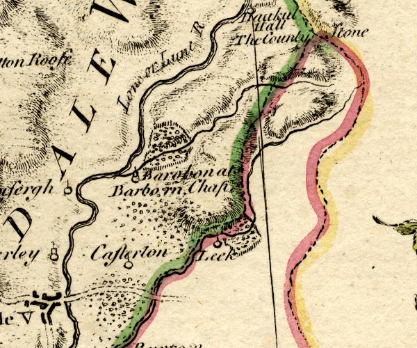 BO18SD68.jpg double line, dotted item:- Armitt Library : 2008.14.10 Image © see bottom of page |
|||
|
|
||||
| evidence:- | old map:- Jefferys 1770 (Wmd) |
|||
| source data:- | Map, 4 sheets, The County of Westmoreland, scale 1 inch to 1
mile, surveyed 1768, and engraved and published by Thomas
Jefferys, London, 1770.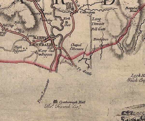 J5SD67NW.jpg "To Settle" double line; road, bold, main road, with mile numbers item:- National Library of Scotland : EME.s.47 Image © National Library of Scotland |
|||
|
|
||||
| evidence:- | descriptive text:- West 1778 (11th edn 1821) |
|||
| source data:- | Guide book, A Guide to the Lakes, by Thomas West, published by
William Pennington, Kendal, Cumbria once Westmorland, and in
London, 1778 to 1821. goto source Tour to the Caves in the West Riding of Yorkshire, late 18th century Page 244:- "..." "We mounted our horses at the bridge [Kirkby Lonsdale], about eleven o'clock, having ordered them down thither in order to save half an hour in going up the town for them. We travelled near the bottoms of the mountains, on the side of Lonsdale, along the turnpike-road, about an hour, being in three counties in that short interval, Westmorland, Lancashire, and Yorkshire, and amidst a variety of entertaining prospects. The number of small carts laden with coals, and each dragged by one sorry horse, that we met, was surprising to a stranger. Many of the smaller farmers, betwixt Kirkby-Lonsdale and Kendal, earn their bread with carrying coals, during most part of the year, from the pits at Ingleton, Black-Burton, or properly Burton-in-Lonsdale, to Kendal and the neighbouring places, for fuel, and burning lime, in order to manure their land. ..." "After we had got about six miles from Kirkby-Lonsdale, to a public-house called Thornton Church-stile, we stopped ..." goto sourcePage 253:- "..." "Early next morning we set off [from Ingleton] for Ingleton-fells, or Chapel-in-the-Dale, along the turnpike-road leading to Askrig and Richmond. ..." |
|||
|
|
||||
| evidence:- | old map:- Cary 1789 (edn 1805) |
|||
| source data:- | Map, uncoloured engraving, Westmoreland, scale about 2.5 miles
to 1 inch, by John Cary, London, 1789; edition 1805.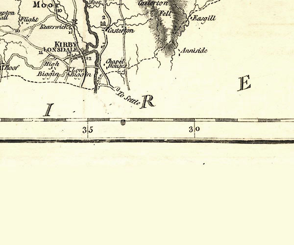 CY24SD67.jpg "To Settle" double line, bold light, numbered miles; main road item:- JandMN : 129 Image © see bottom of page |
|||
|
|
||||
| evidence:- | road map:- Cary 1790 (Wmd/edn 1792) |
|||
| source data:- | Road map, hand coloured engraving, Westmoreland, scale about
11.5 miles to 1 inch, by John Cary, 181 Strand, London, 1790,
edn 1792. click to enlarge click to enlargeCY16.jpg "to London by Settle" double line item:- JandMN : 44 Image © see bottom of page |
|||
|
|
||||
| evidence:- | road map:- Cary 1790 (Lan/edn 1792) |
|||
| source data:- | Road map, hand coloured engraving, Lancashire, scale about 18
miles to 1 inch, by John Cary, 181 Strand, London, 1790, edn
1792. click to enlarge click to enlargeCY46.jpg "to Settle" double line item:- JandMN : 418 Image © see bottom of page |
|||
|
|
||||
| evidence:- | road book:- Cary 1798 (2nd edn 1802) |
|||
| source data:- | Road book, itineraries, Cary's New Itinerary, by John Cary, 181
Strand, London, 2nd edn 1802. goto source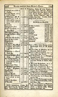 click to enlarge click to enlargeC38333.jpg page 333-334 "[LONDON to Kendal, through Halifax]" part of "KENDAL to Mansfield" part of reverse route item:- JandMN : 228.1 Image © see bottom of page |
|||
|
|
||||
| evidence:- | road book:- Cary 1798 (2nd edn 1802) |
|||
| source data:- | Road book, itineraries, Cary's New Itinerary, by John Cary, 181
Strand, London, 2nd edn 1802. goto source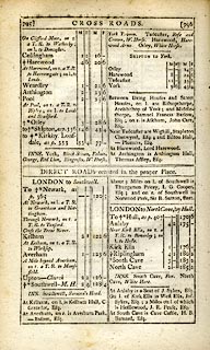 click to enlarge click to enlargeC38795.jpg page 795-796 "[YORK to Skipton and Kirkby Lonsdale.]" part of item:- JandMN : 228.2 Image © see bottom of page |
|||
|
|
||||
| evidence:- | old map:- Cooke 1802 |
|||
| source data:- | Map, Westmoreland ie Westmorland, scale about 12 miles to 1
inch, by George Cooke, 1802, published by Sherwood, Jones and
Co, Paternoster Road, London, 1824. click to enlarge click to enlargeGRA1Wd.jpg "to London by Settle / to Askrig" double line, light dark solid; road item:- Hampshire Museums : FA2000.62.4 Image © see bottom of page |
|||
|
|
||||
| evidence:- | old map:- Cooke 1802 |
|||
| source data:- | Map, West Riding of Yorkshire, ie West Yorkshire, scale about 21
miles to 1 inch, by George Cooke, 1802, bound in Gray's New Book
of Roads, 1824, published by Sherwood, Jones and Co, Paternoster
Road, London, 1824.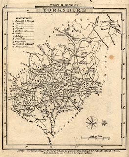 click to enlarge click to enlargeGRA1Wy.jpg "to Kirkby Lonsdale" double line, light dark solid; road item:- Hampshire Museums : FA2000.62.12 Image © see bottom of page |
|||
|
|
||||
| evidence:- | old map:- Laurie and Whittle 1806 |
|||
| source data:- | Road map, Completion of the Roads to the Lakes, scale about 10
miles to 1 inch, by Nathaniel Coltman? 1806, published by Robert
H Laurie, 53 Fleet Street, London, 1834. click to enlarge click to enlargeLw18.jpg bold line; 'Principal Travelling Roads' item:- private collection : 18.18 Image © see bottom of page |
|||
|
|
||||
| evidence:- | old map:- Wallis 1810 (Wmd) |
|||
| source data:- | Road map, Westmoreland, scale about 19 miles to 1 inch, by James
Wallis, 77 Berwick Street, Soho, 1810, published by W Lewis,
Finch Lane, London, 1835? click to enlarge click to enlargeWAL5.jpg "to Settle" double line, light bold; 'Turnpike Road' item:- JandMN : 63 Image © see bottom of page |
|||
|
|
||||
| evidence:- | gradient diagram:- Gall and Inglis 1890s-1900s (Roads) |
|||
| source data:- | Contour Road Book of England, Northern Division, by Harry R G Inglis, published by
Gall and Inglis, 25 Paternoster Square, London and Edinburgh, 1898.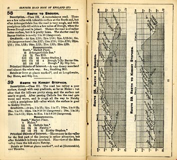 click to enlarge click to enlargeIG5058.jpg Itinerary, with gradient diagram, route 103, Skipton to Kendal, Yorkshire and Westmorland, 1898. item:- JandMN : 763.7 Image © see bottom of page |
|||
|
|
||||
 Act of Parliament Act of Parliament |
||||
|
|
||||
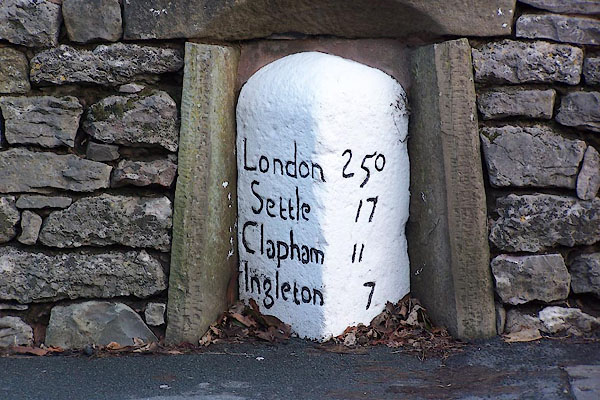
| places:- | Kirkby Lonsdale Ingleton, North Yorkshire Clapham, North Yorkshire Giggleswick, North Yorkshire Settle, North Yorkshire |
|||
|
|
||||
| places:- |
|
|||
|
||||
|
||||
Lakes Guides menu.