 Old Cumbria Gazetteer
 |
 |
|
| road, Ambleside to Penrith | ||
| Ambleside to Penrith | ||
| Penrith to Ambleside | ||
| locality:- | Ambleside | |
| civil parish:- | Lakes (formerly Westmorland) | |
| county:- | Cumbria | |
| locality type:- | route | |
| locality:- | Penrith | |
| civil parish:- | Penrith (formerly Cumberland) | |
| county:- | Cumbria | |
| locality type:- | route | |
|
|
||
| route parts:- |  Ambleside to Kirkstone Pass Kirkstone Pass to Patterdale Patterdale to Penrith Ambleside to Kirkstone Pass Kirkstone Pass to Patterdale Patterdale to Penrith |
|
|
|
||
| evidence:- | old map:- Laurie and Whittle 1806 |
|
| source data:- | Road map, Completion of the Roads to the Lakes, scale about 10
miles to 1 inch, by Nathaniel Coltman? 1806, published by Robert
H Laurie, 53 Fleet Street, London, 1834. click to enlarge click to enlargeLw18.jpg "[ ] to P 9 m. / P to P 14 Ms." dotted line; 'Cross Roads' item:- private collection : 18.18 Image © see bottom of page |
|
|
|
||
| evidence:- | old strip map:- Geographia 1925 |
|
| source data:- | Road book, with road strip maps and gradient diagrams, Premier Road Book of Great
Britain, by Alexander Gross and F Waite-Browne, published by Geographia, 55 Fleet
Street, London, about 1925?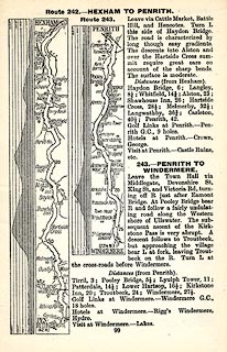 click to enlarge click to enlargeGE1099.jpg "Route 243. - PENRITH TO WINDERMERE." item:- Hampshire Museums : B1990.161.4 Image © see bottom of page |
|
|
|
||
 Lakes Guides menu.