Old Cumbria Gazetteer
 |
 |
|
||
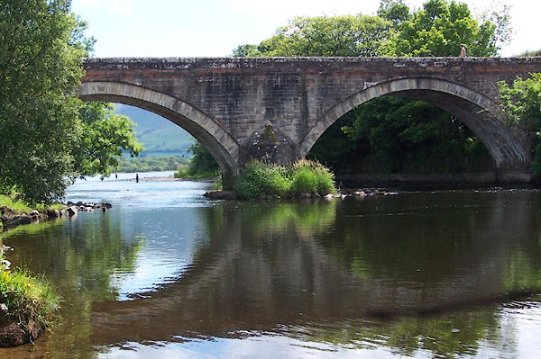
| Ouse Bridge, Blindcrake | ||||
| Ouse Bridge | ||||
| locality:- | Ouse Bridge | |||
| civil parish:- | Blindcrake (formerly Cumberland) | |||
| county:- | Cumbria | |||
| locality type:- | locality | |||
| locality type:- | buildings | |||
| coordinates:- | NY19983219 (etc) | |||
| 1Km square:- | NY1932 | |||
| 10Km square:- | NY13 | |||
|
|
||||
| evidence:- | descriptive text:- West 1778 (11th edn 1821) |
|||
| source data:- | Guide book, A Guide to the Lakes, by Thomas West, published by
William Pennington, Kendal, Cumbria once Westmorland, and in
London, 1778 to 1821. goto source goto sourceAddendum; Mr Gray's Journal, 1769 Page 208:- "..." "Oct. 6. Went in a chaise eight miles along the east side of Bassenthwaite-water to Ouse-bridge, ..." |
|||
|
|
||||
| evidence:- | old text:- Clarke 1787 placename:- Ouzebridge placename:- Ewsbridge |
|||
| source data:- | Guide book, A Survey of the Lakes of Cumberland, Westmorland,
and Lancashire, written and published by James Clarke, Penrith,
Cumberland, and in London etc, 1787; published 1787-93. goto source Page 93:- "..." "... Then arrive at Ouzebridge, commonly pronounced Ewsbridge, a very good and commodious inn, where we will dine." |
|||
|
|
||||
| evidence:- | old map:- Clarke 1787 map (Bassenthwaite Lake) placename:- Ousebridge |
|||
| source data:- | Map, A Map of Broadwater and its Environs, ie Bassenthwaite
Lake, scale about 6.5 ins to 1 mile, by James Clarke, engraved
by Neele, 352 Strand, published by James Clarke, Penrith,
Cumberland and in London etc, 1787.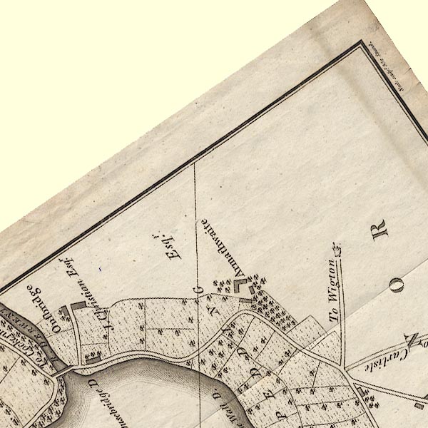 CL8NY23B.jpg "Ousebridge / J. Christian Esqr." item:- private collection : 10.8 Image © see bottom of page |
|||
|
|
||||
| evidence:- | road book:- Cary 1798 (2nd edn 1802) placename:- Ouse Bridge |
|||
| source data:- | Road book, itineraries, Cary's New Itinerary, by John Cary, 181
Strand, London, 2nd edn 1802. goto source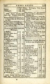 click to enlarge click to enlargeC38557.jpg page 557-558 "Ouse Bridge" item:- JandMN : 228.2 Image © see bottom of page |
|||
|
|
||||
| evidence:- | old map:- Wallis 1810 (Cmd) placename:- Ouse Bridge |
|||
| source data:- | Road map, hand coloured engraving, Cumberland, scale about 16
miles to 1 inch, by James Wallis, 77 Berwick Stree, Soho,
London, 1810. click to enlarge click to enlargeWL13.jpg "Ouse Bridge" village, hamlet, house, ... item:- Dove Cottage : 2009.81.10 Image © see bottom of page |
|||
|
|
||||
| hearsay:- |
Hearsay reports the sport of water horse racing in the late 18th century. Horses were
taken by barge to the middle of the lake, where the barge was ?sunk, the first horse
ashore is the winner. |
|||
|
|
||||
| places:- |
|
|||
|
||||
|
||||
|
||||
|
||||
|
||||
|
||||
|
||||
Lakes Guides menu.